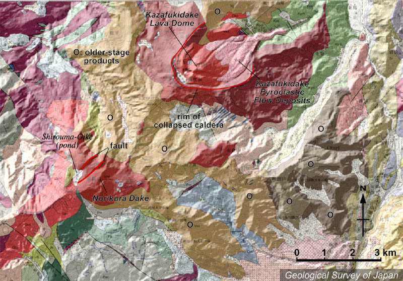
| 地質陰影図。中央左下に最高地点の乗鞍岳(茶色)。せき止め湖である白馬大池を横切る南西-北東方向に伸びた2本の断層で切られている。中央やや上に馬蹄形カルデラがあり、その中に中央火口丘の風吹岳溶岩ドーム(赤茶色)と火砕流堆積物(ピンク色)。淡茶色や暗茶色(右)は古期噴出物。 | |
|
|
| 地質図:中野 俊・竹内 誠・吉川敏之・長森英明・苅谷愛彦・奥村晃史・田口雄作(2002)白馬岳地域の地質。地域地質研究報告(5万分の1地質図幅)、産総研地質調査総合センター、105p。 | |||
| Topographic relief around Shirouma-oike Volcano combined with geological map. Norikuradake (the highest peak in this area) on the lower left. Two SW-NE trending faults cut across Norikuradake and Shirouma-oike Pond (dammed lake). Kazafukidake Lava Dome (central cone, indicated by reddish brown) and pyroclastic flow deposits (indicated by pink) are located in the horseshoe-shaped caldera in the center. Older-stage volcanic products are indicated by light and dark brown. | Map
courtesy of K. Nakajima |
||