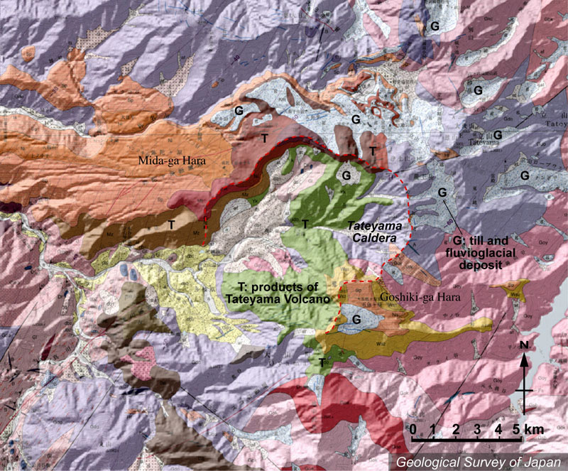
| 地質陰影図。ほぼ中央部に侵食カルデラである立山カルデラ。その北側から西方へ弥陀ヶ原などの平坦面が広がる。新期の溶岩類(赤茶色、濃茶色など)の部分(カルデラの北〜西)ではカルデラ壁が顕著にわかるが、カルデラの東〜南ではカルデラ壁の内外とも侵食が進み、五色ヶ原(カルデラの南東)をのぞいてはカルデラ地形がわかりにくい。カルデラの北東では、火山体の表面は氷河性の堆積物に覆われる。室堂や地獄谷はそこにある。室堂の東に雄山を中心とする立山三山があるが、そこは火山ではない。 | |
|
|
| 地質図:原山 智・高橋 浩・中野 俊・苅谷愛彦・駒澤正夫(2000)立山地域の地質。地域地質研究報告(5万分の1地質図幅)、地質調査所、218p。 | |||
| Topographic relief around Tateyama Volcano combined with geological map. Tateyama Caldera in the center, and flat plateau (such as Midagahara) in the northwestern side of Tateyama Caldera. The shape of caldera rim is clear in the northwestern side of caldera (composed of new lava flow indicated by brown of reddish brown), but it is entirely eroded in the southeastern side of caldera (except in Goshikigahara). Surface of the volcano is covered by till and fluvioglacial deposits in the east-northeastern side of the caldera. | Map courtesy of K. Nakajima |
||