Zao Volcano
1: Introduction - 2: Overview of geology for Zao Volcano and surrounding area
3: Topography of Zao Volcano
4: Eruptive history of Zao Volcano
5: Eruptions during historic times
6: Petrological characteristics of rocks of Zao Volcano - 7: Recent conditions - 8: Observation system for volcanic activities
9: Notes on volcanic hazard in the future
Acknowledgements / Reference
![]() PREV
PREV ![]() NEXT
NEXT
1: Introduction - 2: Overview of geology for Zao Volcano and surrounding area
1: Introduction
Zao Volcano is an active volcano, located at the central part of the volcanic front of the Northeast Japan Arc. This volcano has the highest number of eruption records in the Tohoku region. During 1894 to 1897, the most recent eruptive activities occurred from the Okama crater lake. Lake water overflowed at the same time as the eruptions, which caused lahars. During 1939 and 1943, volcanic gas was ejected from the base of Okama, which caused the color of the lake water to change, and the lake surface to be covered by sulfur. Furthermore, intermittent volcanic tremors have been observed since January 2013; thus, this volcano should be carefully monitored.
Numerous geological studies have been conducted on Zao Volcano. Relatively new studies (Oba and Konda, 1989; Sakayori, 1992) have divided its activities into three or four stages. In this study, based on these previous studies, we re-examined the stratigraphy of this volcano and divided the activities into six stages by focusing on the eruption style, the types of the volcanic edifices, and the characteristics of the magmas. We also re-constructed the volcanic history with previously reported ages (Takaoka et al., 1989) based on the new stratigraphy and new K-Ar dating for systematic sampling (Yamasaki et al., 2014). Furthermore, for the most recent stage of activity (Stage VI), we improved the accuracy of volcanic history based on detailed stratigraphic analysis with historical account research.
2: Overview of geology for Zao Volcano and surrounding area
2.1 Zao Volcano Group and Zao Volcano
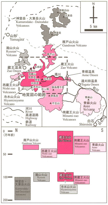
Zao Volcano has multiple peaks such as Kumanodake, Torikabutoyama, Gorodake, Jizosan, Goshikidake and Kattadake. The highest peak is Kumanodake of 1,840 m. Around Zao Volcano, a large number of stratovolcanoes lie in a north–south line, forming the Zao Volcano Group in a broad sense ( ![]() Figure 1). In this geological map, we define Zao Volcano to include volcanic edifices having eruption centers between Torikabutoyama to the north and Kattadake to the south through Jizosan and Kumanodake. These areas are equivalent to the area known as Chuo-zao (Central-zao) Volcanoes. Their eruption products distribute from the Zao dam and Zao Hot Springs areas in the north to the Sumikawa area in the south. Northward of Zao Volcano, there are Ryuzan Volcano (ca. 1 Ma; Takaoka et al., 1989), Gandosan Volcano (ca. 400–300 ka; Takaoka, 1988) and Kita-zao (North-zao) Volcanoes (ca. 2–1 Ma; Mimura, 2001) that include Kamurodake and Daitodake volcanoes. Also Minami-zao (South-zao) Volcanoes consisting of Ushiroeboshidake, Sugigamine, Byobudake, and Fubosan (ca. 1.3 Ma to 100 ka; Takaoka et al., 1989; Numakunai et al., 1992) and Hiyamizuyama Volcano (ca. 1.5 Ma; Yamasaki et al., 2014) are in southward and Nishi-zao (West-zao) Volcanoes in the westward. Furthermore, Aoso Volcano (ca. 400–300 ka; Ban et al., 1992;
Figure 1). In this geological map, we define Zao Volcano to include volcanic edifices having eruption centers between Torikabutoyama to the north and Kattadake to the south through Jizosan and Kumanodake. These areas are equivalent to the area known as Chuo-zao (Central-zao) Volcanoes. Their eruption products distribute from the Zao dam and Zao Hot Springs areas in the north to the Sumikawa area in the south. Northward of Zao Volcano, there are Ryuzan Volcano (ca. 1 Ma; Takaoka et al., 1989), Gandosan Volcano (ca. 400–300 ka; Takaoka, 1988) and Kita-zao (North-zao) Volcanoes (ca. 2–1 Ma; Mimura, 2001) that include Kamurodake and Daitodake volcanoes. Also Minami-zao (South-zao) Volcanoes consisting of Ushiroeboshidake, Sugigamine, Byobudake, and Fubosan (ca. 1.3 Ma to 100 ka; Takaoka et al., 1989; Numakunai et al., 1992) and Hiyamizuyama Volcano (ca. 1.5 Ma; Yamasaki et al., 2014) are in southward and Nishi-zao (West-zao) Volcanoes in the westward. Furthermore, Aoso Volcano (ca. 400–300 ka; Ban et al., 1992; ![]() Figure 1) lies to the east of the Minami-zao Volcanoes.
Figure 1) lies to the east of the Minami-zao Volcanoes.
2.2 Basement rocks of Zao Volcano
The basement rocks of Zao Volcano consist of granites and metamorphic rocks of the Cretaceous and Mesozoic ages and sedimentary rocks and pyroclastics of the Miocene and Cenozoic ages. Cretaceous granites are found at the central part of the map accompanied by metamorphic rocks (Yamada, 1972). Some granites are even found at the summit of Myogoho at 1,490 m. Miocene formations include the Takarazawa (Ichimura, 1957) and Narusawa Formations (Jinbo, 1965) to the north and west and the Gaga and Aone Formations (Yamada, 1972) to the south and east. All of these strata are composed mainly of tuff and tuff breccia and are found at elevations of approximately 1,000 m in the northwest and southwest.
![]() PREV
PREV ![]() NEXT
NEXT