Zao Volcano
1: Introduction - 2: Overview of geology for Zao Volcano and surrounding area
3: Topography of Zao Volcano
4: Eruptive history of Zao Volcano
5: Eruptions during historic times
6: Petrological characteristics of rocks of Zao Volcano - 7: Recent conditions - 8: Observation system for volcanic activities
9: Notes on volcanic hazard in the future
Acknowledgements / Reference
![]() PREV
PREV ![]() NEXT
NEXT
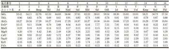
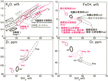
Fig.7 K2O‒SiO2 diagram of all stage rocks and FeO *, Cr, Zr‒SiO2 diagrams of rocks from stage V, Zao Volcano.
Data source: Sakayori (1992), Nishi et al, (2014), Takano et al, (2014). VE, volcanic edifice. FeO *, total iron calculated as FeO.
6: Petrological characteristics of rocks of Zao Volcano - 7: Recent conditions - 8: Observation system for volcanic activities
6: Petrological characteristics of rocks of Zao Volcano
Stage I rocks belong to the tholeiitic series, whereas Stage II–VI belong to the calc-alkaline series. The former is mainly basalt with subordinate amounts of andesite, and the latter is mainly andesite–dacite with basaltic andesite. Sakayori (1991) showed that compositional variation in the tholeiitic series was caused by crystallization differentiation of basaltic magma and that the calc-alkaline rocks were formed by mixing of basaltic and dacitic magma. In addition, the temperature of the dacite magma increased with time, and concentrations of incompatible elements in the basaltic magma are similar to that of back arc magma. Furthermore, Tatsumi et al. (2008) proposed that calc-alkaline basalt, originates from the upper mantle, whereas tholeiitic basalt originates from the lower crust. This theory of magma genesis is opposite the traditional findings obtained for Quaternary volcanoes in Tohoku area. Some eruption products of Stage VI have been studied in detail by Ban et al. (2008) in regard to crustal magmatic process. The analytical results of representative rocks for each volcanic edifice are shown in ![]() Table 2.
Table 2.
6.1 Temporal changes of general features of rocks
Rocks of Stages II to VI belong to medium-K series (Gill, 1981), but temporal change in whole rock compositions can bee seen. We sub-divided medium-K into low, intermediate and high-K levels ( ![]() Figure 7). Rocks of Stage II, III, IV and V belongs to low-K level, low- and intermediate-K levels, intermediate- and high-K levels and high-K level, respectively. During Stage VI, the slope of the trend is steeper than that of the other stages, depleted in low-K level in mafic part and in intermediate-K level in felsic part. Excluding the rocks of Stage VI, all contain mafic inclusions. The compositions of the inclusions are sometimes not fitted on the SiO2-poor extension of the host rock trends.
Figure 7). Rocks of Stage II, III, IV and V belongs to low-K level, low- and intermediate-K levels, intermediate- and high-K levels and high-K level, respectively. During Stage VI, the slope of the trend is steeper than that of the other stages, depleted in low-K level in mafic part and in intermediate-K level in felsic part. Excluding the rocks of Stage VI, all contain mafic inclusions. The compositions of the inclusions are sometimes not fitted on the SiO2-poor extension of the host rock trends.
6.2 Temporal change in petrologic features within stage
The compositions differ among units of the same stage. The changes within Stages II to V are significant. Rocks of these stages were formed through the mixing of magmas, thus, such changes in composition reflect temporal changes in both endmember magmas compositions, which reflects development of magma sources in the crust. As an example, ![]() Figure 7 shows temporal changes in of rock compositions of Stage V. Kumanodake–seiho Lavas and Pyroclastics, Kanshodaira Lavas, Jizosan Lava, Kumanodake Main Volcanic Edifice Lavas and Pyroclastics, and Umanose-kabu Lavas and Pyroclastics all plotted on the same trends, although the latter two have a high Cr content. The amount of SiO2 in former five units are more than 57.5%. The upper unit rocks have SiO2 contents less than 57%. Jizosan–higashi and Kumanodake–sancho lavas have poor FeO*% compared with that in the lower units. The Umanose Lava at the top has the lowest SiO2 content, and FeO* and Cr contents are notably higher than those in the other units.
Figure 7 shows temporal changes in of rock compositions of Stage V. Kumanodake–seiho Lavas and Pyroclastics, Kanshodaira Lavas, Jizosan Lava, Kumanodake Main Volcanic Edifice Lavas and Pyroclastics, and Umanose-kabu Lavas and Pyroclastics all plotted on the same trends, although the latter two have a high Cr content. The amount of SiO2 in former five units are more than 57.5%. The upper unit rocks have SiO2 contents less than 57%. Jizosan–higashi and Kumanodake–sancho lavas have poor FeO*% compared with that in the lower units. The Umanose Lava at the top has the lowest SiO2 content, and FeO* and Cr contents are notably higher than those in the other units.
7: Recent conditions
After the 1939–1943 activity, according to Japan Meteorological Agency (2013), the following volcanic unrests reported until 1995. In 1949, fumarolic gas activities increased in Marukoyama. During August 19–20, 1962, more than 20 rumblings, earthquake swarm and increase of fumarole were reported. In 1966, fumarolic activity was increased and some new hot springs were formed in Furikosawa. On October 4, 1971, rumbling was noted. On May 14, 28, and 29, 1972, more rumblings were reported. During July 8–September 1984, an earthquake swarm occurred in an area about 5 km southeast of Kumanodake. On July 14–15, 1990, an earthquake swarm occurred around Okama to Kattadake area. A large number of earthquakes occurred on February 22, 1992, in the western region of Fubosan, and on September 1 near the summit. In April 1995, a large number of earthquakes occurred near Fubosan and in December in the area 10 km northwest of Kumanodake.
Since then, no significant volcanic activity has been reported. However, on January 22, 2013, volcanic tremors were observed for the first time since the beginning of observation at Bodaira on September 1, 2010. These tremors have continued intermittently since that time (Japan Meteorological Agency, 2014). Low-frequency earthquakes were observed in April and October 2013. In addition, deep low-frequency earthquakes were observed on February 12, 2010, and on November 22, 2013. No other activity has been reported through May 2014.
8: Observation system for volcanic activities
During 2009–2010, the Japan Meteorological Agency installed seismometer, infrasound meter, tiltmeter, and global positioning system (GPS) devices in Bodaira. In addition, as an observation point for Tohoku University, seismometer, tiltmeter, and thermometer were installed at Zao Observatory, and seismometers were installed at Shichikashuku Observatory, which is outside of the geological map. In 2013, in response to observed volcanic tremors, Tohoku University installed new observatories and began observations in Sasaya and Fubosan, both outside of the geological map; in Kattadake at Kattadake shelter; and in Jizosan at Mount Zao dormitory of Yamagata University. In addition to the web camera system at the Togotta Hot Spring to the east of the volcano (outside of this geological map), the camera systems were newly installed at Kattadake south of Okama and Kanaya Kaminoyama to the west of the volcanic edifice (outside of this geological map).