Kuchinoerabujima Volcano
1: Introduction / 2: Outline of Geology
3: Eruption history
4: Petrology / 5: Historical eruptions / 6:Recent volcanic activities
7: Thermal activities and hot springs / 8: Observations of volcanic activities / 9: Mitigation of disasters
References
![]() PREV
PREV ![]() NEXT
NEXT
1: Introduction / 2: Outline of Geology
1: Introduction
Kuchinoerabujima Volcano is an active volcano forming Kuchinoerabu Island. Major eruptions during last two centuries occurred in 1841, 1931-33, and 1966. Though the surface activities stay quiet since the last eruption in 1980, seismic activities and ground deformation are continuing ( Iguchi, 2002; JMA, 2005 ).
Geological studies of Kuchinoerabujima Volcano have been carried out by Honma ( 1934, a and b ), Matsumoto ( 1935 ), and Tanakadate ( 1938 ) just after the activities of 1930s. Recently, Kobayashi and Naruo ( 1998 ) Kobayashi et al. ( 2002 ) Geshi and Kobayashi ( 2006 ) published the results of their studies.
This geological map is a compilation of past studies on Kuchinoerabujima Volcano. Geophysical descriptions are mainly after "Report of the observations of Satsuma-Iwojima Volcano and Kuchinorabujima Volcano" by Disaster Prevention Research Institute ( DPRI ), Kyoto University ( 2002 ).
2: Outline of Geology
2.1 Topography
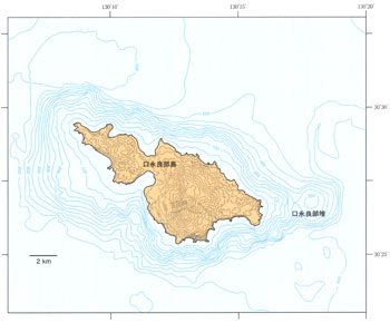
Kuchinoerabujima Volcano is an andesitic stratovolcano located on the volcanic front of Ryukyu Arc and forms Kuchinoerabu Island which is the one of the members of Satsunan Islands. Kuchinoerabu Island is about 13 km long with 6 km across, and 38 km2 in area. The island is the largest volcanic island among Satsunan Islands. The highest point of Kuchinoerabu Island is 657 m a.s.l. and the depth of the surrounding sea is about 500 - 600m. Therefore, the height of the volcanic edifice is about 1200 m from the surrounding seafloor. A seamount 3.5 km across and 420 m high with its summit about 180 m b.s.l. ( named Kuchinoerabu-tai ) exists about 3 km to the east of Kuchinoerabu Island. The island is mostly surrounded by steep cliffs with maximum height more than 200 m and development of beaches is limited within the small bays.
Kuchinoerabu Island consists of many volcanic edifices built from discrete vents in different ages. The central portion of the island consists of Noike, Hachikubo, Furudake and Shindake Volcanoes erupted within the last 15,000 years. These volcanoes have clear summit craters and their flanks were covered by lava flows with fresh original surfaces. Furudake has two collapse scarps opening southward and northwestward.
2.2 Sequence of activities of the volcanoes
Though the beginning of the eruption activity is still unknown, Gokyo Volcano had risen above the sea level around 0.5 Ma. Besides Gokyo, Jogahana Volcano exposed on the northern coast of the island, was formed around 0.5 Ma, and Ban' yagamine Volcano, consisting of the northwestern part of the island, was formed around 0.2 Ma. These volcanoes are oldest volcanic edifices in the island. Following the development of these volcanoes, Takadomori, Kashimine, Noike, Hachikubo, Furudake and Shindake Volcanoes formed in the central - eastern portion of the island. Among them, Takadomori Volcano was formed around 100 ka. The main part of the Noike Volcano was formed before 10 ka. Two large pyroclastic eruptions took place to form Noike and Furudake Volcanoes between 15 and 11 ka.
The eruptions in Holocene occurred mainly in Furudake, Hachikubo and Shindake. Most eruptions are effusion of lava and explosive activities from the summits. All the historical eruptions since 19th century occurred in and around the summit crater of Shindake. Active fumaroles are distributed around the summit craters of Shindake and Furudake.
![]() PREV
PREV ![]() NEXT
NEXT