Kuchinoerabujima Volcano
1: Introduction / 2: Outline of Geology
3: Eruption history
4: Petrology / 5: Historical eruptions / 6:Recent volcanic activities
7: Thermal activities and hot springs / 8: Observations of volcanic activities / 9: Mitigation of disasters
References
![]() PREV
PREV ![]() NEXT
NEXT
7: Thermal activities and hot springs / 8: Observations of volcanic activities / 9: Mitigation of disasters
7: Thermal activities and hot springs
Active fumaroles and solfataras are distributed in and around the summit craters of Furudake and Shindake. The temperature around the 1980 fissure decreased from 342 ?C in 1992 to below 100 ?C after 2000 ( Hirabayashi et al., 2002 ). After the rise of seismic activities in 2002, thermal activities in and around the summit crater of Shindake have increased. Sulfur was mined in this area between 1910s - 1930s.
Many hot springs are distributed in the coastal area. In the western flank of Shindake, submarine hot springs are distributed and sometimes caused discolored sea water. In Nishinoyu, Nemachi and Yumugi areas, hot springs have been utilized as spa.
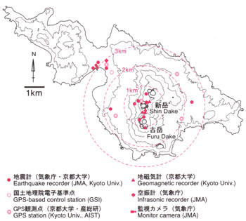
8: Observations of volcanic activities
JMA and DPRI, Kyoto Univ., have been engaged in various geophysical observations since 1999. JMA monitors the seismic activities with four seismometers installed around Shindake. JMA also monitors infrasonic waves and fumarole activities. DPRI, Kyoto Univ., operates seismograph, GPS, and magnetometers around Shindake. Surveys of seismic velocity and magnetic resistively structures have been carried out by DPRI and other institutes. AIST and DPRI monitor ground deformation by GPS network. JMA and JCG repeat the airborne and ground observations. JMA assesses the volcanic activities in six levels ( Level 0 - 5 ). The present activity is Level 2 since February 2005.
9: Mitigation of disasters
The eruptions since 19th century are characterized with strong Vulcanian and phreatomagmatic explosions at Shidake. No remarkable forerunner phenomenon was recorded in the past explosions. Major explosive activities issued magmatic materials and this means that magma head rose to the shallow level beneath the summit crater of Shindake. On the other hand, phreatic eruptions like the 1980 eruption took place without intrusion of magma into shallow depths.
All the historical eruptions since 19th century occurred in and around the summit crater of Shindake. Though no historical record exists, Furudake erupted in 18th century. The pyroclastic flow deposit distributed in Nanakama area was from Furudake crater about 200 years ago.
In the future eruptions, ballistic blocks are expected to be one of the major sources of disaster like it happened in 1930s and 1960-70s activities. Geological studies have revealed that ballistic blocks more than 20 cm across have been scattered over the area up to 3.5 km from craters of Furudake and Shindake and smaller lapilli covered all the areas of the island except for the northwestern part. Small pyroclastic flows were observed with the explosive activities at Shindake and some of them reached flank areas. Volcanic ash sometimes reached Tanegashima and Yakushima Islands. Secondary lahars would occur along the rivers and channels from Shindake.