Kuchinoerabujima Volcano
1: Introduction / 2: Outline of Geology
3: Eruption history
4: Petrology / 5: Historical eruptions / 6:Recent volcanic activities
7: Thermal activities and hot springs / 8: Observations of volcanic activities / 9: Mitigation of disasters
References
![]() PREV
PREV ![]() NEXT
NEXT
4: Petrology / 5: Historical eruptions / 6: Recent volcanic activities
4: Petrology
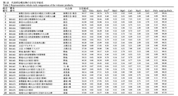
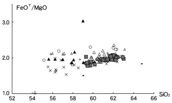
Lavas of Kuchinoerabujima Volcano are pyroxene andesite belonging to calc-alkaline series. Crystals of plagioclase 3 - 4 mm across, and clinopyroxene and orthopyroxene 2 - 3 mm across are contained as phenocrysts. Bulk rock SiO2 contents are in the range of 54 - 62 wt%. Lavas of Takadomori and Kashimine Volcanoes have higher FeOT / MgO ratio compared to other volcanoes of Kuchinoerabujima. Concentrations of K2O against SiO2 have decreased throughout the growth of Kuchinoerabu Volcanoes.
Total SiO2 contents of the Yumugi tephra range from 55 to 62.5 wt% and this variation covers almost the total diversity of the magmas of Kuchinoerabujima Volcanoes. Yumugi tephra contains many banded pumice indicating mixing of mafic and felsic magmas. Total SiO2 contents of Furudake-Megasaki tephra are within the range of 53 and 59 wt%. This is the lowest among the magmas erupted within the last 15,000 years. The products of the younger Furudake and Shindake form a linear compositional trend between 59.5 and 63.5 wt% of SiO2.
5: Historical eruptions
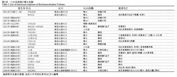
The 1841 eruption is the oldest eruption in historical record. Since then, two active periods 1931-35 and 1966-1980 are recognized. All the historical eruptions occurred from Shindake Volcano ( Iguchi, 2002; JMA, 2005 ).
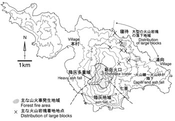
Details of the 1841 eruption are unknown. Ballistic blocks reached Maeda area in the western flank about 3 km from the summit crater.
Level of volcanic activities rose between 1931 and 1935 and some explosions occurred. Ballistic fragments reached Mukaehama area about 2 km from the summit crater. During the night eruptions, spattering of red hot glowing blocks were observed. Forest fires often occurred by the eruptions. These phenomena indicate the emission of high-temperature magmatic materials. Particularly, many high-temperature lapilli hit Nanakama area about 1.7 km from the crater during the eruption of December 25, 1932. This eruption killed 8 people, injured 27, and burned 13 houses in Nanakama area ( Honma 1934, a and b; Matsumoto, 1935; Tanakadate, 1938 ). Some lahars occurred along Mukaehama River in NW flank of Shindake. A large lahar occurred on April, 1935 and hit Mukaehama village. Five people were killed by this disaster ( Tanakadate, 1938 ).
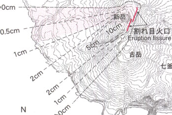
Details of the eruption on November 3, 1945 are unknown. This eruption is considered as phreatic from a fissure opened on the eastern side of Shindake. Some eruptive materials with altered-rocks are distributed locally around the craters.
An explosive eruption occurred on November 22, 1966 from the summit crater of Shindake. Ash fall covered the southern − eastern part of the island and many ballistic fragments were scattered in the northern slope of the island ( Aramaki, 1967 ). Some ballistic blocks reached Nemachi Spa area about 3.5 km north of Shindake crater. Many forest fires started in the northern slope by hot ballistic blocks (Kagoshima Local Metrological Observatory and Yakushima Weather Station, 1967 ). Some minor eruptions took place from Shindake crater during 1970s. These eruptions scattered ballistic blocks and ash fall covered the flank area. An eruption occurred from a fissure formed with the 1945 eruption.
6: Recent volcanic activities
After the 1980 eruption, seismic activities are still active ( Iguchi et al., 2002a ). According to the seismic observations carried out by DPRI, Kyoto Univ., activities were observed in March − June 1996, August - December 1999, and April 2001 - February 2002. Seismic activities have kept at high level since 1999 and some volcanic tremors were detected. The earthquake foci are concentrated between the places 100 - 400 m a.s.l. beneath the summit crater to western slope of Shindake. Episodic inflations centered on the Shindake crater have been detected by GPS since 1995 and the inflation sources were estimated at several 100 m b.s.l. beneath the summit crater of Shindake ( Iguchi, 2002b ). This area corresponds to the minimum zone of the magnetic anomaly ( Utsugi, 2002 ). Temporal change of magnetic anomaly suggests that the increase of temperature in the area beneath the summit crater of Shindake.
Inferred from these geophysical observations, rises of seismic and thermal activities around the summit crater were enhanced by the ascent of hydrothermal fluids from the reservoir at 0.5 km b.s.l. since the 1980 eruption ( Iguchi et al., 2002 ). Seismic swarm and inflation of Shindake were observed in January 2005 ( Saito and Iguchi, 2006 ). The source of inflation was inferred at the point several hundred meters below the summit crater. Fumarolic activities increased after this seismic activity ( Saito and Iguchi, 2006 ).
