3: Eruption history
3.1 Gokyo - Ban'yagamine Stage
Oldest volcanic edifice of Kuchinoerabujima Volcano is Gokyo and Jogahana Volcanoes exposed at the northern coast of the island. Because of the cover by the younger volcanic ejecta, detailed structures of these volcanoes are still unknown. Koseda pyroclastic flow deposit ( 0.58 Ma ) covers Gokyo Volcano.
Ban' yagamine Volcano in the northwestern part of Kuchinoerabu Island consists of some volcanic cones with distinct vents. Volcanic bodies of Ban'yagamine can be divided into Older Ban' yagamine and Younger Ban' yagamine based on the volcanic structures and the development of the hydrothermal alteration. Many landslide structures are recognized in the coastal area.
3.2 Takadomori - Noike Stage
In this stage, Takadomori, Noike and Kashimine Volcanoes were formed. Among them, Takadomori Volcano is the oldest. Takadomori Volcano is an andesitic stratovolcano consisting of lavas and pyroclastic materials.
Kikai-Tozurahara tephra ( Nagase pyroclastic flow deposit) erupted from Kikai caldera 95 ka was found among the volcanic products of Takadomori Volcano. This means that the main part of Takadomori Volcano was built around 100 ka.
Kashimine Volcano in the eastern end of the island forms a volcanic edifice around 256.6 m high peak south of Yumugi. Kashimine Volcano sits on the flank of Takadomori Volcano. Growth of Kashimine Volcano finished around 50 ka.
Noike Volcano is an andesitic stratovolcano developing on the western flank of Takadomori, and occupies the central portion of the island between Takadomori and Ban' yagamine. Main part of Noike Volcano is covered by Aira-Tn tephra ( 29 ka ).
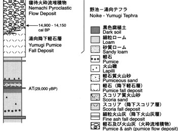
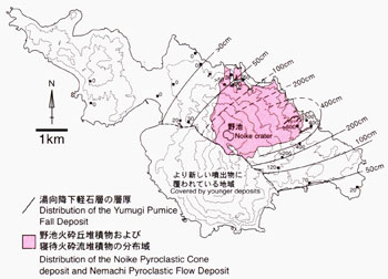
A large eruption occurred from the summit of Noike around 15 ka depositing Noike-Yumugi tephra. Noike-Yumugi tephra consists of pumiceous deposit and can be divided into Noike pyroclastic cone deposit at the summit, Yumigi pumice fall deposit, and Nemachi pyroclastic flow deposit in the northern − eastern flanks of the island. Yumigi pumice fall deposit erupted prior to Nemachi pyroclastic flow. Its maximum thickness is more than 3 m at about 3 km east of the vent. The distribution axis of Yumigi pumice fall deposit is located towards NNE from the summit crater of Noike. Nemachi pyroclastic flow deposit widely covers the north - northeastern flanks of Noike while small branches are also recognized in the western flank. Nemachi pyroclastic flow deposit is a pumice flow deposit. Around Nemachi spa in the northern coast, the Nemachi pyroclastic flow deposit is strongly welded. In the non-welded part, pumices up to several 10s of cm are included without fine-grained matrix. Noike pyroclastic cone deposit consists of poorly-sorted pumiceous deposit and the inside of the Noike pyroclastic cone is strongly welded.
Volume estimation of the tephra is ambiguous because of the distribution of Noike-Yumigi tephra extends into the sea area. Total volume of the tephra is estimated roughly at 0.6 km3 or more. Noike pyroclastic cone deposit is 0.23 km3, Nemachi pyroclastic flow deposit 0.20km3, and Yumugi pumice fall deposit 0.18 km3 or more.
After the eruption of Noike-Yumugi tephra, activities of Noike declined. Small phreatic activities occurred on the eastern flank of Noike and minor tephra deposits consisting now of clay and altered rock fragments were produced.
3.3 Furudake - Shidake stage
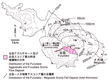
Older Furudake Volcano began its activity around 13 ka on the southern flank of Noike. A series of scoria eruptions of basaltic andesite occurred between 13 and 11 ka from the position of the present central crater of Furudake. Products of this eruption were named Furudake - Megasaki tephra. This eruption also formed a pyroclastic cone consisting of agglutinate on the southern flank of Noike. Furudake scoria flow deposit was distributed around the pyroclastic cone. Scoria fall ( Megasaki scoria fall deposit 1 and 2 ) covered eastern part of the island. Total volume of the erupted materials is estimated to be about 0.6 km3.
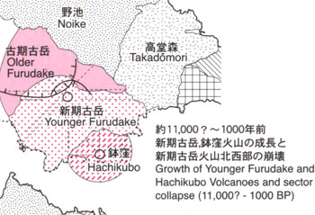
The pyroclastic cone of Older Furudake collapsed in the south and the younger Furudake began growth inside the collapsed scarp. Age of the oldest tephra observed on the present surface of younger Furudake is about 4.5 ka. This implies that the present edifice of younger Furudake had already been built around 4.5 ka. Minami-Nanakama lava and Hiratoko lava were erupted between 4.5 and 2.0 ka. Vulcanian-type eruptions repeated from the summit of Furudake. These activities produced explosion breccia deposits around the summit area and formed a pyroclastic cone ( younger Furudake pyroclastic cone deposit 1 and 2 ). A part of the pyroclastic deposit flew down as block-and-ash flow (younger Furudake pyroclastic flow deposit 1 and 2 ). The youngest product of Furudake is Nanakama pyroclastic flow erupted around 200 years ago. Nanakama pyroclastic flow deposit is distributed on the eastern flank of Furudake and contains essential blocks more than 1 m across. The typical thickness of the deposit 2 km from the summit crater is about 1m.
Hachikubo Volcano is a small stratovolcano sitting on the southern flank of Furudake. Activity of Hachikubo Volcano is simultaneous with the growth of younger Furudake.
A partial collapse of younger Furudake occurred around several thousands years ago and Shindake Volcano began growth inside the collapsed scarp. Shindake consists of a group of lavas erupted in 9th or 11th centrury ( Shindake lavas, Miki et al., 2002 ) and a pyroclastic cone caps on the summit of Shindake. Shindake lava consists of at least three flow units. Shindake pyroclastic cone consists of explosion breccia, which is the products of Vulcanian and phreatic - phreatomagmatic activities from the summit crater of Shindake. In the flank area, the ejecta occur as block-and-ash flow deposit. A central crater with ca 250 m across exists at the summit of Shindake and some satellite craters with 10 - 100 m across are distributed around the central crater. Some of the satellite craters were opened during the 1930s activities ( Tanakadate, 1938 ).
A fissure with ca 500 m in length running N-S direction opened on the eastern slope of Shindake, from which the 1945 and 1980 eruptions occurred. Lahar deposits are distributed along channels from Shindake. Lahar deposits which caused disaster of 1931 to 1935 are distributed along Mukaehama River ( Tanakadate, 1938 ).
Fallout deposits associated with the growth of younger Furudake and Shindake are distributed all the area of the island. Distribution of this tephra indicates that the Vulcanican and phreatomagmatic eruptions repeated at the summit of Furudake and Shindake. Ballistic blocks with impact crater are distributed in the area within ca 3 km from the summit craters of Furudake and Shindake. Some of these blocks have radial cooling joints indicating that they are essential ejecta. No pumiceous deposit indicating directly derived from magmatic source is found in the pile of tephra.
Koya pyroclastic flow deposit erupted from Kikai Caldera around 7.3 ka covers all the area of island except for Shindake and younger Furudake. This pyroclastic flow deposit consists of pumiceous volcanic ash.
Typical thickness of the deposit is less than 1 m.