日本の火山 > 第四紀火山 > 個別火山 > 画像集 > 画像
Volcanoes of Japan > Quaternary Volcanoes > Volcano > Photo Gallery > Image
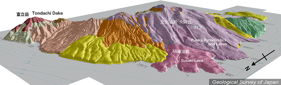
諏訪之瀬島 ______ Suwanose Jima |
地質陰影図(北西→南東、15°)。山頂部南西側に広がる文化溶岩・火砕丘(紫色)は1813年の噴出物。須崎溶岩も新期の火山噴出物であるが、それ以外の富立岳火山(左)やナベダオ火山(右)はより古い山体である。 |
|||
| 地質図:嶋野岳人ほか(2013)諏訪之瀬島火山地質図。火山地質図17、産総研地質調査総合センター。 | |||
Topographic relief of Suwanosejima combined with geological map (tilted by 15° from the NW to the SE). The Bunka pyroclastics and lavas (purple-colored) are distributed around from the summit area to the western coast. Both the Tondachidake Volcano (left end) and the Nabedao Volcano (right end) are the oldest volcanic products. |
|
| Geological Map: Shimano et al. (2013) Geological map of Suwanosejima Volcano. Geological map of volcanoes, no.17, Geological Survey of Japan, AIST. | |