日本の火山 > 第四紀火山 > 個別火山 > 画像集 > 画像
Volcanoes of Japan > Quaternary Volcanoes > Volcano > Photo Gallery > Image
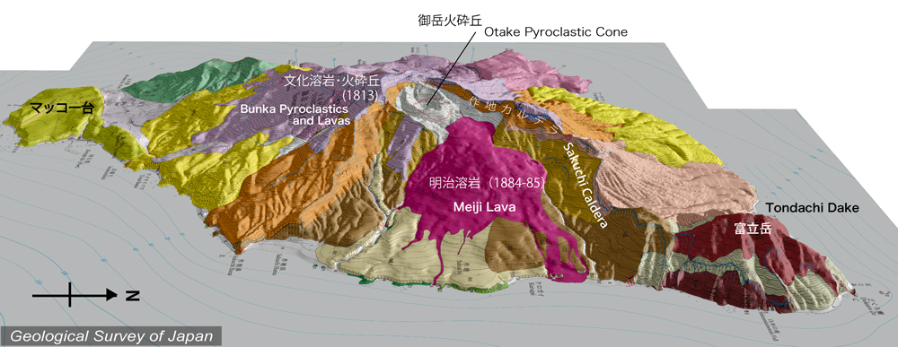
諏訪之瀬島 ______ Suwanose Jima |
地質陰影図(東→西、25°)。諏訪之瀬島東部に作地カルデラがあり、その西端に活動中の御岳火口がある。カルデラ内の明治溶岩(赤色)は1884-85年の噴出物。カルデラ南西側に広がる文化溶岩・火砕丘(紫色)は1813年の噴出物。カルデラ形成は文化時代の噴火の末期。 |
|||
| 地質図:嶋野岳人ほか(2013)諏訪之瀬島火山地質図。火山地質図17、産総研地質調査総合センター。 | |||
Topographic relief of Suwanosejima combined with geological map (tilted by 25° from the E to the W). The Sakuchi Caldera was formed at the end of 1813 eruption (Bunka Eruption). The Bunka pyroclastics and lavas (purple-colored) occupy outside slope of the caldera. The youngest lava, Meiji Lava (red-colored), erupted in 1884-85 is distributed inside the caldera. |
|
| Geological Map: Shimano et al. (2013) Geological map of Suwanosejima Volcano. Geological map of volcanoes, no.17, Geological Survey of Japan, AIST. | |