日本の火山 > 第四紀火山 > 個別火山 > 画像集 > 画像
Volcanoes of Japan > Quaternary Volcanoes > Volcano > Photo Gallery > Image
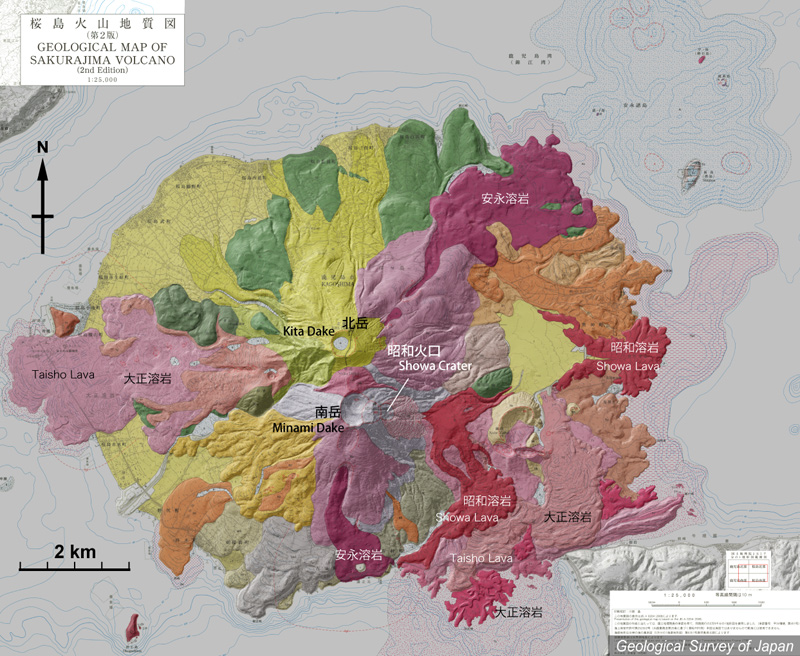
桜島 ______ Sakurajima |
地質陰影図。山頂部に北岳(上)と南岳(下)の二つの火口がある。現在活動中は南岳。山頂火口のほか、昭和火口で活動が続く。南東に1914-15年の大正溶岩が広がり、大隅半島と陸続きになっている。山頂部の西の側火口からも大正溶岩が流出。東側では大正溶岩の上を1946年の昭和溶岩が覆う。山頂から北東や南の側火口から流下している溶岩は1779年の安永溶岩。大正溶岩と安永溶岩は海中に流入している。 |
|||
| 地質図:小林哲夫ほか(2013)桜島火山地質図(第2版)。火山地質図1、産総研地質調査総合センター。 | |||
Topographic relief of Sakurajima combined with geological map. Summit craters comprise northern Kita Dake and active southern Minami Dake. The Taisho Lava that covered the W and the SE flank, bridge the island and the mainland. They are overlain by the Showa Lava. The An'ei Lava erupted from lateral craters located northeast and south of the summit. The An'ei and Taisho Lavas both flowed into the sea. |
|
| Geological Map: Kobayashi et al. (2013) Geological map of Sakurajima Volcano (2nd Edition). Geological map of volcanoes, no.1, Geological Survey of Japan, AIST. | |