日本の火山 > 第四紀火山 > 個別火山 > 画像集 > 画像
Volcanoes of Japan > Quaternary Volcanoes > Volcano > Photo Gallery > Image
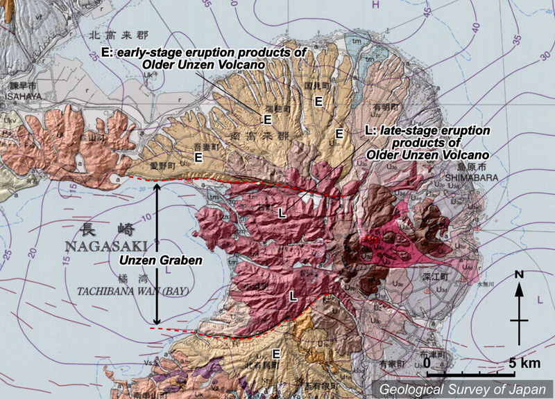
雲仙岳 ______ Unzen Dake |
SM |
|
地質陰影図。島原半島の中央に、正断層に区切られた雲仙地溝帯が東西に延びる。地溝帯の外側には古期雲仙火山の前期の噴出物(淡薄茶色)、地溝内の西半分には古期雲仙火山の後期の噴出物(ピンク色)が広く分布する。雲仙岳は半島の中心部にある。 |
|
|
|
| 地質図:星住英夫ほか(2004)20万分の1地質図幅「熊本」、産業技術総合研究所地質調査総合センター。 | |||
Topographic relief of Shimabara Peninsula combined with geological map showing Unzen Graben in the center of peninsula, extending E-W. Unzendake developed in the center of the peninsula. Early Older Unzen eruptive products (E) distributed outside the graben. Younger Older Unzen eruptive products (L) distributed on the western half, inside the graben. |