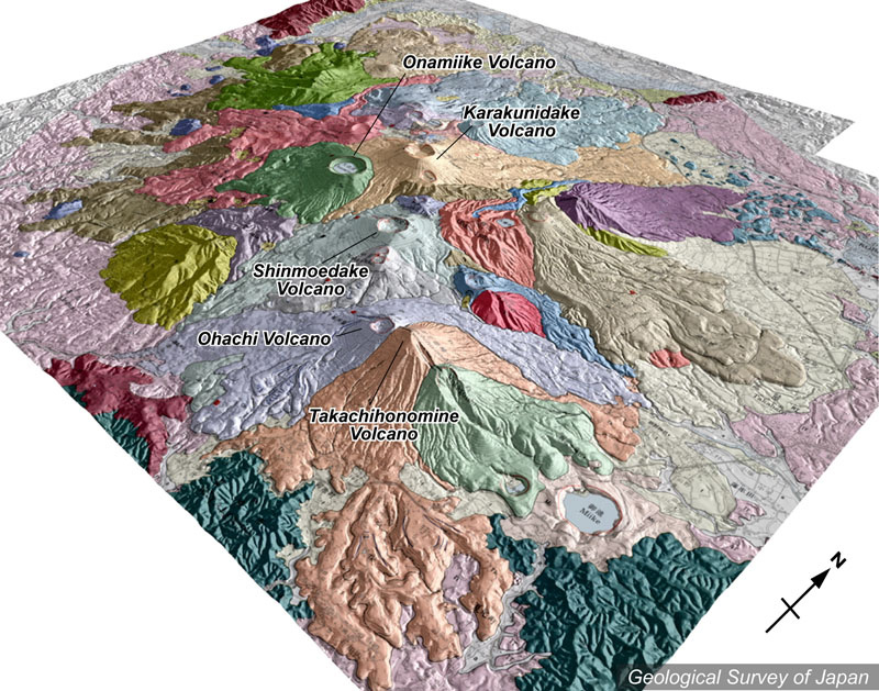
地質陰影図(南東→北西、40゜)。手前のピークが高千穂峰火山(肌色)。それを覆って御鉢火山(淡紫色)。ほぼ中央に韓国岳火山(淡肌色)と火口湖を持つ大浪池火山(淡緑色)。火口地形が明瞭な火山では、いずれも山麓の溶岩流微地形が目立つ。高千穂峰の右手前(東)の御池は約4200年前に形成されたマール。 |
|
|
|
| 地質図:井村隆介・小林哲夫(2001)霧島火山地質図。火山地質図11、地質調査所。 | |||
Topographic relief of Kirishima Volcano Group combined with geological map (tilted by 40° from the SE to the NW). Takachihonomine Volcano (pale pink) in the foreground is covered by Ohachi Volcano (pale purple). Karakunidake (pale orange) and Onamiike (pale green) volcanoes in the center. Note microtopography of lava flows on the flank of many volcanic edifices with well-defined crater shape. Miike Maar on the eastern flank of Takachihonomine Volcano was formed 4200 years ago. |
K. Nakajima |