Underground structure
火山研究解説集:薩摩硫黄島 (産総研・地質調査総合センター作成)
| Contents: Satsuma-iojima |
|---|
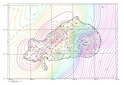
- Gravity anomaly of Iojima
Introduction
Geophysical prospecting is one of the powerful methods to study underground structure of a volcano. Results of a contract research, ‘Feasibility study of power generation method on a volcano’ carried out from 1975 to 1977 by Japan Electric Machine Industry Association in the Sunshine Project of Industrial Science and Technology Agency, are summarized below. The results were published partly in Geological Survey of Japan (1976 and 1980).
Also introduced is a study of spontaneous potential observations (Kanda and Mori, 2002). Although not referred to in this document, regional magnetic anomaly distribution was studied by Geological Survey of Japan (1980).
Summary of the survey
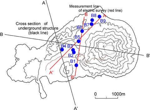
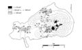
- Survey points and observation lines of electrical exploration
Electrical resistance, density, and magnetic susceptibility (induced magnetic strength of a material by magnetic field) vary on the type of earth material. Underground structure can be deduced from measurements of these.
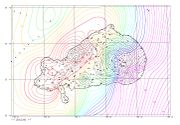
In Iojima, measurements at drill holes of about 100 m depths, electrical survey at mountain foot areas, gravity measurements, spontaneous potential survey, and aeromagnetic survey have been carried out. Locations of drill holes, measurement lines for electrical survey, positions of cross sections of magnetic and gravity analyses are shown in the upper figure (Locations of measurements and electrical survey lines).
From the measurements at drill holes, data on groundwater levels and temperatures at the bottoms of the holes are obtained. Drill hole bottom temperature represents ground temperature at that depth.
In electrical prospecting an electric current is passed between a pair of electrodes, and electrical resistance of the ground is measured. Underground structure below the line connecting observation points can be deduced from the data obtained.
In gravity survey, densities of underground materials are known from surface gravity values.
In magnetic survey, magnetic susceptibilities of underground materials are known from the measurement at the ground surface. For the following detailed descriptions, measurements were carried out with air-borne instrument installed in an aircraft.
Survey utilizing drill holes
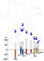
Groundwater level and drill hole bottom temperature for each hole are shown in a diagram (Groundwater level and drill hole bottom temperature). Groundwater is partially derived from permeated rainwater, but the level is influenced from the ease of underground flow. If flowing is difficult the level would rise and vice versa. At Iojima the groundwater level is roughly equal to the level of sea and seems to flow easily.
On the other hand, bottom temperature is not uniform. A high temperature suggests existence of possible heat source.
Electrical explorations
Specific resistance is measured in electrical prospecting. The specific resistance is a measure of ease for electric current to flow, and the larger the value the more difficult for current to flow. Underground specific resistance values depend on the types of rocks, existence of fresh groundwater and sea water, and temperature. Specifically, in the volcanic areas, specific resistance may become anomalously small if water contents of the rocks are high or alteration of rocks is advanced. Therefore, measurements of specific resistance give good information for the underground structure.
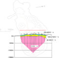
Diagrams shown below (Specific resistance (Cross section A) and specific resistance structure (Cross section B)) were obtained with an electrical prospecting method called Shlumberger method and show underground structure of Iojima based on specific resistance. It shows that in Iojima specific resistance below groundwater level is anomalously low at 1-4Ω・m. The two reasons why it is so may be due to existence of permeated seawater under Iojima and widespread development of volcanic alteration of rocks.
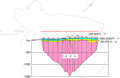 Cross section of specific resistance along a line (Cross section A) |
 Cross section of specific resistance along a line (Cross section B) |
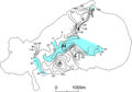
Gravity survey
Distribution of gravity anomaly obtained through gravity measurements reflects the differences of densities of underground materials.
Data shown by Komazawa et al. (2005) indicate that the gravity of Iojima tends to decrease from NW to SE directions. This is interpreted as reflecting structure of caldera. That is, the materials filling the depression of caldera have lower densities than those of surrounding areas and the filling materials tend to thicken from NW to SE of the island.
Magnetic and density structures
Earth’s magnetic field is locally disturbed as magnetic characteristics of rocks are different from place to place. The difference between standard value of magnetic strength and local strength is called magnetic anomaly. An estimation of underground structure is possible from the magnetic anomaly. The magnetic anomaly can be measured from an aircraft to obtain more generalized figure.
Air-borne magnetic anomaly survey was carried out near Iojima, and together with the gravity anomaly data underground structure was estimated along two cross sections (See Analyzed cross section A and Analyzed cross section B below). In practice, rock bodies with different magnetic strengths (shown in blue) and density contrasts (shown in red lines) are recognized.
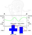 Cross section for magnetic anomaly and density structure along line A-A’ |
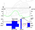 Cross section for magnetic anomaly and density structure along line B-B’ |
Survey on spontaneous potential
Spontaneous potential is naturally occurring electric potential in the earth and shows anomaly reflecting movement of groundwater or ground hot water. Spontaneous potential is measured with electrodes set up on the ground surface. As measuring method is simple, it has been used in prospecting of ores and hot springs.
Where underground water flows immediately below the ground surface, upstream side tends to show positive potential while downstream side negative. In mountainous region, the higher the altitude the lower the potential and this is called topographic effect. It is due to water flowing down from the summit to the foot.
On the other hand, anomalies in spontaneous potential occur with the thermal water flow: Where thermal water rises positive anomaly and where it descends negative anomaly would appear. Anomaly does not occur with the movement of volcanic gas or steam. The size of anomaly varies depending on the specific resistivity of the rock. If the rock has low specific resistivity (better conductor) the amplitude of anomaly tends to be small and vice versa.
The diagrams below show the results of measurements of spontaneous potentials in Iojima for 1975 and 1999. Both diagrams show positive anomaly on the western flank of Iodake. This may represent flow of underground water. In the diagram for 1999, positive anomaly was observed at the summit area probably suggesting movement of thermal water accompanying fumarolic activity.
 Distribution of spontaneous potential (1975) |
 Distribution of spontaneous potential (1999) |
References
Geological Survey of Japan (1976) Report of geothermal basic survey in Japan, No. 3 Nansei Shoto, 90p. Geol. Surv. Japan.
Geological Survey of Japan (1980) Total intensity aeromagnetic map, No. 25-1 Coast of Osumi Peninsula-Yakushima Area, Scale 1:200,000, Geol. Surv. Japan.
Kanda, W. and Mori, S. (2002) Self-potential anomaly of Satsuma-Iwojima volcano. Earth Planets Space, vol.54, p.231-238.
Komazawa, M., Nawa, K., Murata, Y., Makino, M., Morijiri, R., Hiroshima, T., Yamazaki, T., Nishimura, K. and Okuma, S. (2005) Gravity map series (bouguer anomalies), No.22 Gravity map of Yaku Shima district, Scale 1:200,000, Geol. Surv. Japan.
(Nobuo MATSUSHIMA)