Sakurajima Volcano - 2nd Edition -
Introduction / Geology of the Area around Sakurajima Volcano / Summary of the Topography and Geology of Sakurajima Volcano
Eruption History of Sakurajima Volcano
Historical Eruptions
Volcanic Rocks of Sakurajima Volcano
Monitoring and Observation of Volcanic Activity / Forecasting of Future Activity
Appendix: Revisions from First Edition
References
![]() PREV
PREV ![]() NEXT
NEXT
Introduction / Geology of the Area around Sakurajima Volcano / Summary of the Topography and Geology of Sakurajima Volcano
Introduction
Sakurajima Volcano in Kagoshima Prefecture is one of the most active volcanoes in Japan. Explosive eruptions have been occurring at the Minamidake crater on Sakurajima' s summit almost continuously since 1955. In 2006, the activity at the Showa crater restarted and currently explosive eruptions occur almost daily. Historically, Sakurajima has repeated large-scale eruptions including the Taisho eruption around 100 years ago. In order to understand the volcanic activity at Sakurajima, its origin must be known and a highly accurate geological map of the volcano that serves as a chart of past volcanic eruptions must be created. The overall geology of Sakurajima Volcano was first mapped out by Yamaguchi (1975). After this, a first edition of a geological map of the volcano was published in 1981 (Fukuyama and Ono, 1981) based on the results of Fukuyama (1978). Over the next 30 years, the amount of data on the geology of Sakurajima grew compared to what was in the first edition in 1981. Data included new geologic maps published by Kobayashi (1988), radioactive dating of tephra performed by Okuno (1997; 2002), lava dating by paleomagnetism (Miki, 1999), and boring core analysis (Uto et al., 1999) to name a few. In the second edition, a major revision is being conducted based on these findings and the corrections are summarized in an appendix.
Geology of the Area around Sakurajima Volcano
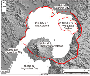
Kagoshima Bay where Sakurajima sits is a narrow bay 70 km long (north-south) and 20 km wide (east-west) with sheer cliffs bounding both its east and west sides. Kagoshima Bay and the area around Kirishima Volcano to the north of the bay are called the Kagoshima graben, as it is formed by Quaternary subsidence along normal faults extending north to south. Aira Caldera is located in the inner Kagoshima Bay with Sakurajima at its southern edge; it extends about 20 km across and is a basin-shaped depression (![]() Fig. 1).
Fig. 1).
Over the last 100,000 years, Aira Caldera has seen at least four Plinian eruptions and two large-scale pyroclastic flow eruptions (Nagaoka, et al., 2001). In addition, inside Aira Caldera on its northeastern half lies the nearly 5 km wide, submarine Wakamiko caldera 200 m below the water surface. This caldera exhibits active submarine fumarolic activity on a constant basis, so it is recognized as an active volcano.
The last large-scale eruption in Aira Caldera (29,000 years ago) started with a pumice eruption (Osumi Pumice Fall) followed by the large-scale Ito Pyroclastic Flow. The ejecta from these consecutive episodes are collectively known as the Aira-Tn Tephra and the volume of tephra expelled is estimated at around 500 km3 (Machida and Arai, 2003). Sakurajima Volcano sits near the southern edge of Aira Caldera and started its growth about 26,000 years ago, 3000 years after the caldera eruption ended. The small plateau at Hakamagoshi on the west side of Sakurajima is a part of the outer rim of the caldera and consists of the Middle Pleistocene Kekura Formation and other marine deposit formations accumulated in the Kagoshima graben. The surface layer is covered by the Aira-Tn Tephra.
Summary of the Topography and Geology of Sakurajima Volcano
Sakurajima Volcano is composed of two stratovolcanic overlapping cones: Kitadake the older, and Minamidake, the younger with Nakadake as a lateral vent of Minamidake. Sakurajima stretches 12 km east-west and 9 km north-south. The three craters at the center: Kitadake, Nakadake and Minamidake line up north to south. Originally it was a volcanic island and lava flow from the Taisho eruption about 100 years ago filled the strait between Sakurajima and the Osumi Peninsula connecting Sakurajima with Kyushu.
The main stratovolcanic body Kitadake consists of interbedded lavas and pyroclastic rocks. Lava flows exhibiting prominent lava scarps are distributed from the base of the volcano to its sides. The last eruption at Kitadake was a pumice eruption that blanketed the terrain around the Kitadake summit with a thick layer of pumice. The north slope of the summit in particular, exhibits minor secondary flows of welded pumice layers. In addition, a wide alluvial fan has been formed at the northwest foot. There is a lateral vent of Gongenyama Lava at its east foot, and lateral vents of Harutayama and Hikinohira Lavas at its west foot.
The Minamidake main stratovolcano is dominated by its lava. Its formation history is subdivided into older and younger periods. The lavas in the older period of Minamidake were highly fluid and are widely distributed over the east and south foots of the mountain. Whereas, the viscosity of the lavas in the younger period were slightly higher resulting in irregular forms containing relatively large lava wrinkles and levees. At the downriver section of Nojirigawa on the west foot of the mountain and Jigokugawara at the east foot of the mountain, alluvial fans are currently being formed. The Nabeyama Pyroclastic Cone at the east foot of the mountain is one of the lateral vents on Minamidake and is a typical tuff cone created by phreatomagmatic eruptions. Furthermore, in the waters off the northeast coast, there is a cryptodome that has been lifted to about 100 m from the seafloor as a result of the magma intrusion into it during the An-ei eruption.
![]() PREV
PREV ![]() NEXT
NEXT