Sakurajima Volcano - 2nd Edition -
Introduction / Geology of the Area around Sakurajima Volcano / Summary of the Topography and Geology of Sakurajima Volcano
Eruption History of Sakurajima Volcano
Historical Eruptions
Volcanic Rocks of Sakurajima Volcano
Monitoring and Observation of Volcanic Activity / Forecasting of Future Activity
Appendix: Revisions from First Edition
References
![]() PREV
PREV ![]() NEXT
NEXT
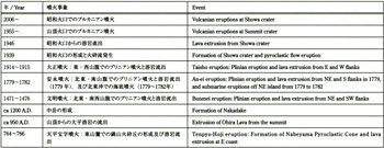
Historical Eruptions
The oldest recorded eruption of Sakurajima Volcano dates back to the year 708 AD. Since then, while a number of records of subsequent eruptions exist, excluding four large-scale eruptions, many of the other records are fragmented and are not well understood. The large-scale eruptions are the Tenpyo-Hoji, Bunmei, An-ei, and Taisho eruptions (![]() Table 1). Their first stage began with a plinian-style eruption from the volcano' s flank resulting in a pumice fall (
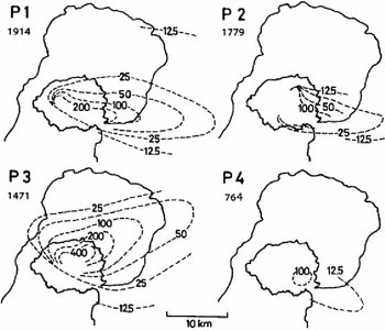
Table 1). Their first stage began with a plinian-style eruption from the volcano' s flank resulting in a pumice fall (![]() Fig. 5) and tended to end with a final outflow of lava. After the Tenpyo-Hoji eruption, there is no record of another eruption until the Bunmei eruption 700 years later. It is unclear whether or not eruptions actually occurred within this timespan. However, it was confirmed from the ejecta (Ohira lava, Nakadake lava and pyroclastic rock) that there was an eruption followed by an outpouring of lava from the mountain summit or close to it around 950 and 1200 (Kobayashi, et al., 2009; Kobayashi, 2010; Miki et al., 2012). The stratigraphy and petrological characteristics of Nakadake in particular reveal the eruption of the lateral vent during the Younger Minamidake (Yamaguchi, 1975), and carbon dated volcanic sands of about ca. 800 cal yr BP (Sz-Nk;
Fig. 5) and tended to end with a final outflow of lava. After the Tenpyo-Hoji eruption, there is no record of another eruption until the Bunmei eruption 700 years later. It is unclear whether or not eruptions actually occurred within this timespan. However, it was confirmed from the ejecta (Ohira lava, Nakadake lava and pyroclastic rock) that there was an eruption followed by an outpouring of lava from the mountain summit or close to it around 950 and 1200 (Kobayashi, et al., 2009; Kobayashi, 2010; Miki et al., 2012). The stratigraphy and petrological characteristics of Nakadake in particular reveal the eruption of the lateral vent during the Younger Minamidake (Yamaguchi, 1975), and carbon dated volcanic sands of about ca. 800 cal yr BP (Sz-Nk; ![]() Fig. 2) are considered to correlate to this formation (Kobayashi, 2010). The historical accounts of the eruptions below are primarily taken from Kobayashi and Tameike (2002).
Fig. 2) are considered to correlate to this formation (Kobayashi, 2010). The historical accounts of the eruptions below are primarily taken from Kobayashi and Tameike (2002).
Tenpyo-Hoji Eruption (764 to 766 AD)
The Tenpyo-Hoji eruption occurred at the east foot of Minamidake; the Nabeyama Pyroclastic Cone was formed and the Nagasaki-hana Lava then flowed over the seaward side of Nabeyama. The Nabeyama Pyroclastic Cone is a tuff cone with a very wide crater typical of phreatomagmatic eruptions. Its ejecta are composed of polyhedral pumice fragments and volcanic ash, and are also rich in obsidian flakes as a result of rapid cooling. At the time of the eruption, Nabeyama emerged near the coast. As a result, during and immediately following its formation, the waves eroded away the eastern half of its cone. The Nagasaki-hana Lava was distributed as if it spread out from the base of the pyroclastic cone meaning that the lava flow occurred after the pyroclastic eruption. Lava-like topography extending to the northeast has been observed on the seabed off the coast of Kurokami, but it is believed to be lava formations that flowed onto the seafloor (or intruded into the seabed). Furthermore, a small pyroclastic cone (Ebinotsuka) adjacent to the east side of Nabeyama was generated at the time of the eruption. There is a record that many of the island' s residents evacuated due to the swarm of earthquakes in 766 AD. The eruptive magma volume that consists of a combination of pyroclastic deposits and lava is approximately 0.3 km3 Dense Rock Equivalent (DRE) and is small compared other with large-scale eruptions thereafter.
Bunmei Eruption (1471 to 1476 AD)
The Bunmei eruption occurred mainly at the crater chain that appeared on the northeastern and southwestern slopes of Minamidake. Judging by the plinian-style eruptions and topography, it turns out that the lava eruption at the crater on the northeast slope came in 2-stages whereas, lava erupted from the crater chain flank at the southwest foot of Sakurajima, and at the tip of the alluvial fan near its foot. The lava that erupted from crater at the tip of the alluvial fan reached all the way to the sea. Furthermore, the Bunmei Lava was observed to have gone all the way down to the foot of south-southwest slope (Takahashi et al., 2011), but the location of the crater from which this lava emerged is unclear.
The Bunmei eruption was the largest plinian-style eruption in historical times. Its pumice layer (![]() Fig. 5 (P3)) is thicker than any other laid down during this period. The total amount of magma erupted has been estimated to be approximately 0.8 km3 DRE. Historical documents claim that there were multiple eruptions over six years, but this is hard to verify because not all of the ejecta from that eruptive period have been identified. It has been documented that there was also a huge amount of damage from the eruptions, but the extent is unclear.
Fig. 5 (P3)) is thicker than any other laid down during this period. The total amount of magma erupted has been estimated to be approximately 0.8 km3 DRE. Historical documents claim that there were multiple eruptions over six years, but this is hard to verify because not all of the ejecta from that eruptive period have been identified. It has been documented that there was also a huge amount of damage from the eruptions, but the extent is unclear.
An-ei Eruption (1779 to 1782 AD)
The An-ei eruptions include eruptions at the southern slope of Minamidake, later at the northeast slope, and a submarine eruption off the northeast coast. The eruption was preceded by a significant number of precursors including earthquake swarms, increase in water pouring out from wells, boiling water in wells, and seawater discoloration.
The plinian-style eruption began on the south and northeast sides of Sakurajima on November 8, 1779 AD. The crater on the south side generated a pyroclastic flow in the early stage of the eruption. The following morning, the plinian-style eruption was at its most violent, forming agglutinates of pyroclastic flow deposits and welded pyroclastic fall around the crater. The tip of the agglutinates flowed out and had slightly reshaped Sakurajima' s topography. Lava from the crater on the south side did not erupt from the highest crater; instead it came from a crater halfway up the mountain (500 to 600 m above sea level). Furthermore, the small crater chain at the foot of the mountain aligns in a slightly oblique direction with a major fissure whereas, at the northeast side of the crater lava crept into the base of the agglutinates, deforming and fracturing them and then partially flowed out from around the base of the agglutinates.
More than a year later submarine eruptions occurred off the northeast coast of Sakurajima forming new islets called the An-ei Islands (Kobayashi, 2009). When the submarine eruptions occurred, first there was a giant pumice eruption. Later, a cryptodome, which became an obvious projection on the seafloor, grow; over the next year and a half, islands were formed.
Four of the An-ei islands still remain. Inokojima and Iojima are two of the islands formed when the An-ei Lava erupted from the seafloor. Nakanoshima and Shinjima islands were uplifted and emerged from the seafloor. The uplifted islands are studded with giant pumice that has been deposited on their surface. Also, Shinjima has near-surface marine sediments that contain fossil shells and has also clearly retained topographic fault features that occurred during its uplift. All of the An-ei Islands emerged almost at the same time; so, the submarine explosions were tremendous and resulted in damaging tsunamis.
The number of tsunamis that were documented is six. Three came after an submarine explosion. In April 1781 AD for example, the tsunami generated by explosive eruptions swept away fishing boats, produced waves as high as 10 meters that resulted in 20 people dead or missing. The An-ei eruption claimed 153 lives, mainly in villages along the southern and southeast coast of the island where nearly all of the pumice fall and pyroclastic flow were deposited. The total amount of magma from the An-ei eruption is estimated to be about 2.0 km3 DRE. If the part of the magma that penetrated the seafloor cryptodome is included, the volume would be greater still.
Taisho Eruption (1914 to 1915 AD)
Before and after Sakurajima' s Taisho eruption, there were earthquakes and volcanic activity throughout southern Kyushu. In 1914 AD, earthquakes and volcanic activity were experienced in the Kirishima region. But, in the early morning on January 11th, earthquakes started to be felt at Sakurajima. Around 10:05 am on the 12th, a plinian-style eruption began from a fissure on the west flank; after about 10 minutes an eruption began on the east flank.
This plinian-style eruption lasted more than a day and a half, and a M7.1 earthquake struck Kagoshima City that evening at 18:29, killing 35 people. By the 13th, the eruption had weakened, but that evening at 20:14 there was another eruption at the western crater with a violent pyroclastic flow that appeared to burn bright red over the entire west side of the mountain.
Lava had flowed out following this eruptive explosion, and was discharged during repeated minor eruptive explosions, but it dropped off substantially after about two weeks. In contrast, the lava that flowed out of the fissure on the east side filled the Seto Strait on January 30th and connected Sakurajima to the Osumi Peninsula (Taisho Lava: Stage I); by February new lava flowed from the eastern crater and continued to do so for about one and a half years (Taisho Lava: Stage II).
From March to April 1915 secondary lava drained out mainly from the front of the primary lava flow thus forming a lava delta. The total amount of magma erupted in the Taisho eruption is estimated to be 1.5 km3 DRE. After the eruption, land sank concentrically around Aira Caldera. Land sinking of around 30–50 cm was also observed around Kagoshima City.
Immediately after the eruption, papers and reports on the crater locations of the western Taisho lava zone were written, but the distribution of crater locations did not match exactly. As Ueda (1914) provides the most detailed geological map, we will use it as a reference. In addition, we will use Omori (1914) as a reference as it illustrates eight eastern crater locations.
Volcanic Activity after the Taisho Eruption
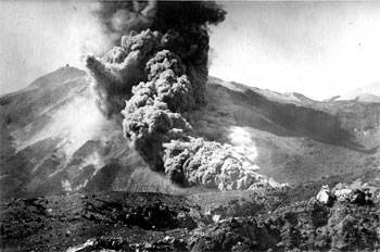
After the Taisho eruption, Sakurajima remained quiet for some time. In 1939 AD however, there was another eruption on the eastern slope of Minamidake' s crater rim that produced a minor pyroclastic flow (![]() Fig. 6).
Fig. 6).
The chemical composition of the ejecta from this eruption at Sakurajima Volcano was the most mafic (SiO2: 57 wt.%). Seven years later in 1946 AD, another eruption occurred from the same crater that issued the 0.18 km3 Showa Lava. These were no large-scale pumice eruptions, but there were vulcanian-style eruptions that formed pyroclastic cone-shaped geologic features. The Showa Lava forked off in two directions at a nearby plateau and created by the eastern Taisho lavas.
The first leg of the lava flowed in an easterly direction and the second leg flowed south-southwest; both reached the shoreline.
Since 1955 AD, eruptive activity has intensified at the summit crater of Minamidake. The eruptions are vulcanian in nature and violent. In 1985 AD Minamidake had 474 explosive eruptions. The frequency of the explosive eruptions fluctuated repeatedly, but since 2000 the numbers of explosive eruptions have decreased. In particular, the number of eruptive explosions fell dramatically starting in 2003 AD. However, on June 4, 2006 AD, a sudden explosive eruption occurred again at the Showa crater. Eruptive activity had ended after about two weeks, but within that time a minor pyroclastic flow had also taken place.
Minor eruptive activity began again the following year on May 16, 2007 AD, but ended after about a month. While there were few eruptive explosions during 2008 AD, a red hot glowing phenomenon could often be seen on the mountain slope immediately following the explosions In 2009 AD, the level of activity increased dramatically and beginning in the second half of the year the frequency of vulcanian-style eruptive explosions quickly increased. There were 896 explosive eruptions in 2010 AD and 996 in 2011 AD. This pattern shows that the number of eruptive explosions has more than doubled since the 1980s, but the scale of each eruption is much smaller than those that occurred in the 1980s.
Prior to resuming activity, the Showa crater was a depression on a slope with a horizontal width of around 150 m. After the eruption in 2006 AD however, a vertical pit had emerged in the crater. The crater has been expanded to a diameter of 350 m. The old slope that was between the Minamidake summit crater (crater B) has disappeared and been replaced with two adjacent crater shapes. Since 2009 AD, ejecta have accumulated on the outside of the Showa crater and the Heisei Pyroclastic Cone has emerged.