Miyakejima Volcano
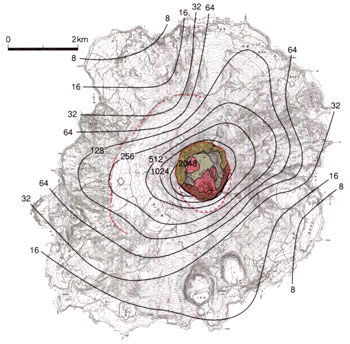
1: Introduction / 2: Topography of Miyakejima Volcano
3: History of eruptions of Miyakejima Volcano
4: Eruption of 2000 and collapse of the summit
5: Rocks of the Miyakejima Volcano
6: Possible future activities and hazard prediction / 7: Observation and monitoring
References
![]() PREV
PREV ![]() NEXT
NEXT
6: Possible future activities and hazard prediction / 7: Observation and monitoring
6: Possible future activities and hazard prediction
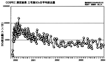
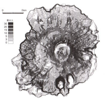
In October 2004 at the time this map was prepared, emission of white smoke and volcanic gas were on the decrease. However, amount of sulfur dioxide gas was still 3,000 to 10,000 tons per day although this was smaller than the past amounts ( ![]() Fig. 10 ). Eastern foot and SW flank areas on the leeward such as Miike, and topographic depression where gas tends to accumulate such as inside of Kuwanokitaira caldera, plants are dying or discolored and building materials are corroded. In preparation against possible lahars, erosion control dams are constructed, river courses are fixed, and various countermeasures to protect roads are under construction, but watchful eyes should be kept.
Fig. 10 ). Eastern foot and SW flank areas on the leeward such as Miike, and topographic depression where gas tends to accumulate such as inside of Kuwanokitaira caldera, plants are dying or discolored and building materials are corroded. In preparation against possible lahars, erosion control dams are constructed, river courses are fixed, and various countermeasures to protect roads are under construction, but watchful eyes should be kept.
According to experiences gained for the past 500 years, beginning of eruption is marked by remarkable volcanic earthquakes followed by fissure eruptions on the flanks within a few hours and scoria and fluid lava are extruded. It was difficult to predict where the eruption would start. Near the coast, explosive phreatomagmatic eruptions occurred. The eruption tended to finish after a few hours to a day, but if it is accompanied with summit eruption, it might prolong for several months to a few years.
However, the past may not be much relevant after the collapse of this time. There is a possible change of mode of activity. Therefore, for long-term prediction, various possibilities have to be considered besides fissure eruptions on the flank and summit eruptions. If a caldera lake is formed, phreatomagmatic eruptions and lahars from broken caldera rim are other possibilities. Very careful assessment of dangers has to be done.
7: Observation and monitoring
It is essential to monitor the volcano with highly sensitive/highly accurate instrument to evacuate in time and to prepare against hazards, as time available from precursor earthquakes to eruption is limited according to past experience. The prediction of the point of eruption is vital.
The Meteorological Agency has an observation station in Miyakejima and had 13 seismographs, 3 earthquake intensity meters, 14 GPS stations, and 4 air-shock monitors installed besides 3 telephoto-cameras within the island and others in Niijima and Mikurajima for monitoring general volcanic activities and rising smokes. National Research Institute for Earth Science and Disaster Prevention has 5 tiltmeters, and Geographical Survey Institute 8 GPS stations installed. Earthquake Research Institute of Tokyo University in cooperation with Tokyo Metropolitan Government has observation posts for earthquake, GPS, gravity, terrestrial current, and geomagnetism installed.
At the time of this article is prepared in 2004, researchers from Metrological Agency, AIST, and universities, regularly inspect the activities from helicopters in cooperation with Tokyo Metropolitan Police Department, Tokyo Fire Department, Maritime Safety Agency, and Japan Self Defense Force, and the emitted sulfur dioxide are monitored with COSPEC ( ![]() Fig. 10 ).
Fig. 10 ).