Miyakejima Volcano
1: Introduction / 2: Topography of Miyakejima Volcano
3: History of eruptions of Miyakejima Volcano
4: Eruption of 2000 and collapse of the summit
5: Rocks of the Miyakejima Volcano
6: Possible future activities and hazard prediction / 7: Observation and monitoring
References
![]() PREV
PREV ![]() NEXT
NEXT
3: History of eruptions of Miyakejima Volcano
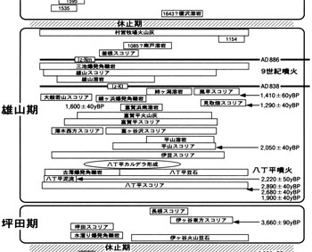
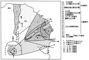
Basement rocks which existed before the birth of Miyakejima are not exposed on the surface. However, they can be seen as xenoliths in lavas as altered andesitic tuff breccia, pumice tuff, pyroxene-quartz diorite porphyry, and quartz diorite blocks and gravels. The activity of the volcano is divided into five stages based on caldera formation and dormant periods ; Pre-Ofunato stage, Ofunato stage, Tsubota stage, Oyama stage, and Shin-Mio stage. Relationship between active periods and major deposits with carbon - 14 dating is shown in ![]() Fig. 1. The dates shown are not calibrated to calendar years.
Fig. 1. The dates shown are not calibrated to calendar years.
Eleven eruptions during historical times between 1085 and 1874 were described in old documents, " Miyakejima Shoi " and " Miyakejima Goshinka Ki ( second volume )" ( Omori, 1915 ). However, those up to 1595 were just described as 'eruption' without detail. Those after 1643, on the other hand, are described in detail including forerunner phenomena, transitional events, eruptions, and post-eruption earthquakes.
3.1 Pre-Ofunato stage
Up to the formation of Kuwanokitaira caldera is Pre-Ofunato stage. The rocks belonging to this stage form west and northwest flanks and mainly consist of basaltic pyroclastic rocks and lavas. On the sea cliff northwest of Ako is exposed thick deposit of explosion breccia by phreatomagmatic activity. On the cliff backing Port Igaya is exposed an ash fall deposit belonging to well-known Aira-Tanzawa ash ( AT ). Kuwanokitaira caldera is believed to have been formed about 10,000 years ago, but the detail is not yet very clear.
3.2 Ofunato stage
The period when post Kuwanokitaira caldera volcano had grown is called Ofunato stage. Those belonging to this stage are mostly basaltic lava and pyroclastic rocks forming Miogataira lava and scoria cones. After comparatively large phreatomagmatic explosions in NW part of the island about 7,500 to 8,000 yBP ( eruption of Ofunato explosion breccia and its deposition ), activity was not vigorous until 4,000 yBP. Weathered ash deposits belonging to this period contain Kikai-Akahoya ash ( K-Ah ).
3.3 Tsubota stage
Representative ejecta of this period are lava flowed down the south flank between 4,000 and 2,500 yBP and exposed on the sea cliff from Tsubota to Tatsune, and lava and accretionary lapilli of Igaya accretionary lapilli deposit ( about 0.1 km3 in lava equivalent. Hereafter all the volumes are to be shown as lava equivalent. ), which erupted at the northwest foot of the volcano about 4,000 yBP. These are andesitic in nature and can be clearly discriminated from preceding and following activities.
3.4 Oyama stage
Within the Hatchodaira caldera, Oyama, the post-caldera volcano, was born about 2,500 yBP. The eruption, Hatchodaira eruption, which created Oyama, was the largest ( about 0.4 km3 ) for the last 10,000 years.
Hatchodaira eruption It started as a scoria eruption from the center of the volcano, then changed to phreatomagmatic eruption ejecting fine-grained scoria. The scoria deposited throughout the island with thicknesses from several tens of cm to 5 m (Hatchodaira scoria). It was followed by mud flow in the eastern flank (Hatchodaira mud flow). Then a fissure opened up to the south resulting in phreatomagmatic eruptions and created Furumio maar ( Tairoike ), Explosion also occurred on Yamamio maar and on the sea floor offshore to the south and ejecting copious explosion breccia. Fine-grained ash from the central part of the volcano covered the whole island as accretionary lapilli ( Hatchodaira accretionary lapilli ). Those occurred within a geologically short time.
After the formation of Hatchodaira caldera and during Oyama stage, at least 15 cycles of eruptions can be recognized. As the ejected materials consist mainly of fine-grained ash fall, and quenched, comminuted, and poorly vesiculated scoria fall, the environment must have been favorable to produce phreatomagmatic eruptions - probably water was readily available in the caldera.
Eruption during 9th century An eruption within the Hatchodaira caldera, which occurred in the middle of 9th century, produced about 0.08 km3 lava.
Part of the lava overflowed the rim of the caldera and flowed down to reach Furumio and Mizutamari in the south and the coast beyond Kanaso to the east. This was followed by scoria eruption from the center of the caldera, and a fissure opened up in the eastern flank to Miike causing phreatomagmatic explosion. Miikehama is a remain of the crater created at this time. Near here thickness of explosion breccia is over 10 m, and ash from this eruption deposited all over the island.
Eruption during 11th century Eruption of 1085 ( 2nd year of Otoku ) seems to have occurred within Kuwanokitaira caldera at its SE part. Nanto lava flow ( NTL ) exposed along a forest road east of Ako is believed to have derived from this eruption.
Eruption during 12th century November 1154 eruption ( October, first year of Kyuju ) seems to have occurred along a fissure extending from Hinoyama Pass to Shiitori Shrine. Volcanic bombs and scoria fall deposits of this eruption are overlain by black Son-ei Bokujo ash ( SBA ) which is distributed all over the island. This eruption was followed by a dormant period of about 300 years.
3.5 Shin-Mio stage
In 1469 the activity resumed. Since then 12 eruptions are recorded before 1983. The eruptions of Shin-Mio stage were mostly from flanks as fissure eruptions. In 1940, and probably in 1535, 1763, and 1811, there were summit eruptions as well. There is a gap in chemistry of ejecta of this stage, which was basaltic, and those in the latest Oyama stage, which was less basaltic.
Eruption during 15th century On December 24th 1469 (3rd year of Onin, but due to change of calendar, the same date is also expressed as November 12th of 1st year of Bunmei) , a fissure of western Kuwanokitaira caldera floor erupted, and Enokizawa lava flow ( EZL ) flowed down along Enokizawa valley overflowing caldera wall at its lowest part.
Eruptions during 16th century In 16th century, two eruptions are known in March 1535 ( February of 4th year of Tenmon ) and November 22nd 1595 ( October 21st of 4th year of Bunroku ). In both of these, aligned scoria cones were formed along fissures on SE flank of the mountain, and Cape Benkenemisaki lava flow ( BKL ) in 1535 and Kamakata lava flow ( KKL ) in 1595 were erupted.
Eruptions during 17th century Detailed description of 1643 eruptions are available in old documents. On March 31st ( February 12th of 20th year of Kan-ei ) an earthquake was felt during heavy rain and at 20:00 eruption started on the flank. Lava flow came down to Ako burying and burning all the houses and extended about 1 km further into the sea. Other lava flows came down to Sabigahama and Yuke. Tsubota at SE foot received scoria fall and agricultural crops were damaged. People from Ako and Tsubota escaped harm by evacuating to Toga Shrine and Kamitsuki. Those people who lost their houses and farms had to move to Higashiyama ( close to current Kadoyashiki ). Tremors and eruptions stopped after about 3 weeks.
SSE fissure eruptions of 18th century In SSE part of Miyakejima, three fissures which erupted in 18th century can be recognized.
On February 4th 1712 ( December 28th of first year of Shotoku ) frequent earthquakes, thundering and lightning were observed after 18:00. An eruption started at Kuwanokitaira was visible from the foot at 20:00. The erupting area spread sideways and fire column was seen near Tatsunenohama. After about 1 hour the activity of eruption became weak but lava flow spread from Tatsunenohama to 200 m offshore and to 300 to 400 m to NW direction. Returned people from Ako and Tsubota after a week of living as refugees found their houses in Ako completely submerged in muddy water and all their cows and horses dead.
After 2 weeks the activity became quiet. Judging from the descriptions, easternmost fissure among three fissures seems to correspond to this eruption.
Frequent tremors and sounds occurred on the night of August 17th 1763 ( July 9th of 13th year of Horeki ) and red hot rock fragments flew like lightning near the summit of Oyama. Eruption also started at Usugi accompanied with tremors and sounds. A deep crater was formed in Usugi and it was filled by seeped water. It is said that this crater is Shin-Mioike. The activity continued till 1769 ( 6th year of Meiwa ). Central fissure of three aligned fissures was responsible to this eruption. Thick scoria deposits covered SE foot area. Covering this scoria, explosion breccia deposited in Usugi. From small crater north of Shin-Mioike a lava flow came down to Usugi. People of Ako had to shift to current residence from Higashiyama again.
From the westernmost fissure of three fissures, lava flows came down to Kamane maar ( Inasabura ) and Usugi. This fissure eruption seems to correspond to the eruption of 1763 to late 1769 or an unrecorded eruption after 1769. Chemical composition of the ejecta is different from that of 1763.
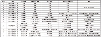
Eruptions during 19th century Three eruptions are known during 19th century; 1811, 1835, and 1874.
On January 27th 1811 ( January 3rd of 8th year of Bunka ) there were earthquakes at night. Column of fire was seen at the summit. The fire moved to ENE direction and became quiet by early morning. Lively earthquake activity continued for 6 days until February 1st. Cracks were opened up on the ground of Izu area according to a report.
On November 10th 1835 ( September 20th, 6th year of Tempo ) earthquake was felt from before lunch time and became stronger with time. Smoke rose from western flank and red hot magma was visible. Thirteen craters opened up and lava flowed down to Kasaji Kannon. There was ash fall at Nakayama Kannon halfway between Igaya and Ako. The eruption stopped by midnight but smoking and seismic activity continued. There was a collapse at the night of 13th caused by strong tremor. The earthquake activity ended by 19th.
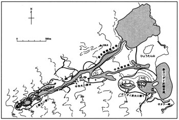
On July 3rd 1874 ( 7th year of Meiji ) at about noon, suddenly intense earthquakes and sounds were felt, and on NNE flank at about 560 m a.s.l., a fissure opened up. Line of craters down to about 200 m was created. Smoke spread east of craters blown by southwester lies to reach Tosa to Hodai areas and a quantity of coarse-grained ash fell. After scoria fall, lava started to flow out. By that evening lava reached sea via Higashigo, which existed east of where Kamitsuki currently stands ( ![]() Fig. 2). Eruptions and tremors continued for 4 more days and other activity about 2 more weeks. With this eruption, 30 strong houses of Higashigo were buried under the volcanic debris and a person went missing.
Fig. 2). Eruptions and tremors continued for 4 more days and other activity about 2 more weeks. With this eruption, 30 strong houses of Higashigo were buried under the volcanic debris and a person went missing.
Eruptions during 20th century During 20th century eruptions occurred at about 20 year intervals; 1940 ( 25th year of Showa ), 1962 ( 37th year of Showa ), 1983 ( 58th year of Showa ), and 2000 ( 12th year of Heisei ). For those, scientific observations were carried out.
Before the eruption of July 1940, rising steam was observed near Akabakkyo for over half a year. For about a week before the eruption, ground temperature rose and fumarolic activity increased with earth sounds. The eruption started at about 200m a.s.l., NE flank of Oyama, on July 12th 19:30. The fissure extended to higher as well as lower flanks, and columns of flame were visible on a line between the summit and Akabakkyo Bay below 500 m a.s.l. At the same time, lava came down along the valley between old Kamitsuki and old Tsubota reaching Akabakkyo Bay in an hour ( ![]() Fig. 2 ). The eruption continued without break until 18:00 of 13th, the next day. After that it suddenly weakened. Outflow of lava and ejections of bombs, scoria, and ash accompanied with formation of Hyotanyama scoria cone occurred within 22 hours from about 20:00 of 12th.
Fig. 2 ). The eruption continued without break until 18:00 of 13th, the next day. After that it suddenly weakened. Outflow of lava and ejections of bombs, scoria, and ash accompanied with formation of Hyotanyama scoria cone occurred within 22 hours from about 20:00 of 12th.
From midnight of July 13th the summit crater started to erupt. Eruption at the flank stopped at 3:30 as the last explosion, but from the summit it continued until about 18th with much smoke and ash fall in NE direction. From 19th to 20th the crater enlarged and the sound of explosion was clearly heard at the foot with scoria fall in addition to ash on 21st and 22nd. From 24th to 26th the activity of the summit crater culminated with sound of explosions without interruption and volcanic bombs were thrown out quite often. By this time the summit crater was filled by lava and some might even have overflowed. Lively activities continued until 30th, but became weak after 31st. The sound of explosions became inaudible. At night on August 3rd and 4th volcanic glow was visible from Izu. From August 3rd to 6th ash fall occurred in Igaya and Izu, and smell of hydrogen sulfide was felt. By August 8th the activity of the summit crater almost ceased.
Because this activity started from the flank close to residential areas, 11 people were dead and 20 injured. Totally destroyed and burnt houses amounted to 24 and casualty of cows was large.
About 2 hours before the start of the eruption, at 20:29 on August 24th 1962, volcanic tremor was recorded at Miyakejima Meteorological Station and the tremor became more frequent with time. A few minutes before 22:20 eruption started at the boundary of old Kamitsuki and old Tsubota in the ENE flank of the volcano. According to a sketch seen from northern foot ( Meteorological Agency, 1964 ), the eruption commenced from upper group of craters about 400 to 500 m a.s.l., and the fissure extended gradually further up as well as to middle group of craters, then to lower group of craters ( Yoridaizawa Valley ). At 23:11 power line was cut between Akabakkyo and Yoridaizawa and continuous columns of flames were developed from the flank to the coast. At 23:39 the top of the erupting line further extended higher up. Gradually center of eruption shifted to lower flank. On the next day, 25th, at about 1:00 upper craters ceased to erupt, and by the morning of the same day middle group of craters also stopped to erupt. Lower craters continued activity ejecting cinders until midnight, but became quiet by 3:00 to 5:00 next morning, 26th. Total of craters was counted to be about 20 spreading for 1.8 km. Bombs and blocks were deposited within 200 m of the craters while ash deposited on NE flank ( ![]() Fig. 3 ). Cinders ejected from lower group of craters formed Sanshichiyama scoria cone. Three lava flows were recognized; Shi- Akabakkyo lava came down to Akabakkyo, Central lava to the south of Hyotan-yama, and Yoridaizawa lava to the south of Sanshichiyama. Total volume of ejecta is estimated to be about 20,000,000 tons.
Fig. 3 ). Cinders ejected from lower group of craters formed Sanshichiyama scoria cone. Three lava flows were recognized; Shi- Akabakkyo lava came down to Akabakkyo, Central lava to the south of Hyotan-yama, and Yoridaizawa lava to the south of Sanshichiyama. Total volume of ejecta is estimated to be about 20,000,000 tons.
After the end of surface activities, strong earthquakes hit the island. On August 26th at 15:48 an earthquake of MJMA ( magnitude scale of Japan Meteorological Agency ) 5.9 ( seismic intensity at Miyakejima 5 ) occurred with its focus to the west of Miyakejima at depth 40 km. In NW island where the eruption did not occur was hit by many felt earthquakes. On August 30th at Izu, number of felt earthquakes was over 2,000 times. Some of the residents fled for refuge outside of the island.
On October 3rd 1983, at about 13:59, from about 1 hour and 15 minutes before the commencement of eruption, seismograph of Miyakejima Meteorological Agency started to record harbinger small earthquakes, and at 14:46 the information was passed from the Meteorological Agency to the Municipal authority. Almost immediately after the disaster prevention measures were readied, at about 15:15 near Jinansan, 450 m a.s.l., SW flank of Oyama, erupted. Erupting fissure was extended upward and downward of the flank of the volcano. For about top 3 km of the fissure the eruption was lava fountaining and after 20:00 changed to Strombolian from small number of craters. Most of the erupted magma flowed down along valleys. The largest of lava flows crossed major road at about 17:20 and came down to Ako. It was only 10 minutes after the last evacuee-carrying bus from Ako passed. Eighty people left behind in Ako were evacuated by fishing boats. The lava buried and burnt 340 houses. On the other hand, as the fissure crater near Shin-Mioike and Nippana beach opened up below 100 m a.s.l. and on the sea floor, violent phreatomagmatic eruptions ensued at 16:38, 17:10, 19:17, 22:36, and subsequent hours. Most ejecta as pyroclastic materials deposited in Tsubota area covering houses, farmlands, and forest and damaged those. Just after an earthquake of MJMA 6.2 ( intensity at Miyakejima Meteorological Agency office 5 ) at 22:33 with its focus at 4.6 km south of Nippana and 15 km deep, eruptions at the southern sea shore temporarily became more active, but after 23:00 it became intermittent and ended by 6:00 next day, 4th. Earthquake activity became weak by the morning of 6th. The sequence of events of this whole activity was quite different from those in 1962. Length of fissure was 4.5 km and number of craters was over 90.