Fuji Volcano
1: Introduction - 2: Overview of Geological Features - 3: Previous studies
4: Geological descriptions
5: Petrological characteristics of the eruption products - 6: Conclusions
Acknowledgements / References
![]() PREV
PREV ![]() NEXT
NEXT
1: Introduction - 2: Overview of Geological Features - 3: Previous studies
1: Introduction
Fuji Volcano is the largest polygenetic volcano in Japan. In contrast to the Nara (710 to 794 AD) and Heian periods (794 to 1185 AD), when it was fairly active, Fuji Volcano has remained dormant for the last 3 centuries since last erupting in 1707 AD during the Hoei era. If an eruption on the scale of the Hoei eruption were to occur today, volcanic ash would fall not only in the vicinity of Fuji Volcano but possibly as far away as Tokyo. An eruption of the type that occurred during the Hoei era is only one of many possibilities. Given the volcano’s eruptive history since the initiation of volcanic activity 100,000 years ago, a completely different type of eruption may indeed occur. In order to understand and prepare for the range of possible eruptions types, we must obtain quantitative data regarding the ages, location, magma type, volume, and styles of past eruptions for Fuji Volcano. In the half century that has passed since publication of the geological map of Fuji Volcano (Tsuya, 1968), much research has been conducted on Fuji Volcano, accompanied by numerous advances in dating methods and the development of a wide range research methods other than traditional walk-over surveys. This map of Fuji Volcano (2nd edition) is based primarily on traditional walk-over surveys but includes data from boring and trenching surveys. It summarizes quantitative data on the stratigraphic succession of volcanic products and provides detailed information regarding locations of flank eruptions and lava flow (LF) distributions using current methods of radiocarbon dating, aerial survey data, and various analytical methods. The map provides fundamental information regarding eruptive history of Fuji Volcano and should prove useful to research on eruption prediction and disaster mitigation efforts.
2: Overview of Geological Features
2.1 Tectonic setting
Fuji Volcano is an island arc volcano located in a geologically complex region at the intersection of three plates. The Japanese archipelago straddles the North American and Eurasian Plates; Fuji Volcano has developed near the root of the Izu Peninsula where the Philippine Sea Plate from the south collides with and splits to the east and the west as it is subducted beneath these two continental plates. The magma under Fuji Volcano is generated by subduction of the Pacific Plate and wells up through a split in the Philippine Sea Plate as it sinks while causing intermittent earthquakes. Low-frequency earthquakes contributing to fluid flow are known to occur below Fuji Volcano around a depth of 15 km (Ukawa, 2007). A stable magma reservoir that continually supplies basaltic magma to the volcano is believed to lie directly under this zone at an approximate depth of 20 km (Ukawa, 2007; Fujii, 2007). This unique setting is the reason why Fuji Volcano is the largest basaltic polygenetic volcano in Japan and explains the volcanic high variability in terms of eruption interval, eruption volume, eruption location, and eruption type (Takada, 2015).
2.2 Geology of the surrounding area
Basement rocks (B)
The western foot of Fuji Volcano primarily comprises the Fujikawa Group consisting of Miocene sedimentary rock and andesite intruded by lower and middle Pleistocene Bessho Gravel Bed. The northwestern, northern, and northeastern flanks primarily comprise the Nishiyatsushiro Group and Tanzawa Group consisting of Miocene sedimentary rock and basalt (Ozaki et al., 2002; Matsuda, 2007; Sugiyama et al., 2010). The above Miocene strata are intruded by Sanogawa granodiorite in the west, Ashikawa granodiorite in the north, and the Tanzawa granodiorite in the east.
Products of the Iwabuchi Volcano (Iwb)
Products of the Iwabuchi Volcano that was active during the early to middle Pleistocene are distributed on the southeastern foot of Fuji Volcano (Sugiyama et al., 2010). These products mainly comprise various types of basaltic to andesitic lavas and volcaniclastic rocks.
Products of the Hakone Volcano (Hkn)
Products of the Hakone Volcano that has been active since the middle Pleistocene are distributed on the southeastern foot of Fuji Volcano (Sugiyama et al., 2010). These products primarily comprise various types of basaltic to andesitic lavas and dacitic to rhyolitic pyroclastic flow deposits.
Products of the Ashitaka Volcano (Ast)
Products of the Ashitaka Volcano that was active during the middle and late Pleistocene are distributed on the southern foot of Fuji Volcano (Sugiyama et al., 2010). These products primarily comprise various types of basaltic to andesitic lavas and andesitic pyroclastic flow deposits. Volcanic fan deposits are distributed at the foot of the volcano.
Products of the Pre-Komitake Volcano (PK)
A single layer of aphyric basaltic andesite lava unconformably underlying the lowest lava from the Komitake Volcano is exposed in the lower reaches of the Yoshida-Osawa valley (Ohorizawa) on the eastern flank of Fuji Volcano. Based on the chemical compositions, this layer are correlated with products from the pre-Komitake Volcano (270 to 160 ka: K-Ar dating) described by Nakata et al. (2007) and Yoshimoto et al. (2010)
Products of the Komitake Volcano (K)
Products from the Komitake polygenetic volcano, which are intercalated with multiple layers of aa lava that are 2 m or less in thickness and are inconsistent with the overlying products of the Fuji Volcano, are exposed in the Ohorizawa (gorge), to the north and east of the Komitake Shrine located at the end of the Fuji Subaru Line at the 5th station on the north slope of Fuji Volcano (Tsuya, 1938a). These products are also exposed in the vicinity of the Izumitaki (water fall). The rocks are basalt or basaltic andesite with 30% to 45% phenocryst content consisting of plagioclase (3 mm or less) and mafic phenocrysts, and are readily distinguishable from products of Fuji Volcano. The rocks have markedly lower K2O and TiO2 content than those of Fuji Volcano. Furthermore, clear differences are observed between the basaltic andesite found in the Ohorizawa and the basalt and basaltic andesite found to the north of the Komitake Shrine. Two ages based on K-Ar dating, 76 ± 13 ka and 109 ± 16 ka, have been reported for the rocks lying to the north of the Komitake Shrine (Nakano et al., 2009; Yoshimoto et al., 2009).
2.3 Characteristics and eruptive history of Fuji Volcano
2.3.1 Characteristics of Fuji Volcano
Fuji Volcano is particularly large among land volcanoes on the Japanese archipelago. In contrast to the majority of volcanoes in other parts of Japan that have a volume of 100 km3 or less, Fuji Volcano is estimated to have a volume between 400 to 500 km3 (Takada et al., 2007, 2013). Another characteristic of the volcano is the fact that it has continued to erupt basaltic lavas for an extremely long time.
Fuji Volcano is known to exhibit many different types of eruptions. One type of eruption involves the effusion of large amounts of lava over an extend period of time. For example, effusive eruptions in which more than 1 km3 of lava was erupted occurred several times at around 10 ka. In more recent times, a total of approximately 1.5 km3 of the Aokigahara Lava Flow was effused during the Jogan eruption that lasted two years starting in 864 AD (Chiba et al., 2007; Takahashi et al., 2007). In contrast, the Hoei eruption of 1707 AD was an explosive eruption in which approximately 0.7 km3 of pyroclastic materials was ejected but this eruption lasted only two weeks (Miyaji et al., 2011).
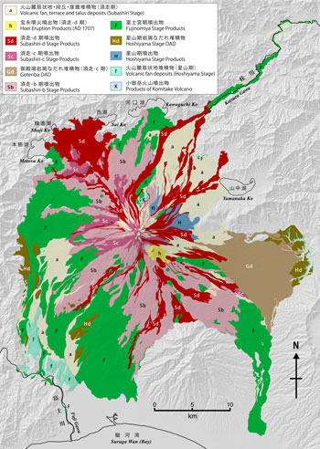
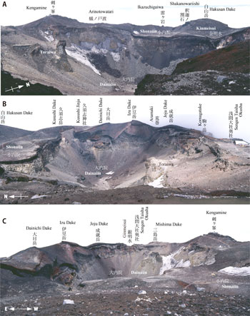
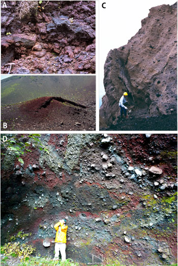
The occurrence of numerous fissure eruptions not only at the volcano summit but also on its flanks (![]() Frontispiece 2-B) and the existence of different periods in which either summit or lateral fissure eruptions are predominant (Miyaji, 1988; Takada, 1997) are further examples of the diversity of eruption types exhibited by Fuji Volcano. Although the predominant direction of fissure eruptions, statistically speaking, is northwest-southeast, i.e. the same as the direction in which the Philippine Sea Plate is pushing, fissure eruptions erupting lavas to the northeast and southwest have also occurred. From the distribution of fissure eruptions, it appears that they typically occur within 13 or so km of the summit (Takada et al., 2007).
Unlike shield volcanoes such as those in Hawaii, polygenetic volcanos with extremely wide bases such as Fuji Volcano are not formed exclusively by lava flow eruptions. Explosive summit eruptions create cone-shaped mountains with steep sides accompanied by volcanic fans that form broad bases. The edifice of Fuji Volcano has collapsed on numerous occasions in the past at a greater frequency than that of any other volcano in Japan (Yamamoto et al., 2002).
Frontispiece 2-B) and the existence of different periods in which either summit or lateral fissure eruptions are predominant (Miyaji, 1988; Takada, 1997) are further examples of the diversity of eruption types exhibited by Fuji Volcano. Although the predominant direction of fissure eruptions, statistically speaking, is northwest-southeast, i.e. the same as the direction in which the Philippine Sea Plate is pushing, fissure eruptions erupting lavas to the northeast and southwest have also occurred. From the distribution of fissure eruptions, it appears that they typically occur within 13 or so km of the summit (Takada et al., 2007).
Unlike shield volcanoes such as those in Hawaii, polygenetic volcanos with extremely wide bases such as Fuji Volcano are not formed exclusively by lava flow eruptions. Explosive summit eruptions create cone-shaped mountains with steep sides accompanied by volcanic fans that form broad bases. The edifice of Fuji Volcano has collapsed on numerous occasions in the past at a greater frequency than that of any other volcano in Japan (Yamamoto et al., 2002).
2.3.2 Eruption stages of Fuji Volcano
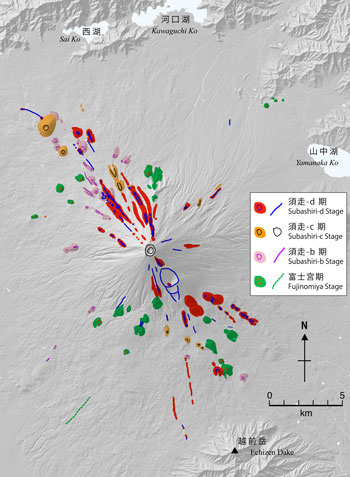
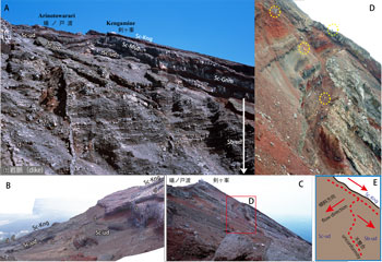
The most important aspect of the stratigraphic classification proposed by Tsuya (1940, 1968) is the division of volcanic activity into “older” and “younger” stages of Fuji Volcano, which we refer to in this document using the Japanese nomenclature "Ko-Fuji" and "Shin-Fuji", respectively. Tsuya (1940, 1968) justified this division based on (1) clear differences in the structural geology of products from the two stages, with volcanic materials from Ko-Fuji Volcano (but not from Shin-Fuji Volcano) having been clearly displaced by activity of the Fujikawa-kako Fault Zone ; (2) a clear stratigraphic relationship in which weathered volcanic materials from Ko-Fuji Volcano is overlain by volcanic materials from Shin-Fuji Volcano; and (3) a clear difference in type of volcanic activity indicated by the predominantly pyroclastic materials from Ko-Fuji Volcano on the foot and lava flows from Shin-Fuji Volcano. Tsuya (1940, 1968) further hypothesized that there was a dormant period separating the two stages of the volcano. In contrast, Machida (1977) divided the activity of Fuji Volcano into “old period” and “new period” eruptions demarcated by the Fuji Black Soil based on the stratigraphy of tephras at the foot of the volcano. The stages as defined by Tsuya and Machida represent two alternative categorizations of the volcanic history and indicate the need to reconstruct the eruptive history of Fuji Volcano based on, among other things, a comparison of materials of the volcanic edifice and tephras at the foot of the volcano. In this study, we comprehensively investigated the relative stratigraphy and radiocarbon ages of materials of the volcanic edifice including lava flows, pyroclastic cone deposits, debris avalanche deposits, and pyroclastic flow deposits, with tephras at the foot of volcano. Based on this analysis, we adopted the developmental categorization proposed by Yamamoto et al. (2007) that divides volcanic activity into the Hoshiyama (approximately 100 ka to 15,000 cal BC) and Fujinomiya (15,000 to 6,000 cal BC) Stages, respectively occurring before and after the period of massive lava effusion at around 17 ka, and the Subashiri Stage following the Fuji Black Soil designated by Machida (1977). The name “Subashiri” comes from Izumi et al. (1977) and Uesugi et al. (1979, 1987). The Subashiri Stage is further divided into the Subashiri-a (6,000 to 3,600 cal BC), Subashiri-b (3,600 to 1,500 cal BC), Subashiri-c (1,500 to 300 cal BC), and Subashiri-d (300 cal BC to present) (![]() Frontispiece 1).
Frontispiece 1).
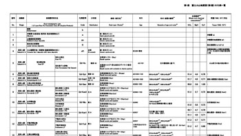
Of the stratigraphic units defined by Tsuya (1968, 1971), some could not be located or do not currently exist and thus do not appear on the geologic map. The superscripts following the stratigraphic unit names below correspond to the unit numbers in ![]() Appendix 1.
Appendix 1.
2.3.3 Representative eruptions of historical age
The Aosawa LF37 that occurred in the 6th century flowed down the southern flank of the volcano. A sanctuary-less Shinto shrine, serving as the origin of the Fuji Hongu Sengen Shrine, was established at the lower end of this LF. The main shrine of the Sengen Shrine was subsequently relocated to its current location (near Wakutamaike in Fujinomiya City) during the Heian era.
Fuji Volcano was fairly active during the Nara and Heian periods. Fissure eruptions were especially common on the northwestern, southeastern, and eastern flanks of the volcano. Between 700 to 900 AD, fissure eruptions occurred frequently from the northwest to southeast. Distributed on the northwestern flank are volcanic products from successive eruptions including the Yakeno EP26, the Oniwa-Okuniwa 1 EP25, the Oniwa-Okuniwa 2 EP24, the Hakudairyuo-Koriike EP23, and the Tenjin-yama-Igatonoyama EP19 as well as products from the Jogan eruption that yielded the Aokigahara LF17 (864 to 866 AD) for which historical records exist. Volcanic products from the Kansu EP22, which occurred around the same period, are found on the southeastern flank of the volcano.
Approximately between 900 and 1000 AD, the dominant orientation of fissure eruptions shifted from northwest-southeast to north-south, as evidenced by the Higashiusuzuka-minami EP16 and the Obuchimarubi EP13 (Yamamoto et al. 2005; Takada et al. 2007). In addition, there were two eruption events, once each, from 12 km and 8 km long north-south fissures straddling the summit. These correspond to the Kenmarubi 1 EP11 and the Kenmarubi 2 EP9 found on the northern flank as well as the Fudosawa EP12 and the Nissawa EP10 on the southern flank, respectively.
At present, the youngest lava flow according to radiocarbon dating is the Suyamatainai LF6 identified in a trench survey conducted in 2002 (Kobayashi and Takada, 2003). The 2σ confidence interval for the age of charcoal collected from the base of the lava flow is between 1030 and 1220 cal AD (1 in ![]() Appendix 2; Yamamoto et al., 2005).
Appendix 2; Yamamoto et al., 2005).
Meanwhile, the eastern to northeastern slopes of the volcano experienced vigorous volcanic activity over an extended period of time in the form of fissure eruptions (Yamamoto et al., 2011). For example, the Takamarubi LF20 on the northeastern flank from the Enryaku eruption, which occurred in 800 AD and is described in "Nihon Kiryaku", extends to the vicinity of the present-day Oshino Village and Lake Yamanaka (Yamanaka-ko).
Volcanic activity began to decline in the Kamakura period and later. Although historical documents contain records of a number of small eruptions and volcanic smoke, even if the reports are accurate, the activity was clearly not of a magnitude sufficient to leave deposits.
2.3.4 The Hoei eruption
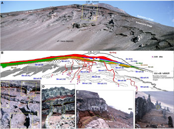
Among the various eruptions of Fuji Volcano, the Hoei eruption of AD 1707 (year 4 of the Hoei era) is the only eruption for which a detailed historical record exists. The Hoei eruption was an explosive eruption that occurred on the southeastern flank of the volcano and resulted in the creation of three craters (![]() Frontispiece 8-C). In the earliest stages of the eruption, the volcano released a small amount of felsic magma, which is rare for Fuji Volcano, followed by basaltic magma. It should also be noted that the 8.4 magnitude Hoei earthquake occurred at the boundary of the Philippine Sea Plate on October 28, 1707, just 49 days before the Hoei eruption. The area surrounding Fuji Volcano experienced frequent aftershocks following the earthquake, which increased in frequency on December 15. A major aftershock occurred on the morning of December 16, preceding the eruption, which began in the afternoon of the same day. The eruption continued for approximately two weeks, cycling between periods of high and low activity before ending altogether in the early morning of January 1 of the following year (Miyaji and Koyama, 2007).
Frontispiece 8-C). In the earliest stages of the eruption, the volcano released a small amount of felsic magma, which is rare for Fuji Volcano, followed by basaltic magma. It should also be noted that the 8.4 magnitude Hoei earthquake occurred at the boundary of the Philippine Sea Plate on October 28, 1707, just 49 days before the Hoei eruption. The area surrounding Fuji Volcano experienced frequent aftershocks following the earthquake, which increased in frequency on December 15. A major aftershock occurred on the morning of December 16, preceding the eruption, which began in the afternoon of the same day. The eruption continued for approximately two weeks, cycling between periods of high and low activity before ending altogether in the early morning of January 1 of the following year (Miyaji and Koyama, 2007).
The Hoei eruption caused widespread damage with long-lasting effects. More than 1 m of volcanic lapilli was deposited in Subashiri, Oyama Town, resulting in the destruction of numerous houses and buildings by fire or collapse. Agricultural land that accumulated more than 1 m of lapilli was subsequently restored to an arable state through deep-plowing efforts by local residents known as tenchi gaeshi (literally, “flipping heaven and earth”). In the Tanzawa mountains, subsequent rainfalls caused avalanches of lapilli and volcanic ash accumulated on the steep mountains slopes to flow into the Sakawagawa River (lower reaches of the Ayuzawagawa River), raising the height of the riverbed. As a result, the Sakawagawa River experienced flooding during heavy rains for a period of approximately 100 years. Further from Fuji Volcano, volcanic ash was deposited to a depth of 30 cm in Atsugi (Kanagawa Prefecture), 20 cm in Yokohama, and several cm in Tokyo, causing blockages of irrigation ditches and drainage channels in Yokohama and areas to the west.
3: Previous studies
Geological research on Fuji Volcano began in the Meiji period (Wada, 1882; Suzuki, 1886a, b), and included the publication of a 1:200,000 geological map “Fuji” by Suzuki (1887). Meanwhile, Edmund Naumann published a general overview of Mt. Fuji from a geologic standpoint (1888, translated into Japanese by Yamada and Yajima, 2013). Subsequently, Ishihara (1925) published a 1:50,000 geologic map of Fuji Volcano, and Sawamura (1955) published a 1:75,000 map of the Numazu area including Fuji Volcano.
Volcanological research of Fuji Volcano includes numerous studies by Tsuya focused on the distribution of lava flows (e.g. Tsuya 1937, 1938a, 1938b, 1940, 1944, 1955, and 1962). The culmination of this research was a 1:50,000 Geological Map of Fuji Volcano, published by Geological Survey of Japan (Tsuya, 1968). Machida (1964, 1977) clarified the entire eruptive history of Fuji Volcano for the first time using the stratigraphic sequence of volcanic ash. This was followed by the publication of a geological guide book providing detailed descriptions of the stratigraphic sequences of volcanic ash, particularly of the eastern foot of the volcano (Uesugi, 2003). Miyaji (1988, 2007) studied the eruptive history of Fuji Volcano, including the relative active periods of the various flank eruption craters near the current volcano, using the stratigraphic sequence of volcanic ash. The results of detailed field surveys conducted in the different zones of Fuji Volcano have been made available to the public (e.g. Ogawa, 1986). Due to the volcano’s location at the boundaries of different tectonic plates, research on active faults in the vicinity of the volcano (e.g. Yamazaki, 1992) have also proved useful for reconstructing the stratigraphy of Fuji Volcano.
Ground surface surveys that rely on the investigation of outcrops are of limited use. In recent years, efforts to quantitatively reconstruct Fuji volcano’s eruptive history have been carried out based on coring studies (Miyaji et al., 1995, 1998, 2001; Nakata et al., 2007; Yamamoto et al. 2007; Yoshimoto et al., 2010) and trench surveys (Takada et al., 2007; Ishizuka et al., 2007; Nakano et al., 2007; Suzuki et al., 2007; Kobayashi et al., 2007) combined with ultrasensitive radiocarbon dating (Yamamoto et al., 2005). In addition, aerial LiDAR technology has been successfully used to create red relief image maps (Chiba et al., 2007), perform land classification based on lava flows, and identify the distribution of flank eruption craters. In the case of eruptions for which historical records exists, efforts are being made to analyze such records (Tsuji, 1992) and to compare the descriptions contained therein to evidence from volcanic products (Koyama, 1998a, 2007).
![]() PREV
PREV ![]() NEXT
NEXT