Fuji Volcano
1: Introduction - 2: Overview of Geological Features - 3: Previous studies
4: Geological descriptions
5: Petrological characteristics of the eruption products - 6: Conclusions
Acknowledgements / References
![]() PREV
PREV ![]() NEXT
NEXT
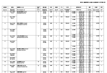
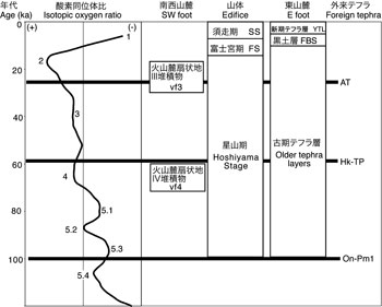
Fig.1 Stratigraphy of the products of Fuji Volcano.
ka: 1,000 years. Numerals are the numbers of the Marine Oxygen Isotope Stage.
The tephrostratigraphy in the eastern foot are based on Machida (1964).
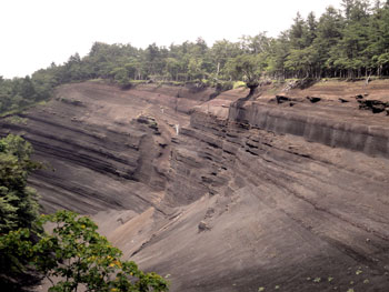
Fig.2 Massive layers of scoria fall deposits exposed in the eastern foot of Fuji Volcano.
Photo taken at Subashiri, Oyama Town, Shizuoka Prefecture.
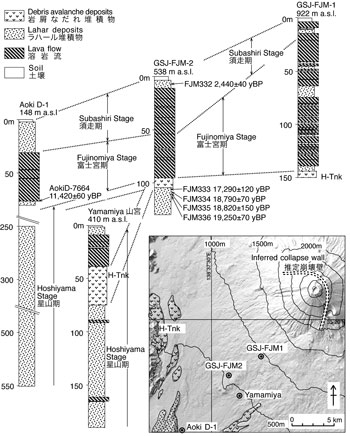
Fig.3 Columnar sections and index map of the borehole cores in the southeastern foot.
H-Tnk; Tanukiko Debris Avalanche Deposit. After Yamamoto et al. (2005).
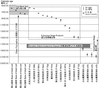
Fig.4 Calendar ages for the volcanic fan III deposits, the products in the Fujinomiya Stage and the Fuji Black Soil.
F-Aoki SP-4 Lava Flow (F-SP4) is concealed in 58-76 m depth at the Aoki D-1 core (Fig. 3). Modified from Yamamoto (2014).
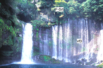
Fig.5 Shiraito Lava Flow (F-Srt) in the Fujinomiya Stage unconformably overlying the volcanic fan III deposits (vf 3).
Photo taken at the Shiraitonotaki Fall,Fujinomiya City, Shizuoka Prefecture.
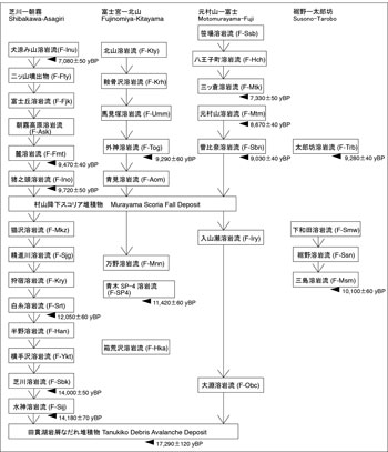
Fig.6 Stratigraphic relationship of the Fujinomiya Stage lava flows in the southern half of the volcano.
F-SP4 Lava Flow is concealed in 58-76 m depth at the Aoki D-1 core (Fig. 3). Modified from Yamamoto et al. (2007).
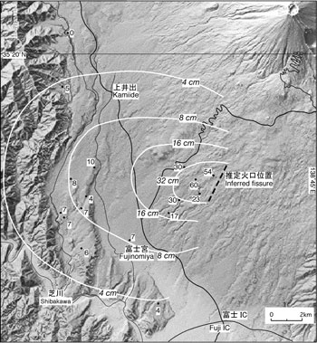
Fig.7 Distribution of the Murayama Scoria Fall Deposit and inferred eruption fissure.
Numerals are measured thickness of the fall deposit in centimeters. Modified from Yamamoto (2014).
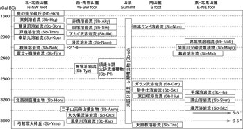
Fig.8 Stratigraphy of the representative products in the Subashiri-b Stage.
Gray arrows mean pyroclastic fall deposits. * is not shown in the geological map. Age-unknown products are not included.
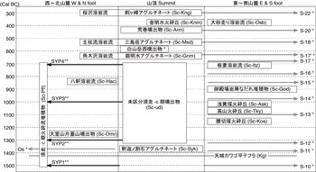
Fig.9 Stratigraphy of the representative products in the Subashiri-c Stage.
Gray and black arrows mean pyroclastic fall and pyroclastic flow deposits, respectively. Age-unknown products are not included.
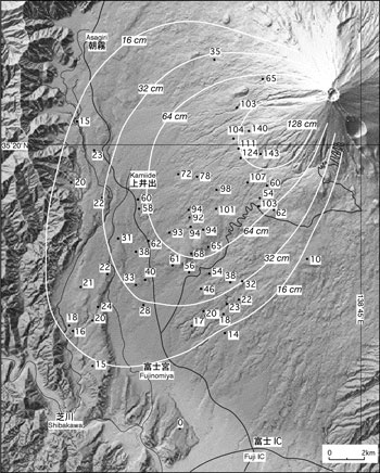
Fig.10 Distribution of the Osawa Scoria Fall Deposit.
Numerals are measured thickness of the fall deposit in centimeters. Modified from Yamamoto (2014).
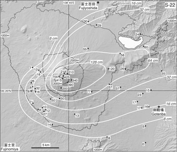
Fig.11 Distribution of the S-22 Scoria Fall Deposit.
Numerals are measured thickness of the fall deposit in centimeters.
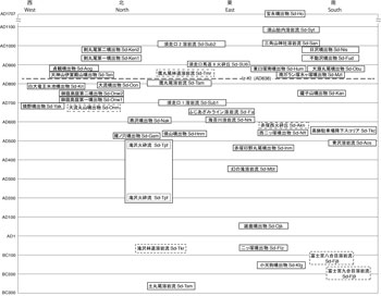
Fig.12 Stratigraphy of the products in the Subashiri-d Stage.
Units with broken frame indicate uncertain ages.
Fig.13 Distribution of the pyroclastic fall deposits ejected on the Hoei eruption.
Numerals are measured thickness of the fall deposit in centimeters. Modified from Miyaji and Koyama (2007).
4: Geological descriptions
Here we provide geological descriptions of products of Fuji Volcano based on the division of volcanic activity into the Hoshiyama (approximately 100 ka to 15,000 cal BC), Fujinomiya (15,000 to 6,000 cal BC), Subashiri-a (6,000 to 3,600 cal BC), Subashiri-b (3,600 to 1,500 cal BC), Subashiri-c (1,500 to 300 cal BC), and Subashiri-d (300 cal BC to present) Stages, as explained in Chapter 2. ![]() Appendix 1 provides the code, distribution, rock types (name), ages, whole-rock compositions (mean), and corresponding stratigraphic units in the first edition of the Geological Map of Fuji Volcano (Tsuya, 1968, 1971) for the approximately 200 stratigraphic units included in this geological map. Due to space limitations, in this chapter, we are only able to provide descriptions for volcanic products of characteristic stratigraphic units in the lower stratigraphic units (i.e., from the Hoshiyama, Fujinomiya, Subashiri-a, and Subashiri-b Stages). Detailed descriptions are provided for products from each of the upper stratigraphic units (from the Subashiri-c and Subashiri-d Stages). The names of stratigraphic units generally follow those used in the first Geological Map of Fuji Volcano and explained in the accompanying explanatory notes for Tsuya (1968, 1971) but have been revised when necessary. The results of radiocarbon dating conducted by the authors over the course of creating the new geological map are presented in
Appendix 1 provides the code, distribution, rock types (name), ages, whole-rock compositions (mean), and corresponding stratigraphic units in the first edition of the Geological Map of Fuji Volcano (Tsuya, 1968, 1971) for the approximately 200 stratigraphic units included in this geological map. Due to space limitations, in this chapter, we are only able to provide descriptions for volcanic products of characteristic stratigraphic units in the lower stratigraphic units (i.e., from the Hoshiyama, Fujinomiya, Subashiri-a, and Subashiri-b Stages). Detailed descriptions are provided for products from each of the upper stratigraphic units (from the Subashiri-c and Subashiri-d Stages). The names of stratigraphic units generally follow those used in the first Geological Map of Fuji Volcano and explained in the accompanying explanatory notes for Tsuya (1968, 1971) but have been revised when necessary. The results of radiocarbon dating conducted by the authors over the course of creating the new geological map are presented in ![]() Appendix 2.
Appendix 2.
4.1 Hoshiyama Stage volcanic products
The Hoshiyama Stage is defined as the period starting with eruption of old-tephra from Ko-Fuji Volcano approximately 100 ka (Machida, 1977) and ending with the massive effusion of basaltic lava that began around 15,000 cal BC (Yamamoto et al., 2007; Yamamoto, 2014). In general, the volcanic products from this time period correspond to products from Ko-Fuji Volcano as defined by Tsuya (e.g. 1940, 1968, 1971). The estimate of 100 ka for the onset of volcanic activity is based on the fact that, within the tephra-stratigraphic sequence on the eastern foot of Fuji Volcano, the Ontake 1 Pumice layer (On-Pm1; Machida and Arai, 2003) dated to around 100 ka is overlain by an essentially uninterrupted sequence of basaltic scoria fall layers (![]() Fig 1; Machida 1997, 2007). The Ko-Fuji tephra layers in Subashiri and Yubunehara on the eastern foot of Fuji Volcano are on the order of 80 m thick and consist of several hundred alternating layers of coarse-grained scoria lapilli fall several tens of centimeters in thickness and thin layers of eolian deposits mixed with scoria (Machida, 1964; Uesugi et al., 1980). Closer to the volcano, Hoshiyama Stage scoria deposits are schematically exposed in the valley along a stretch from Subashiriguchi Kyu-Umakaeshi to Kofuji in Oyama Town; this valley is commonly known as the “Grand Canyon” (
Fig 1; Machida 1997, 2007). The Ko-Fuji tephra layers in Subashiri and Yubunehara on the eastern foot of Fuji Volcano are on the order of 80 m thick and consist of several hundred alternating layers of coarse-grained scoria lapilli fall several tens of centimeters in thickness and thin layers of eolian deposits mixed with scoria (Machida, 1964; Uesugi et al., 1980). Closer to the volcano, Hoshiyama Stage scoria deposits are schematically exposed in the valley along a stretch from Subashiriguchi Kyu-Umakaeshi to Kofuji in Oyama Town; this valley is commonly known as the “Grand Canyon” (![]() Fig. 2). Such lithofacies comprising sequential layers of scoria deposits are evidence of the repeated eruptions of basaltic magma that occurred during the Hoshiyama Stage.
Fig. 2). Such lithofacies comprising sequential layers of scoria deposits are evidence of the repeated eruptions of basaltic magma that occurred during the Hoshiyama Stage.
Given that the Hoshiyama Stage volcanic fan deposits extend from Yubunehara to the vicinity of Ashigara on the eastern foot of the volcano and as far as the Habuna and Hoshiyama hills on the southwestern foot of the volcano, it is evident that the volcano at the time was of a size similar to the present-day volcano. However, due to the numerous edifice collapses that occurred during this stage, which will be explained in greater detail later, and the fact that the majority of Ko-Fuji Volcano is overlain by volcanic products from the Fujinomiya and Subashiri Stages, it has only been possible to obtain fragmentary information regarding the composition of Ko-Fuji Volcano. In this new geological map, volcanic products from the Hoshiyama Stage are collectively designated as the Undivided Hoshiyama Stage Products186. Units near the volcano comprising alternating strata of basaltic lava flows and pyroclastic materials in the Hoshiyama Stage are exposed from the 2386 m ridge situated to the southwest of the Komitake Shrine on the northeastern flank of the volcano down towards along the Takizawa Forest Road and the Yoshida Trail; these units represent a concentrated area of lava flows from this stage. Proximal deposits in this stage are also exposed on the eastern flank of the volcano from alongside the Kofuji Forest Road to Subashiriguchi and in the form of so-called Shishi-iwa (lion-shaped rock) at elevations between 1900 and 2100 m and Aka-iwa (reddish rock) at elevations between 2600 and 2700 m on the southeastern slope of the volcano. These formations protrude from the current volcanic edifice that was formed in the Subashiri Stage. Meanwhile, volcanic strata comprising the volcanic edifice of the Hoshiyama Stage, consisting of pyroclastic rocks and lavas, has been found at a depth of greater than 300 m below the surface in the Hakoarasawa Tunnel that was dug into the southwestern slope of the volcano at an elevation of 1050 m (Tsuya, 1962). The vitric ash contained in these strata has been confirmed (Yasuda et al., 2007) to be the Aira-Tn Tephra (AT: Machida and Arai, 2003). In addition, Koshimizu et al. (2007) have described products believed to be from Hoshiyama Stage lava flows in core samples collected from the bottoms of Lakes Kawaguchi (Kawaguchi-ko) and Motosu (Motosuko-ko). Takahashi et al. (2003) reported that the volcanic products from this period exposed along the side of the Takizawa Forest Road and the Yoshida Trail are younger than 18 ka.
Although lava flows, such as the Takido LF187 (Yamamoto et al., 2002) in the southwest, can be found sandwiched between volcanic fan deposits, the total volume of such flows is negligible. In an excavation survey of Aoki D-1 in the Aoki district of Fujinomiya City (Shimokawa et al., 1996), the layers from a depth of 250 to 550 m below the surface were found to consist of the Hoshiyama Stage volcanic fan deposits and did not contain a single lava flow (![]() Fig. 3). Furthermore, in the Yamamiya Observation Well dug by Fujinomiya City, only two lava flow layers were found within the Hoshiyama Stage volcanic fan deposits found at a depth of 75 to 190 m below the surface (
Fig. 3). Furthermore, in the Yamamiya Observation Well dug by Fujinomiya City, only two lava flow layers were found within the Hoshiyama Stage volcanic fan deposits found at a depth of 75 to 190 m below the surface (![]() Fig. 3; Yamamoto et al., 2005, 2007). Machida (1977) divides the volcanic fan deposits distributed on the southeastern foot of the volcano into new and old stages based on the tephra stratigraphy. In the new geological map, which basically follows this stratigraphic classification, these stages correspond to the Volcanic fan IV deposits189 and the Volcanic fan III deposits188. According to this classification, the former volcanic fan emerged around 60 ka and the latter emerged around 18,000 cal BC (Yamamoto et al., 2007; Yamamoto, 2014). As such, there is a strong possibility that the differences between the Volcanic fan IV deposits and the Volcanic fan III deposits do not directly reflect differences in volcanic activity but, rather, reflect differences in climatic conditions. Specifically, the accumulation and emergence of the two volcanic fan deposits occurred during marine isotope stages (MIS) 4 and 2 (
Fig. 3; Yamamoto et al., 2005, 2007). Machida (1977) divides the volcanic fan deposits distributed on the southeastern foot of the volcano into new and old stages based on the tephra stratigraphy. In the new geological map, which basically follows this stratigraphic classification, these stages correspond to the Volcanic fan IV deposits189 and the Volcanic fan III deposits188. According to this classification, the former volcanic fan emerged around 60 ka and the latter emerged around 18,000 cal BC (Yamamoto et al., 2007; Yamamoto, 2014). As such, there is a strong possibility that the differences between the Volcanic fan IV deposits and the Volcanic fan III deposits do not directly reflect differences in volcanic activity but, rather, reflect differences in climatic conditions. Specifically, the accumulation and emergence of the two volcanic fan deposits occurred during marine isotope stages (MIS) 4 and 2 (![]() Fig. 1); numerous contemporaneous fluvial facies can be seen throughout Japan. The Hoshiyama Stage volcanic fan deposits forming the Habuna and Hoshikawa hills have been displaced to the southwest by the Fujikawa-kako Fault Zone that cuts through the eastern edge of the hills (Yamazaki, 1992). In addition, although it has been suggested that the debris flow deposits overlaying the Saruhashi LF157 on the foot of the volcano north of the Tahara district of Tsuru City correspond to the Hoshiyama Stage volcanic fan deposits, they are not included in the new geological map.
Fig. 1); numerous contemporaneous fluvial facies can be seen throughout Japan. The Hoshiyama Stage volcanic fan deposits forming the Habuna and Hoshikawa hills have been displaced to the southwest by the Fujikawa-kako Fault Zone that cuts through the eastern edge of the hills (Yamazaki, 1992). In addition, although it has been suggested that the debris flow deposits overlaying the Saruhashi LF157 on the foot of the volcano north of the Tahara district of Tsuru City correspond to the Hoshiyama Stage volcanic fan deposits, they are not included in the new geological map.
The volcanic edifice collapsed at least three separate times during the Hoshiyama Stage. One such occasion was the Tanuki-ko debris avalanche on the southwestern foot of the volcano, which occurred around 18,000 cal BC (![]() Frontispiece 7-D); sediments from this debris avalanche are distributed in the hills near Lake Tanuki (Tanuki-ko), Fujinomiya City or are buried under the southwestern slope (Yamamoto et al., 2005, 2007). Sediments from two other debris avalanches are distributed on the eastern foot of the volcano (Machida, 1964). The first of these, designated Mf2, occurred about 20 ka (calendar age based on the age estimate of 16,500±400 yBP (δ13C, uncalibrated) by the Kanto Loam Research Group (1964)); the second, designated Mf1, occurred about 28 ka (calendar age based on the age estimate of 24,100±400 yBP (δ13C, uncalibrated) by Kigoshi and Endo (1963)), immediately following the deposition of the Aira-Tn Tephra. In the new geological map, Mf2 corresponds to the Umafusegawa Debris Avalanche Deposit185, which forms the hilly region between the urban area of Gotemba City and Hakone Volcano. Mf1 forms the foundation of the hill in Yubunehara and is characterized by its incorporation of coarse argillaceous pebbles constituting lacustrine deposits (Machida, 1996). Mf1 is overlain by thick layers of fallout sediment and debris avalanche deposits, with exposed outcrops occurring only outside the area covered by the new geological map.
Frontispiece 7-D); sediments from this debris avalanche are distributed in the hills near Lake Tanuki (Tanuki-ko), Fujinomiya City or are buried under the southwestern slope (Yamamoto et al., 2005, 2007). Sediments from two other debris avalanches are distributed on the eastern foot of the volcano (Machida, 1964). The first of these, designated Mf2, occurred about 20 ka (calendar age based on the age estimate of 16,500±400 yBP (δ13C, uncalibrated) by the Kanto Loam Research Group (1964)); the second, designated Mf1, occurred about 28 ka (calendar age based on the age estimate of 24,100±400 yBP (δ13C, uncalibrated) by Kigoshi and Endo (1963)), immediately following the deposition of the Aira-Tn Tephra. In the new geological map, Mf2 corresponds to the Umafusegawa Debris Avalanche Deposit185, which forms the hilly region between the urban area of Gotemba City and Hakone Volcano. Mf1 forms the foundation of the hill in Yubunehara and is characterized by its incorporation of coarse argillaceous pebbles constituting lacustrine deposits (Machida, 1996). Mf1 is overlain by thick layers of fallout sediment and debris avalanche deposits, with exposed outcrops occurring only outside the area covered by the new geological map.
Hoshiyama Stage volcanic products are characterized as basalt comprising plagioclase phenocrsyts (3 mm or less in length) set in a predominantly olivine groundmass. The Hoshiyama Stage basalts are deficient in incompatible elements; thus, they can be differentiated from Fujinomiya Stage and Subashiri Stage basalts (Takahashi et al., 1991; Togashi et al., 1991; Togashi and Takahashi, 2007). However, this discrepancy in chemical composition has likely been accentuated by the introduction of inconsistent material as a result of the edifice collapse that caused the Tanuki-ko debris avalanche. Analysis of the Hiromi core collected on the western foot and the Yoshihara core collected on the southern slope indicates that the change in composition of magma from the end of the Hoshiyama Stage to the Fujinomiya Stage was incremental, which suggests that discriminating the basalts from different stages solely on the basis of chemical composition would be difficult (Togashi et al, 1997; Miyaji, 2001). Further, based on analysis of whole-rock composition and melt inclusions of Ko-Fuji tephra strata exposed in the previously-described “Grand Canyon,” Kaneko et al. (2010) proposed that magmas erupted from Fuji Volcano represent a mixture of basaltic magma from a massive, deep chamber and andesitic magma from a small, shallower chamber.
4.2 Fujinomiya Stage volcanic products
The Fujinomiya Stage is defined as the period of effusive eruptions that produced voluminous lava flows that covered the foot of Fuji Volcano between 15,000 and 6,000 cal BC (![]() Fig 4; Yamamoto et al., 2005, 2007). Volcanic products from this stage correspond to early products of Shin-Fuji Volcano as defined by Tsuya (e.g. 1940, 1968, 1971). The lava flows are all basaltic lava flows of aa or pahoehoe type that flowed in all areas except for the eastern foot of the volcano. The shift in dominant volcanic products from Hoshiyama Stage volcanic fan deposits containing large amounts of pyroclastic materials to Fujinomiya Stage lava flows is especially clear to see on the southwestern foot of the volcano (
Fig 4; Yamamoto et al., 2005, 2007). Volcanic products from this stage correspond to early products of Shin-Fuji Volcano as defined by Tsuya (e.g. 1940, 1968, 1971). The lava flows are all basaltic lava flows of aa or pahoehoe type that flowed in all areas except for the eastern foot of the volcano. The shift in dominant volcanic products from Hoshiyama Stage volcanic fan deposits containing large amounts of pyroclastic materials to Fujinomiya Stage lava flows is especially clear to see on the southwestern foot of the volcano (![]() Fig. 3; Yamamoto et al., 2005, 2007). Among basaltic lava, aa-type flows can be especially thick, at times reaching depths of several tens of meters. Meanwhile, Old-Tephra strata, as defined by Machida (1964), continued to be deposited up to approximately 7800 cal BC (Yamamoto, 2005); the uppermost of these strata are believed to have been erupted during the Fujinomiya Stage. However, on the eastern foot of the volcano where the Old-Tephra strata are predominantly located, it is not possible to directly confirm the stratigraphic relationship between the tephra and Fujinomiya Stage lava flows; thus, it is not possible to identify a boundary between the Hoshiyama and Fujinomiya stages within the Old-Tephra strata that were almost continuously deposited. There does not appear to be a clear inactive period between Ko-Fuji and Shin-Fuji volcanoes as proposed by Tsuya (e.g. 1940, 1968, 1971) (Machida, 1964, 2007). Here, we provide a brief overview of the Fujinomiya Stage volcanic products in clockwise order starting on the southwest foot of the volcano.
Fig. 3; Yamamoto et al., 2005, 2007). Among basaltic lava, aa-type flows can be especially thick, at times reaching depths of several tens of meters. Meanwhile, Old-Tephra strata, as defined by Machida (1964), continued to be deposited up to approximately 7800 cal BC (Yamamoto, 2005); the uppermost of these strata are believed to have been erupted during the Fujinomiya Stage. However, on the eastern foot of the volcano where the Old-Tephra strata are predominantly located, it is not possible to directly confirm the stratigraphic relationship between the tephra and Fujinomiya Stage lava flows; thus, it is not possible to identify a boundary between the Hoshiyama and Fujinomiya stages within the Old-Tephra strata that were almost continuously deposited. There does not appear to be a clear inactive period between Ko-Fuji and Shin-Fuji volcanoes as proposed by Tsuya (e.g. 1940, 1968, 1971) (Machida, 1964, 2007). Here, we provide a brief overview of the Fujinomiya Stage volcanic products in clockwise order starting on the southwest foot of the volcano.
The exposed stratigraphic lava flow sequences on the southwestern foot of the volcano, where Fujinomiya Stage volcanic products are most widely distributed, in order from oldest to youngest, include the Suijin LF183, Shibakawa LF182, Yokotesawa LF181, Hanno LF179, Shiraito LF178 (![]() Fig. 5), Kariyado LF176, Shojingawa LF175, Nekozawa LF174, Aomi LF167, Togami LF148, Umamizuka LF146, Kurahonesawa LF145, and the Kitayama LF144 (
Fig. 5), Kariyado LF176, Shojingawa LF175, Nekozawa LF174, Aomi LF167, Togami LF148, Umamizuka LF146, Kurahonesawa LF145, and the Kitayama LF144 (![]() Fig. 6; Yamamoto et al., 2007; Yamamoto, 2014). The ages of the Hakoarasawa LF180 and Manno LF177 units are not clear. Of these strata, the Togami LF and underlying lava flows have been displaced upwards to the west and southwest by the Fujikawa-kako Fault Zone. An approximately 80 m vertical displacement of Togami LF that occurred around 8,500 cal BC is observed along the Omiya Fault in the southwest of the urban center of Fujinomiya City (Yamazaki, 1992), indicating a displacement rate of approximately 8 m/ka. The Hinokizuka PC121 is located on the southwestern foot of the volcano; however, no lava flow associated with this cone has been identified.
Fig. 6; Yamamoto et al., 2007; Yamamoto, 2014). The ages of the Hakoarasawa LF180 and Manno LF177 units are not clear. Of these strata, the Togami LF and underlying lava flows have been displaced upwards to the west and southwest by the Fujikawa-kako Fault Zone. An approximately 80 m vertical displacement of Togami LF that occurred around 8,500 cal BC is observed along the Omiya Fault in the southwest of the urban center of Fujinomiya City (Yamazaki, 1992), indicating a displacement rate of approximately 8 m/ka. The Hinokizuka PC121 is located on the southwestern foot of the volcano; however, no lava flow associated with this cone has been identified.
The stratigraphic sequence on the western foot of the volcano, where Fujinomiya Stage volcanic products are second-most prevalent, in order from oldest to youngest, consists of the Fujimibashi LF166, Inokashira LF165, Fumoto LF164, Asagirikogen LF163, Fujigaoka LF162, Futatsuyama EP128, Nagayama EP126, Sawarayama PC119, and Inusuzumiyama EP118 units. The strata beneath the Futatsuyama EP are lava flows that have been displaced upward and to the west by the Fujikawa-kako Fault Zone. The Fujimibashi LF, representing the lowest unit, comprises pahoehoe lava that overlays the Shibakawa LF and is sporadically exposed over a 5 km north–south transect between Hitoana and Inokashira, Fujinomiya City. The Inokashira LF, Ashigirikogen LF, Fujigaoka LF contains nearly aphyric and aphyric rock. The lava flow from the Futatsuyama EP is often accompanied by scoria rafts (i.e., large fragments transported by flowing lava). Inusuzumiya EP is the youngest Fujinomiya Stage ejecta observed at the surface. The Inokashira LF on the western foot of the volcano has been aged to approximately 9,200 cal BC (136 in ![]() Appendix 2) based on radiocarbon dating, whereas the Fumoto LF in the same area has been dated to around 8,800 cal BC (134 in
Appendix 2) based on radiocarbon dating, whereas the Fumoto LF in the same area has been dated to around 8,800 cal BC (134 in ![]() Appendix 2), and the Inusuzumiya EP have been dated to around 6,000 cal BC (121 in
Appendix 2), and the Inusuzumiya EP have been dated to around 6,000 cal BC (121 in ![]() Appendix 2) (
Appendix 2) (![]() Fig. 6).
The stratigraphic sequence on the northwestern foot of the volcano, in order from oldest to youngest, consists of the Motosuko LF130, Motosu LF129, and Asagiri LF127 units. The ages of these stratigraphic units are unknown. Of these, the Asagiri LF unit overlays the above-described Futatsuyama EP and is often accompanied by scoria rafts. All of the LFs contain abundant large plagioclase phenocrysts; the Motosu LF contains clinopyroxene phenocrysts. In addition, a lava flow underlying the Motosuko LF has been identified in core samples collected from the bottom of Lake Motosu (Koshimizu et al. 2007).
Fig. 6).
The stratigraphic sequence on the northwestern foot of the volcano, in order from oldest to youngest, consists of the Motosuko LF130, Motosu LF129, and Asagiri LF127 units. The ages of these stratigraphic units are unknown. Of these, the Asagiri LF unit overlays the above-described Futatsuyama EP and is often accompanied by scoria rafts. All of the LFs contain abundant large plagioclase phenocrysts; the Motosu LF contains clinopyroxene phenocrysts. In addition, a lava flow underlying the Motosuko LF has been identified in core samples collected from the bottom of Lake Motosu (Koshimizu et al. 2007).
The stratigraphic sequence on the northern foot of the volcano consists of the Funatsu LF153, Numa LF152, Narasawa LF151, Otawa LF150, and Oarashi LF149 units. This stratigraphic classification of lava flows follows that of Tsuya (1968). As in the case of the stratigraphy on the northwestern foot of the volcano, the ages of these units are unknown. All of the lava flows consist of olivine basalt containing abundant large plagioclase phenocrysts that are of similar composition. Of these units, the lowermost Funatsu LF is exposed over a broad area along the south shore of Lake Kawaguchi; products from the Funatsu LF observed on the northern foot of the volcano contain high amounts of especially large plagioclase phenocrysts.
The stratigraphic sequence observed from the northern slope to the northeastern foot of the volcano consists of the Byobuiwa LF161, Komitakebashi LF160, Maruyama EP159, Nashigahara LF158, Saruhashi LF157, Oshino PCs156, Takanosubashi PC155, and Katsura LF154 units. However, with the exception of a few cases, the stratigraphic relationships of these units are not known. While most of the units comprise abundant plagioclase phenocrysts, a portion of the units also comprise aphyric basalt. The Saruhashi LF extends all the way to Otsuki City, located approximately 30 km northeast of the volcano body, and is the most extensive lava flow associated with Fuji Volcano. Almost the entire upper half of this lava flow is covered by products from subsequent eruptions. That said, based on composition, we identified rock exposed sporadically along the Takizawa Forest Road near the volcanic edifice of the volcano to the west of Gamnoana (cave) and to the west of Oshino Hakkai as corresponding to the Saruhashi LF. The Katsura LF (8,800 cal BC; 135 in ![]() Appendix 2) overlays the Saruhashi LF. Tsuya (1968) identified the lava flow in the vicinity of the Komitake shrine as corresponding to the Katsura LF and noted the presence of volcanic projectiles and agglutinates of the same composition as the lava to the north of the Komitake Shrine. Furthermore, given the existence of a pyroclastic cone (Takanosubashi PC155) of extremely similar composition to the lava and the presence of several north-south oriented dikes believed to be the source of agglutinates corresponding to the Katsura LF to the north of the Komitake shrine (Nakano et al, 2009), it is believed that the source of the Katsura LF was near Komitake. Although the Saruhashi LF has been radiocarbon dated to 8530±170 yBP (δ13C, uncalibrated) by Endo and Murai (1978), this is inconsistent with the age estimate for the overlying Katsura LF.
Appendix 2) overlays the Saruhashi LF. Tsuya (1968) identified the lava flow in the vicinity of the Komitake shrine as corresponding to the Katsura LF and noted the presence of volcanic projectiles and agglutinates of the same composition as the lava to the north of the Komitake Shrine. Furthermore, given the existence of a pyroclastic cone (Takanosubashi PC155) of extremely similar composition to the lava and the presence of several north-south oriented dikes believed to be the source of agglutinates corresponding to the Katsura LF to the north of the Komitake shrine (Nakano et al, 2009), it is believed that the source of the Katsura LF was near Komitake. Although the Saruhashi LF has been radiocarbon dated to 8530±170 yBP (δ13C, uncalibrated) by Endo and Murai (1978), this is inconsistent with the age estimate for the overlying Katsura LF.
The stratigraphic sequence on the southeastern foot of the volcano, in order from oldest to youngest, consists of the Mishima LF173, Futago LF172, Susono LF171, Shimowada LF170, Baba LF169, Funakubodai LF168, Tarobo LF147, Jirouemon EP132, and Azamizuka EP131 units. Of these units, the Mishima LF, Susono LF, Shimowada LF, and Tarobo LF are as shown in ![]() Fig. 6. The Mishima LF, the lowermost unit of the sequence on the southeastern foot of the volcano, is a massive LF that emerges as an outcrop in the vicinity of Oonohara of the Higashi Fuji Enshujo (East Fuji Maneuver Area) and continues to the Rakujuen park in Mishima City ; it is radiocarbon dated to around 9,600 cal BC (137 in the
Fig. 6. The Mishima LF, the lowermost unit of the sequence on the southeastern foot of the volcano, is a massive LF that emerges as an outcrop in the vicinity of Oonohara of the Higashi Fuji Enshujo (East Fuji Maneuver Area) and continues to the Rakujuen park in Mishima City ; it is radiocarbon dated to around 9,600 cal BC (137 in the ![]() Appendix 2). Excavation surveys conducted in the vicinity of Kohamagaike on the south side of Rakujuen indicate the existence of a LF below the Mishima LF (Tsuchi, 1985). Numerous lava caves, including the Komado Wind Cave, can be found over the course of the flow. Pyroclastic cones on the southeastern foot of the volcano include the Jirouemon and Azamizuka pyroclastic cones, with eruption dates estimated to be approximately 10 ka based on trench surveys (Takada and Kobayashi, 2007).
Appendix 2). Excavation surveys conducted in the vicinity of Kohamagaike on the south side of Rakujuen indicate the existence of a LF below the Mishima LF (Tsuchi, 1985). Numerous lava caves, including the Komado Wind Cave, can be found over the course of the flow. Pyroclastic cones on the southeastern foot of the volcano include the Jirouemon and Azamizuka pyroclastic cones, with eruption dates estimated to be approximately 10 ka based on trench surveys (Takada and Kobayashi, 2007).
The stratigraphic sequence on the southern foot of the volcano includes the Obuchi LF143, Iriyamase LF143, Katabutayama-Sobina EP141, Motomurayama LF140, Mitsukura LF124, Hachiojicho LF123, and Sasaba LF122 units (![]() Fig. 6 ). Near the estuary of Fuji RIver, the Obuchi LF is buried under alluvial fan deposits at an approximate depth of 90 m (Murashita, 1977). In addition to the above, the stratigraphic sequence includes the Momotomurayama-higashi LF139, Imamiya LF125, and Nishiusuzuka EP120 units. The Katabutaya-Sobina EP unit consists of aphyric rock from the Katabutayama pyroclastic cone and the Sobina lava flow that extends in Fuji City. The Mitsukura LF is radiocarbon dated to around 6,200 cal BC (123 in
Fig. 6 ). Near the estuary of Fuji RIver, the Obuchi LF is buried under alluvial fan deposits at an approximate depth of 90 m (Murashita, 1977). In addition to the above, the stratigraphic sequence includes the Momotomurayama-higashi LF139, Imamiya LF125, and Nishiusuzuka EP120 units. The Katabutaya-Sobina EP unit consists of aphyric rock from the Katabutayama pyroclastic cone and the Sobina lava flow that extends in Fuji City. The Mitsukura LF is radiocarbon dated to around 6,200 cal BC (123 in ![]() Appendix 2), indicating a position near the top of the Fujinomiya Stage stratigraphic sequence. Pyroclastic cones found on the southern foot of the volcano include the Higashi-myogadake PC138, Myogadadake PC137, Fujinomiyaguchi-Umagaeshi PC136, Hokuto-takahachiyama PC135, Takahachiyama PC134, Kurotsuka PC (Kurotsuka EP133), and Nishiusuzuka PC120. The ages of these pyroclastic cones have previously been estimated based on trench surveys (Takada and Kobayashi, 2007).
Appendix 2), indicating a position near the top of the Fujinomiya Stage stratigraphic sequence. Pyroclastic cones found on the southern foot of the volcano include the Higashi-myogadake PC138, Myogadadake PC137, Fujinomiyaguchi-Umagaeshi PC136, Hokuto-takahachiyama PC135, Takahachiyama PC134, Kurotsuka PC (Kurotsuka EP133), and Nishiusuzuka PC120. The ages of these pyroclastic cones have previously been estimated based on trench surveys (Takada and Kobayashi, 2007).
Fujinomiya Stage craters with confirmed positions are found over a broad area of Fuji Volcano excluding the east. For example, rocks identified as scoria-flow deposits occurring close to the source (Shimano et al., 2013) have been found on the southwestern slope of the volcano; the source is believed to be a fissure centered at an elevation of 450 m (![]() Fig. 7 ; Yamamoto, 2014) that erupted the Murayama scoria fall (not shown in
Fig. 7 ; Yamamoto, 2014) that erupted the Murayama scoria fall (not shown in ![]() Appendix 1) at approximately 10,000 cal BC. In addition, the Hinokitsuka pyroclastic cone was formed halfway up the volcano in 6,000 cal BC. The Sawarayama, Nagayama, Futatsuyama, and Inusuzumiyama pyroclastic cones were formed between 8,000 and 6,000 cal BC on the western foot of the volcano at elevations between 1200 to 1600 m. The Maruyama and Takanosubashi pyroclastic cones were formed partway up the northern slope of the volcano. The Oshino pyroclastic cone group on the northeastern foot of the volcano comprises four small pyroclastic cones: Oousu, Kousu, Usukubohashi, and Zendana (Uesugi et al., 1992; Uesugi, 1998; Nakano et al., 2007). The Oousu, Kousu, and Usukubohashi pyroclastic cones were formed sequentially between 9,600 to 7,100 cal BC (126, 131, and 137, respectively in
Appendix 1) at approximately 10,000 cal BC. In addition, the Hinokitsuka pyroclastic cone was formed halfway up the volcano in 6,000 cal BC. The Sawarayama, Nagayama, Futatsuyama, and Inusuzumiyama pyroclastic cones were formed between 8,000 and 6,000 cal BC on the western foot of the volcano at elevations between 1200 to 1600 m. The Maruyama and Takanosubashi pyroclastic cones were formed partway up the northern slope of the volcano. The Oshino pyroclastic cone group on the northeastern foot of the volcano comprises four small pyroclastic cones: Oousu, Kousu, Usukubohashi, and Zendana (Uesugi et al., 1992; Uesugi, 1998; Nakano et al., 2007). The Oousu, Kousu, and Usukubohashi pyroclastic cones were formed sequentially between 9,600 to 7,100 cal BC (126, 131, and 137, respectively in ![]() Appendix 2). The stratigraphic relationship of these pyroclastic cones to the Zendana pyroclastic cone is not known. The Jirouemon and Azamizuka pyroclastic cones formed on the southeastern slope of the volcano between 8,500 to 7,000 cal BC; Higashi-myogadake, Myogadake, Takahachiyama, Kurotsuka, and Nishiusuzuka pyroclastic cones composed of basalt with abundant large plagioclase phenocrysts and the Katabutayama pyroclastic cone composed of aphyric basalt formed on the southern slope of the volcano between 8,500 to 6,000 cal BC.
Appendix 2). The stratigraphic relationship of these pyroclastic cones to the Zendana pyroclastic cone is not known. The Jirouemon and Azamizuka pyroclastic cones formed on the southeastern slope of the volcano between 8,500 to 7,000 cal BC; Higashi-myogadake, Myogadake, Takahachiyama, Kurotsuka, and Nishiusuzuka pyroclastic cones composed of basalt with abundant large plagioclase phenocrysts and the Katabutayama pyroclastic cone composed of aphyric basalt formed on the southern slope of the volcano between 8,500 to 6,000 cal BC.
Fujinomiya Stage products differ markedly in composition from earlier Hoshiyama Stage products, and predominantly consists of basaltic rock containing large (4 to 12 mm) plagioclase phenocrysts. As such, it is easy to identify Fujinomiya-Stage volcanic products in the field. Although there are examples of aphyric products, such as those from the Hanno, Inokashira, Fujigaoka, and Sobina LFs, the quantity of such products is negligible. As mentioned earlier, although Hoshiyama Stage and Fujinomiya Stage volcanic products were believed to differ in terms of their incompatible element content (Togashi et al., 1991, 2007; Takahashi et al., 1991; Yamamoto et al., 2004), core samples collected on the western and southern foot of the volcano (The National Research Institute for Earth Science and Disaster Prevention’s Yoshihara and Hiromi Observation Wells) indicate that the magma composition during the two stages was continuous (Togashi et al., 1997; Miyaji et al., 2001) and that discriminating the stages based solely on chemical composition is difficult. There is, however, a clear difference in the FeO*/MgO ratio between the lowermost (1.7 to 2.3) and uppermost (2.2 to 2.8) strata, with the change in composition estimated to have occurred sometime during the Fujinomiya Stage between 9,600 to 8,000 cal BC (Yamamoto et al., 2007).
4.3 Subashiri Stage volcanic products
The Subashiri Stage is defined as the period starting around 6,000 cal BC, when the eruption of the last Fujinomiya Stage volcanic products (the Inusuzumiyama EP) occurred, up to the present. It is during this stage that the basaltic scoria fall deposits observed on the eastern foot of the volcano with designations starting with the letter S for “Subashiri” were erupted (Izumi et al., 1977; Uesugi et al, 1979, 1987; Miyaji 1988). This stage is further subdivided into four periods, designated Subashiri-a through Subashiri-d. Subashiri-a denotes the quiescent period between 6,000 and 3,600 cal BC during which small volumes of volcanic products constituting basaltic scoria fall deposits (S-0 to S-4) were erupted. It is also the period in which the majority of the Fuji Black Soil identified by Machida (1964) was formed.The Subashiri-b Stage denotes the period between 3,600 and 1,500 cal BC during which the volcanic products constituting basaltic scoria fall deposits S-5 to S-9 were erupted. Successive basaltic lava flows from the summit and the mountain sides continued throughout this period, forming the current volcanic edifice. The majority of middle period Shin-Fuji lava flows defined by Tsuya (1968, 1971), were effused during the Subashiri-b Stage.The Subashiri-c Stage denotes the period between 1,500 and 300 cal BC during which volcanic products constituting basaltic scoria fall deposits (S-10 to S-22) were erupted. The dominant forms of volcanic activity during this period were explosive summit and lateral eruptions.The Subashiri-d Stage denotes the period from 300 cal BC to the present during which volcanic products constituting basaltic scoria fall deposits S23 and subsequent deposits were erupted. The dominant form of volcanic activity was fissure eruptions with no summit eruptions. The new period Shin-Fuji lava flows defined by Tsuya (1968, 1971) occurred during the Subashiri-c and Subashiri-d Stages.
4.3.1 Subashiri-a Stage volcanic products
At the foot of Fuji Volcano, there is a black, humic soil layer, 1 to 1.5 m in thickness, which only contains small amounts of volcanic products originating from Fuji Volcano, commonly referred to as Fuji Black Soil (Machida, 1964). The base of the Fuji Black Soil has been radiocarbon dated to 6,800 cal BC (125 in Appendix 2) on the southwestern foot of the volcano, to 6,100 cal BC (122 in ![]() Appendix 2 on the southern foot, to 7,900 cal BC (129 in
Appendix 2 on the southern foot, to 7,900 cal BC (129 in ![]() Appendix 2) on the eastern foot, and to 7,600 cal BC (127 in
Appendix 2) on the eastern foot, and to 7,600 cal BC (127 in ![]() Appendix 2) on the east-northeastern foot (Yamamoto et al., 2005). While it appears that the Fuji Black Soil started forming at different times in different locations, it is clear that the formation period coincides with a period of declining volcanic activity starting at the end of the Fujinomiya Stage. Machida (1964, 2007) emphasized the dormant period indicated by the Fuji Black Soil and proposed an alternative categorization of the developmental history of the Fuji volcano to that of Tsuya (1968, 1971) wherein the activity of Fuji Volcano is divided into older and younger stages before and after the Fuji Black Soil. The new geological map follows this categorization and defines the Subashiri-a Stage as the period corresponding to the dormant period.
Appendix 2) on the east-northeastern foot (Yamamoto et al., 2005). While it appears that the Fuji Black Soil started forming at different times in different locations, it is clear that the formation period coincides with a period of declining volcanic activity starting at the end of the Fujinomiya Stage. Machida (1964, 2007) emphasized the dormant period indicated by the Fuji Black Soil and proposed an alternative categorization of the developmental history of the Fuji volcano to that of Tsuya (1968, 1971) wherein the activity of Fuji Volcano is divided into older and younger stages before and after the Fuji Black Soil. The new geological map follows this categorization and defines the Subashiri-a Stage as the period corresponding to the dormant period.
A horizon comprising the K-Ah (Kikai-Akahoya) Tephra fall with an estimated age of 7,300 yBP is observed in the lower part of the Fuji Black Soil. Around this time the volcanic products constituting basaltic scoria fall deposits S-0 to S-4 began to be erupted (Miyaji, 1988). However, the volume of such scoria fall deposits is negligible, and, to date, no lava flows occurring during the Subashiri-a Stage have been identified. Accordingly, no volcanic products from the Subashiri-a Stage appear in the new geological map.
4.3.2 Subashiri-b Stage volcanic products
The Subashiri-b Stage marks a change in volcanic activity from the quiescent Subashiri-a Stage; it is defined as the period starting around 3,600 cal BC, when large scoria fall began to be ejected (S-5 scoria fall deposits), and ending around 1,500 cal BC, when the current volcanic cone was almost completely formed. A majority of the basaltic lava flows forming the flanks of the current volcanic cone, which Tsuya (1968, 1971) identified as middle ejecta of Shin-Fuji Volcano, were erupted during this period.
Predominantly basaltic volcanic products from the Subashiri-b Stage are distributed widely on the slopes and foot of Fuji Volcano in all areas except the eastern foot (![]() Frontispiece 1). The majority of these products represent lava flows of unknown origin, with some lava flows being the result of lateral eruptions involving the formation of pyroclastic cones. Small quantities of pyroclastic deposits are also observed. The stratigraphy of representative volcanic products from the Subashiri-b Stage is shown in
Frontispiece 1). The majority of these products represent lava flows of unknown origin, with some lava flows being the result of lateral eruptions involving the formation of pyroclastic cones. Small quantities of pyroclastic deposits are also observed. The stratigraphy of representative volcanic products from the Subashiri-b Stage is shown in ![]() Fig. 8. The predominant products are those that form the current volcanic cone and comprise units with alternating layers of basaltic lava flow and pyroclastic deposits that are several meters in thickness. Numerous examples are exposed along the upper reaches of the Osawa River (
Fig. 8. The predominant products are those that form the current volcanic cone and comprise units with alternating layers of basaltic lava flow and pyroclastic deposits that are several meters in thickness. Numerous examples are exposed along the upper reaches of the Osawa River (![]() Frontispiece 4-A) and exposed profiles of the Hoei crater (
Frontispiece 4-A) and exposed profiles of the Hoei crater (![]() Frontispiece 5-A). Detailed differentiation of these products would be difficult; accordingly, they are collectively designated in the new geological map as the Undivided Subashiri-b Stage Products73 (
Frontispiece 5-A). Detailed differentiation of these products would be difficult; accordingly, they are collectively designated in the new geological map as the Undivided Subashiri-b Stage Products73 (![]() Fig. 8).
Fig. 8).
Lava flows of unknown origin (other than those designated as the Undivided Subashiri-b Stage Products) distributed on the slope and foot of the volcano, starting in the southeast and moving clockwise and in order from oldest to youngest, include the Sakaizawa LF114, Suyama LF113, Tenshokyo LF111, Sekotsuji LF109, Garansawa LF108, Makuiwa EP99, and Nippon-land LF83 from the southeast to the south, Kazematurigawa LF105, Okubosawa LF104, Akaisawa LF88, Akayake LF86, Nebara LF97, Iwadoi LF92, Jumangoku-rindo LF91, and Namesawa LF90 from the southwest to the northwest, and Yakemagahara LF107, Shojiguchi-nigome LF106, Fujigane LF98, Futatsuyama-rindo LF80, and Sawarayama kita-rindo LF77 in the north. Subashiri-b Stage volcanic products are scarce in the northeast and include only the Mamaboribashi LF93. Among these, the Kazematurigawa, Okubosawa, Akaisawa, Akayake, and Namesawa LFs ran downhill from sources on the current volcanic cone at elevations exceeding 1500 m.
Subashiri-b Stage Makuiwa lavas and Subashiri-d volcanic products overlaying Fujinomiya Stage lava flows and soil containing pyroclastic fall deposits and the K-Ah Tephra are exposed in the Makuiwa area along the upper reaches of the Zunasawa (Miyaji et al., 1992). The Makuiwa lavas consist of, in order from oldest to youngest, a lava flow covered by part of a pyroclastic cone and two successive lava flows. The lower portion of the pyroclastic cone has been dated to around 2,100 cal BC, and the bottom of the lava flow covering the pyroclastic cone has been dated to around 2,300 cal BC (104 and 105 in ![]() Appendix 2). Lava tree molds can be seen in the bottom portion of the Subashiri-d Stage lava flow, dated to 1,400 yBP (Miyaji et al., 1992), covering the Makuiwa lavas. Age estimates for the other lava flows include 2,300 cal BC for the Fujigane LF (103 in
Appendix 2). Lava tree molds can be seen in the bottom portion of the Subashiri-d Stage lava flow, dated to 1,400 yBP (Miyaji et al., 1992), covering the Makuiwa lavas. Age estimates for the other lava flows include 2,300 cal BC for the Fujigane LF (103 in ![]() Appendix 2), 2,100 cal BC for the Namesawa LF (97 in
Appendix 2), 2,100 cal BC for the Namesawa LF (97 in ![]() Appendix 2 ), 1,700 cal BC for the Nippon-land LF (95 in
Appendix 2 ), 1,700 cal BC for the Nippon-land LF (95 in ![]() Appendix 2, and 1,500 cal BC for the Sawarayama kita-rindo LF (94 in
Appendix 2, and 1,500 cal BC for the Sawarayama kita-rindo LF (94 in ![]() Appendix 2 ).
Appendix 2 ).
Lava flows from flank eruptions involving the formation of pyroclastic cones include the Hiratsuka EP112 from the southeast to the south, the Futagoyama-Anmoyama EP103, Toyazuka EP100, Shiratsuka EP87, and Shobunuma EP84 from the southwest to the west, the Nishikosukemaru EP96, Hachiken-yama EP95, Kosukemaru EP89, Tomine EP85, Hokusei-usuyama EP81, and Higashiken EP78 from the west to the north. The eruption age of the Futagoyama-Anmoyama EP is estimated to be 3,500 cal BC (115 in ![]() Appendix 2 ).
Appendix 2 ).
In addition to the above, pyroclastic cones without associated lava flows have also been identified; these include the Higashiusuzaka PC110 in the southeast and south, the Yumiizuka PC116, Nishiken PC115, Hokusei-oniwa PC102, Usuyama PC82, Hokusei-yumiizuka PC79, Jinzayama PC76, Tsugaoyama PC75, and Shikanokashira PC74 in the northwest and north. Trench surveys from the ground surface down to the volcanic products constituting the cone have been conducted near the summits of many of these pyroclastic cones and eruption ages have been estimated based on the relative stratigraphy of ash from other volcanoes and air-fall deposits from Fuji Volcano (Takada and Kobayashi, 2007; Ishizuka et al, 2007).
In addition, Subashiri-b Stage basaltic pyroclastic flow deposits are observed on the western, southwestern, southern, and northeastern slopes of the volcano. Among these is a pyroclastic flow deposit designated as Iwadoi Pyroclastic Flow Deposit by Tajima et al. (2006) exposed on the left bank of the Osawa River on the western slope of the volcano at an approximate elevation of 1500 m. Carbonized wood fragments collected from this outcrop have been dated to 3,900 ± 60 yBP (2,500 cal BC); we also obtained a calibrated age estimate of 2,800 cal BC (114 in ![]() Appendix 2 ) for the same outcrop. In addition, there is a basaltic pyroclastic flow deposit dated to 4,130 ± 50 yBP along the Kazematsurigawa River on the southwestern slope of the volcano from an elevation of 800 to 950 m, situated between the Okubosawa LF and the Volcanic fan II deposit (Kitagaki et al., 2007). A similarly aged pyroclastic flow deposit (2,700 cal BC) is found at an approximate elevation of 1700 m on the southern slope of the volcano. Due to the smallness of the exposed areas and distance between these pyroclastic flow deposits, it is not clear whether these are from the same eruption. However, given the similarity of age estimates for the three deposits, it is certain that pyroclastic flows must have occurred over a wide area from the western to the southwestern or southern slope of the volcano in the period between 2,800 to 2,700 cal BC. On this geologic map, the pyroclastic flow deposits distributed from the western to southern slope are collectively designated as the Subashiri-b Stage Pyroclastic Flow Deposit101. Meanwhile, the basaltic Maborigawa Pyroclastic Flow Deposit94 dated to around 2,200 cal BC (98 in
Appendix 2 ) for the same outcrop. In addition, there is a basaltic pyroclastic flow deposit dated to 4,130 ± 50 yBP along the Kazematsurigawa River on the southwestern slope of the volcano from an elevation of 800 to 950 m, situated between the Okubosawa LF and the Volcanic fan II deposit (Kitagaki et al., 2007). A similarly aged pyroclastic flow deposit (2,700 cal BC) is found at an approximate elevation of 1700 m on the southern slope of the volcano. Due to the smallness of the exposed areas and distance between these pyroclastic flow deposits, it is not clear whether these are from the same eruption. However, given the similarity of age estimates for the three deposits, it is certain that pyroclastic flows must have occurred over a wide area from the western to the southwestern or southern slope of the volcano in the period between 2,800 to 2,700 cal BC. On this geologic map, the pyroclastic flow deposits distributed from the western to southern slope are collectively designated as the Subashiri-b Stage Pyroclastic Flow Deposit101. Meanwhile, the basaltic Maborigawa Pyroclastic Flow Deposit94 dated to around 2,200 cal BC (98 in ![]() Appendix 2) is found on the northeastern slope of the volcano. This deposit is exposed along the Maborigawa River as well as the side wall of the fissure vent south of the Gamnoana (cave) and is overlain by the previously described Mamaboribashi LF.
Appendix 2) is found on the northeastern slope of the volcano. This deposit is exposed along the Maborigawa River as well as the side wall of the fissure vent south of the Gamnoana (cave) and is overlain by the previously described Mamaboribashi LF.
All radiocarbon age estimates for the base of the Volcanic Fan II Deposits48 on the western and southwestern foot of the volcano indicate that the fan began forming immediately following the onset of these pyroclastic flows around 2,800 cal BC (Yamamoto et al., 2005; Tajima et al., 2006).
4.3.3 Subashiri-c Stage volcanic products
Subashiri-c Stage denotes the period from around cal BC 1,500, when the S-10 scoria fall deposits were ejected, to around 300 cal BC, when the S-22 scoria fall deposits were ejected (![]() Fig. 9). The dominant forms of volcanic activity during this period were explosive summit and lateral eruptions.
Fig. 9). The dominant forms of volcanic activity during this period were explosive summit and lateral eruptions.
Syakanowariishi Agglutinates72 (Sc-Syk)
Thick pyroclastic material comprising products of a sub-plinian eruption covering the summit, exposed from the Syakanowariishi lying to the west of Hakusan-dake on the northern rim of the summit crater to Kusushi-dake; this material generally consists of strongly-welded grey-colored agglutinates with multiple intercalated basalt fragment-rich layers. The basalt fragment-rich lithofacies is comparable to and has similar lithology (olivine basalt containing clinopyroxene and orthopyroxene) to the Osawa scoria fall deposits found on the southwestern foot of the volcano (Machida, 1964; Yamamoto, 2014; ![]() Fig. 10).
Fig. 10).
Omuroyama-Katabutayama EP71 (Sc-Omr)
Collective designation for lava flows and pyroclastic materials originating from Omuroyama and Katabutayama on the northwestern foot of Fuji Volcano. These correspond to the Omuroyama LF, Katabutayama LF, and a part of the middle-age parasitic cinder cones designated by Tsuya (1968, 1971). In the new geological map, these are redesignated as collective Omuroyama-Katabutayama EP based on the results of a trench survey of the summit area of Katabutayama pyroclastic cone, which indicate that the Omuroyama and Katabutayama pyroclastic cones were formed during the same eruption sequence (Suzuki et al., 2007).The Omuroyama and Katabutayama pyroclastic cones lie on a northwest-southeast axis and are separated by a distance of 2 km. The highest point on either cones is 1468 m, with elevation gains being 300 m for Omuroyama and 160 m for Katabutayama. Of the two, Omuroyama is the tallest pyroclastic cone on Fuji Volcano.The Omuro scoria fall deposits ejected from this source (Machida, 1964; Miyaji, 1988) are distributed widely on the northwestern to northern slope and even further on the northeastern slope; they exhibit conspicuous stratification by particle size. Aa lava flows effused from the base of both pyroclastic cones are present. The lava flows from the Omuro pyroclastic cone contain occasional scoria rafts.
Garan EP70 (Sc-Gar)
Designates the Garan pyroclastic cone on the north-northwestern slope located near the Shoujiguchi Trail at an approximate elevation of 1900 m and the associated LF that extends downhill towards the northeast. The unit is overlain by S-22 scoria fall deposits. The crater, which opens toward the northwest, is cut on its northwest side by the lateral crater of the Kenmarubi 1 pyroclastic cone.
Rokuban-rindo LF69 (Sc-Rbr)
Basaltic-andesitic aa lava flows found near the Omiya-Rokuban Forest Road on the southwestern slope of the volcano at elevations between 1100 and 1400 m. The flow corresponds to a portion of Oyashirazu LF (Tsuya, 1968, 1971) between the second and 5th stations of the Fujinomiyaguchi Trail. The flow is overlain by a S-22 scoria fall deposits with an intervening 5 to 7 cm thick brown soil layer. It is not overlain by the Osawa scoria fall deposits.
Koshikirizuka PC68 (Sc-Kos)
Pyroclastic fall deposits ejected from Koshikirizuka abutting the western boundary of Mizugazuka Park on the south-southwestern slope of the volcano. According to trench survey results, the unit directly underlies S-13 (Zunsawa) scoria fall deposits (designated Zu in Machida (1964) and Miyaji (1988)) (Takada and Kobayashi, 2007). The pyroclastic cone was previously estimated to have been active during the middle Stage of Shin-Fuji Volcano (Tsuya, 1968) or between 4,500 to 3,000 yBP (Miyaji, 1988).
Takayama PC67 (Sc-Tky)
The pyroclastic cone, located on the southern slope of the volcano, comprises two peaks, a conical southern peak and a northern peak that extends in the north-south direction, each with its own crater. According to trench survey results, the pyroclastic cone is overlain by S-22 scoria fall deposits, S-18 scoria fall deposits, as well as several older scoria layers, but is not overlain by S-13 (Zunasawa) scoria fall deposits (Takada and Kobayashi, 2007). The pyroclastic cone is estimated to have been active during the older stage of Shin-Fuji Volcano (Tsuya, 1968) or between 2,500 to 2,000 yBP (Miyaji, 1988).
Asakizuka PC66 (Sc-Ask)
The Asakizuka pyroclastic cone is located on the north side of the Omote-Fuji Shuyu Road on the south-southeastern slope of the volcano and has a crater that opens to the southwest. According to trench survey results, the Asakizuka pyroclastic cone is overlain by S-17 scoria fall deposits but not by S-13 (Zunasawa) scoria fall deposits (Takada and Kobayashi, 2007). The stratigraphic relationship to the Gotenba Debris Avalanche Deposits, described below, is not known. The pyroclastic cone was previously estimated to have been active during the middle Stage of Shin-Fuji Volcano by Tsuya (1968) or between 2,500 to 2,000 yBP by Miyaji (1988).
Ohirayama-Sajikiyama EP65 (Sc-Ohsj)
Eruption products from two pyroclastic cones, Ohirayama and Sajikiyama, lying on a southeast-northwest axis on the northwestern foot of Fuji Volcano at elevations between 1900 to 1600 m. The unit comprises pyroclastic fall deposits distributed to the east of the cones and a thick lava flow including aa lava extending downhill towards the northern foot of the volcano. These eruption products overlay the Omuro scoria fall deposits and are overlain by S-22 scoria fall deposits (Ishizuka et al., 2007). At the Nishiken pyroclastic cone, the LF divides into two streams that terminate near an elevation of 1350 m. The dominant lithology is aphyric basalt.
Kitatenjin PC64 (Sc-Ktj)
The Kitatenjin pyroclastic cone covers a small area on the northwestern foot of the volcano at an elevation of 1200 m and is completely surrounded by the Aokigahara LF that occurred during the Jogan eruption. The cone extends in a north-northwest to south-southeast direction and covers a narrow area that is only several hundred meters wide. The cone corresponds to the Kitatenjin Crater Chain assigned by Chiba et al. (2007). An exposed cross-section reveals a black soil layer extending from the ground surface to an approximate depth of 15 cm. Underlying this soil layer is a more-than 100 cm thick black scoria or spatter layer with clast-supported. The lower boundary of the layer is not clear. Although the cone is situated on a north-northwest extension of the row of eruptive fissures forming the Subashiri-d Stage Tenjinyama-Igatonoyama pyroclastic cone (described below), the rock comprising the cone lacks orthopyroxene phenocrysts and thus differs lithologically from Tenjinyama-Igatonoyama volcanic products. Based on its stratigraphic position overlying the Omuro scoria fall deposits and underlying volcanic products of the Jogan eruption, the Kitatenjin pyroclastic cone is estimated to have been active sometime between 3,000 to 1,100 yBP. For convenience, it is assigned to the Subashiri-c Stage in the new geological map. The Kitatenjin PC represents the furthest eruption point from Fuji Volcano in the north-northwestern direction.
Gotenba Debris Avalanche Deposit63 (Sc-God)
Debris from a massive edifice collapse of the east side of the volcano summit that occurred 2,900 yBP, widely distributed on the eastern foot of the volcano around Gotemba City (Miyaji et al., 2004). The deposits are positioned between S-14 scoria fall deposits and S-15 scoria fall deposits (Miyaji, 1988).
Undivided Subashiri-c Stage Products62 (Sc-ud)
Collective designation for the pyroclastic materials and lavas found at the top of the Osawakuzure lying to the west of the summit and a lava flows on the northwestern foot of the volcano. Near the summit, the unit comprises products from a lava lake that was situated to the southwest of the Dainai-in summit, as well as products from two sub-plinian eruptions, and two strombolian eruptions. Near the source of the Osawa River, the deposits overlie Subashiri-b Stage volcanic products with a striking angular unconformity, suggesting the presence underneath of a buried summit crater similar to the present-day Dainai-in. The materials also include a portion of the Subashiri-c Stage pyroclastic flow deposits and proximal products of the Hachiken LF (![]() Fig. 9). On the northwestern foot of the volcano, the unit comprises a small lava levee on the western side of Kitatenjin PC that is surrounded by the Aokigahara LF. Although these products are clearly not overlain by Omuro scoria fall deposits, no information exists regarding their stratigraphy or age.
Fig. 9). On the northwestern foot of the volcano, the unit comprises a small lava levee on the western side of Kitatenjin PC that is surrounded by the Aokigahara LF. Although these products are clearly not overlain by Omuro scoria fall deposits, no information exists regarding their stratigraphy or age.
Hachiken LF61 (Sc-Hac)
Widely distributed products of aa lava flows found on the northwestern and northern slope of the volcano at elevations between 2350 and 950 m, corresponding to the Hachiken LF I as assigned by Tsuya (1968, 1971). The LF is overlain by S-18 scoria fall deposits and overlies Omuro scoria fall deposits. The LF splits into several streams with each stream having several lava lobes. The rock is petrographically characterized by small (0.3 mm or less) poikilitic orthopyroxene phenocrysts with abundant minute plagioclase inclusions. Although the upstream section of the LF is covered by talus and other debris, based on its distribution, it is assumed that the source is near the summit.
Subashiri-c Pyroclastic Flow Deposits60 (Sc-Pfl)
Collective designation for Subashiri-c Stage basaltic or basaltic-andesitic pyroclastic flow deposits found on the northwestern to southwestern slopes of the volcano at an elevation of about 2000 m and below, corresponding to materials from Osawa Pyroclastic Flow-2 and -3 assigned by Machida (1977), SYP1 to 4 Deposits assigned by Yamamoto et al. (2005), and Otaki Pyroclastic Flow Deposits assigned by Maeda and Miyaji (2012). Although the downstream materials are reclassified as debris flow deposits due to secondary deposition, in the new geological map, the unit comprises a portion of this re-deposited material. Based on their distribution and occurrence, the products are believed to be from summit eruptions. The unit comprises at least four distinct layers of pyroclastic deposits with estimate eruption ages of 1,500 to 600 cal BC (74 to 77, 81, 87, and 93 in ![]() Appendix 2; Yamamoto et al., 2005; Tajima et al., 2006; Maeda and Miyaji, 2012). SYP1, dated to around 1,500 cal BC, may be stratigraphically comparable to S-10 scoria fall deposits found on the eastern foot of the volcano (
Appendix 2; Yamamoto et al., 2005; Tajima et al., 2006; Maeda and Miyaji, 2012). SYP1, dated to around 1,500 cal BC, may be stratigraphically comparable to S-10 scoria fall deposits found on the eastern foot of the volcano (![]() Fig. 9 ). There is a strong possibility that SYP2 to 4 correspond to the Undivided Subashiri-c Stage Products near the summit.
Fig. 9 ). There is a strong possibility that SYP2 to 4 correspond to the Undivided Subashiri-c Stage Products near the summit.
Itazuma LF59 (Sc-Itz)
This LF is aa lava found in Itazuma, Gotemba City on the east-southeastern foot of the volcano. The flow is overlain by a 22 cm layer of dark brown volcanic ash overlain by S-17 scoria fall deposits. The rock is characterized by prominent large pyroxene phenocrysts. As a large portion of the upstream section is covered by the Innomarubi LF, the source is unknown.
Takizawa 1 LF58 (Sc-Tak1)
This LF is distributed on the northeastern foot and running through the Kitafuji Enshujo (North Fuji Maneuver Area). As the upstream section of the flow is not exposed, the source is unknown. It is partially covered by the Takizawa 2 LF. The unit was assigned to the Older Stage of Shin-Fuji Volcano by Tsuya (1968), but was estimated to be of similar age to S-16-1 scoria fall deposits by Uesugi (1998).
Takizawa 2 EP57 (Sc-Tak2)
Comprises the small Kotakibashi-nishi pyroclastic cone with a crater row that runs north to south, located south of the Kotakibashi along the Takizawa Forest Road on the northeastern slope of the volcano, and the Takizawa 2 LF whose source is the Kotakibashi-nishi PC. The unit was assigned to the Older Stage of Shin-Fuji Volcano by Tsuya (1968), but was estimated by Uesugi (1998) to be marginally younger than the S-16-2 and S-17 scoria fall deposits.
Shizaido PC56 (Sc-Szd)
Small pyroclastic cone exposed along the Shizaido Road on the northeastern slope of the vocano to the north of Yakeyama. No lava flow associated with the cone has been identified. Although it is clear from the terrain that the cone predates the Yakeyama eruptions, no information exists regarding the cone’s stratigraphy or age.
Kotakibashi PC55 (Sc-Ko)
A pyroclastic cone on the northeastern slope of the volcano whose northern limit is the Kotakibashi along the Takizawa Forest Road. The cone features a crater chain that runs north to south. No lava flow associated with the cone has been identified. Although no information exists regarding the eruption age, the cone overlies the Takizawa 2 EP.
Ginmeisui EP54 (Sc-Gnm)
Products of one of the sub-plinian eruptions that covered the summit area underlying the Mishimadake EP. Consists of highly vesicular scoria and volcanic bombs, with strongly welded materials near the center parts. Found near Ginmeisui and north of Hakusandake in the summit area; with especially thick deposits occurring near Izugatake on the eastern side of the summit. Comparable to S-17’ and S-17 scoria fall deposits on the eastern foot of the volcano. Secondary lava flow from the Ginmeisui EP extends downhill from the summit to an elevation of 1200 m towards the west-southwestern foot of the volcano. This lava flow is referred to as the Tsunogizawa LF by Tsuya (1968, 1971).
Hakusandake EP (not included in the map)
Coarse-grained pyroclastic fall deposits consisting of olivine basalt that are sporadically distributed on the northwestern section of the summit, having a thickness of 4 m or greater on the western wall of the Shōnai-in in the summit area. The unit comprises abundant zabuton (flat cushion-shaped) or spindle-shaped volcanic bombs with a maximum diameter of 90 cm whose matrix is filled with red scoria lapilli. The Hakusandake EP are found between the Ginmeisui EP and the Mishimadake EP.
Mishimadake53 (Sc-Msd)
Products of one of the sub-plinian eruptions that covered the summit area directly underlying the Aramaki EP. Consists of well-vesiculated scoria and volcanic bombs with strongly welded materials near the center parts. Corresponds to S-18 scoria fall deposits found on the eastern foot of the volcano. Secondary lava flow from the Mishimadake EP extends downhill from the summit to an elevation of 1160 m towards the west-southwestern foot of the volcano. This lava flow is referred to as the Shujonagare LF in Tsuya (1968, 1971).
Aramaki EP52 (Sc-Arm)
Consists of extremely well vesiculated scoria fall deposits with a metallic luster with abundant cow pie or spindle-shaped bombs that are around 2 m in thickness, occurring between Izugatake and Aramaki on the eastern side of the summit area. Corresponds to S-20 scoria fall deposits on the eastern foot of the volcano as well as the frozen lava lake exposed to the north of the Dainai-in (summit crater).
Kinmeisui PC51 (Sc-Knm)
Strongly welded flat volcanic bombs and spatters that form a small hill to the southeast of the Shōnai-in in the summit area. The rock features prominent large plagioclase phenocrysts and is similar in lithology to the volcanic dike that is exposed to the north of the Shōnai-in. Products are found between the Aramaki EP and the Kengamine EP.
Osunabashiri LF50 (Sc-Osb)
An aa lava flow, approximately 1.8 m thick, characterized by prominent large plagioclase phenocrysts, exposed on the northeastern wall of the Hoei crater on the southeastern slope of the volcano. Products are found between the Aramaki EP and the Kengamine EP.
Kengamine EP49 (Sc-Kng)
The top layer of sub-plinian eruption products covering the summit area. Consists of well-vesiculated scoria and volcanic bombs with strongly welded materials near the center parts. Corresponds to S-22 scoria fall deposits (![]() Fig. 11) on the eastern foot of the volcano. Secondary lava flow from the Kengamine EP extends downhill from the vicinity of Kengamine in the summit area, splitting into several streams while forming the surface layer of the west-southwestern volcano slope and terminating at an elevation of 1070 m. This flow is referred to as the uppermost LF at the top of Mt. Fuji, Kengamine-uppermost LF, and Sakurazawa LF in Tsuya (1968, 1971). The section in the summit area corresponds to SWD1 as assigned by Yasui et al. (2003).
Fig. 11) on the eastern foot of the volcano. Secondary lava flow from the Kengamine EP extends downhill from the vicinity of Kengamine in the summit area, splitting into several streams while forming the surface layer of the west-southwestern volcano slope and terminating at an elevation of 1070 m. This flow is referred to as the uppermost LF at the top of Mt. Fuji, Kengamine-uppermost LF, and Sakurazawa LF in Tsuya (1968, 1971). The section in the summit area corresponds to SWD1 as assigned by Yasui et al. (2003).
Volcanic Fan II Deposits48 (vf2)
The Volcanic Fan II Deposits48, which began developing in the latter half of the Subashiri-b Stage, continued to expand with pyroclastic material from the Subashiri-c Stage serving as parent material. Sections of the fan on the western and southwestern foot of the volcano correspond to the Kamiide Fan Gravelly Sand Bed Layer assigned by Iwatsuka and Machida (1962) and the Kamiide Alluvial Fan Deposits assigned by Tajima et al., (2006). Material from this unit has been radiocarbon dated to between 2,800 and 300 cal BC based on analysis of the Aoki D-1 core sample collected on the southwestern foot of volcano (61 and 111 in ![]() Appendix 2; Shimokawa et al., 1996; Yamamoto et al., 2011). The fan comprising these deposits is believed to have emerged several times: immediately before accumulation of Subashiri-b stage F2 scoria fall deposits, immediately before accumulation of Subashiri-c Stage Osawa scoria fall deposits, immediately before accumulation of S-22 scoria fall deposits, and immediately following accumulation of S-22 scoria fall deposits. The layers of deposition products from different emergence periods overlap, and it is not possible to differentiate them based on terrain. On the southwestern foot of the volcano, the surface that emerged immediately before accumulation of S-22 scoria fall deposits accounts for the majority of the exposed area. On the eastern foot of the volcano, the surface that emerged immediately following accumulation of S-22 scoria fall deposits accounts for a large portion of the exposed area.
Appendix 2; Shimokawa et al., 1996; Yamamoto et al., 2011). The fan comprising these deposits is believed to have emerged several times: immediately before accumulation of Subashiri-b stage F2 scoria fall deposits, immediately before accumulation of Subashiri-c Stage Osawa scoria fall deposits, immediately before accumulation of S-22 scoria fall deposits, and immediately following accumulation of S-22 scoria fall deposits. The layers of deposition products from different emergence periods overlap, and it is not possible to differentiate them based on terrain. On the southwestern foot of the volcano, the surface that emerged immediately before accumulation of S-22 scoria fall deposits accounts for the majority of the exposed area. On the eastern foot of the volcano, the surface that emerged immediately following accumulation of S-22 scoria fall deposits accounts for a large portion of the exposed area.
4.3.4 Subashiri-d Stage volcanic products
The Subashiri-d Stage denotes the period starting around 300 cal BC, when S-22 scoria fall deposits were ejected, up to the present. During this period flank fissure eruptions predominated (![]() Fig. 12). Although numerous studies on tephra fall stratigraphy, especially in the northeastern sector of Fuji Volcano, have been conducted by Uesugi (e.g. Uesugi et al., 1987; Uesugi, 1990), as the stratigraphic relationship between these tephra fall deposits and LFs is unknown, no reference is made to tephra fall deposits in the following descriptions.
Fig. 12). Although numerous studies on tephra fall stratigraphy, especially in the northeastern sector of Fuji Volcano, have been conducted by Uesugi (e.g. Uesugi et al., 1987; Uesugi, 1990), as the stratigraphic relationship between these tephra fall deposits and LFs is unknown, no reference is made to tephra fall deposits in the following descriptions.
Fujinomiya-kyugome LF47 (Sd-Fj9)
A newly designated unit comprising spatter near the crater and a small-scale lava flow in the vicinity of the 9th station on the southern slope of Fuji Volcano. The long and narrow LF lies between 3380 and 2900 m on the ridge just beyond the valley situated west of the 9th station of the Fujinomiya Trail. The dike that was the source of this LF can also be seen. The rock is olivine basalt.
Fujinomiya-hachigome LF46 (Sd-Fj8)
A newly designated unit comprising spatter near the crater and a small-scale lava flow in the vicinity of the 8th station on the southern slope of the volcano. The eruptive fissure is believed to lie around 3270 to 3230 m. This LF overlies the Kengamine EP and appears to split into two streams on either side of the valley at a point near 3270 m above the Ikedakan (mountain hut) at the 8th station of the Fujinomiya Trail. The eastern lava lobe ends at around 3150 m, and the western lobe ends at around 2920 m. The rock is clinopyroxene-bearing olivine basalt with small amounts of clinopyroxene phenocrysts.
Tsuchimarubi LF45 (Sd-Tsm)
The LF is early Subashiri-d Stage aa lava flow and the western section of the North Fuji Maneuver Area, the northeastern foot of the volcano. The rock is characterized by abundant olivine phenocrysts, and crystal clots of clinopyroxene and plagioclase or clinopyroxene and olivine. As the upstream section of this LF is covered by the Volcanic fan I deposits, the eruption source is unknown.
Takizawa-rindo LF44 (Sd-Tkr)
The LF is a newly designated aa lava flow with limited exposure on and the western edge of the North Fuji Maneuver Area, the northeastern foot of the volcano. Based on the freshness of the surface terrain, it is estimated to be younger than the Tsuchimarubi LF. As the upstream section is covered by the Takizawa Pyroclastic Flow Deposits and its distribution is sporadic, the eruption source is unknown, and it is not possible to estimate the eruption age. The rock is basalt with extremely rare clinopyroxene phenocrysts.
Kotengu EP43 (Sd-Ktg)
The Ep consists primarily of a lava flow overlying S-22 scoria fall deposits lying to the southeast of Mt. Hoei on the southeastern slope of the volcano. A definitive pyroclastic cone is lacking; however, ridges at 1520 to 1650 m and 1750 to 1800 m are believed to be parts of an eruptive fissure.
Futatsuzuka EP42 (Sd-Ftz)
Comprises two adjacent scoria cones on the southeastern slope of the volcano; the elevation at the summit of the uphill cone is 1926 m (with a relative elevation of 76 m), and the elevation at the summit of the downhill cone is 1802 m (with a relative elevation of 92 m). Scoria fall deposits (Ftz; ![]() Frontispiece 6-A) believed to have been ejected from the Futatsuzuka cones are widely distributed on the eastern foot of the volcano and exhibit conspicuous stratification by particle size. Aa lava effused from the base of both scoria cones is present.
Frontispiece 6-A) believed to have been ejected from the Futatsuzuka cones are widely distributed on the eastern foot of the volcano and exhibit conspicuous stratification by particle size. Aa lava effused from the base of both scoria cones is present.
Ojika EP41 (Sd-Ojk)
Comprises the spatter cone forming the top of rock ridge located just northeast of the Gotemba Trail on the southeastern slope of the volcano at elevations of 3100 to 3600 m and the aa lava flow originating from this cone, which runs down the southern slope to Tsuchiyadai in Gotemba City (780 m) within the East Fuji Maneuver Area (JGSDF Camp Takigahara). The spatter cone consists of a 3 to 4 m thick layer of red to reddish-brown colored cow pie bombs and scoria, which are strongly welded at the center of the cone. The spatter cone directly overlies Kengamine EP (agglutinates).
Maboroshinotaki LF40 (Sd-Mbt)
An aa lava flow, 2 to 3 m in thickness, running along the valley to the north of the Shishi-iwa (lion-shaped rock) on the eastern slope of the volcano between 3150 and 1850 m in elevation. As the slope further upstream is covered by debris, it is not possible to determine the location of the source crater. This LF overlies Kengamine EP and is overlain by the Norikawa LF.
Akatsuka-Innomarubi EP39 (Sd-Inm)
Comprises a series of three scoria cones on the southeastern slope of the volcano at elevations between 1470 and 1130 m and the aa lava flow (the Innomarubi LF) originating from these cones that extends downhill to an elevation of 600 m; the cones, in order of highest to lowest, are Upper Akatsuka (elevation at summit: 1477 m), Akatsuka (1271 m), and Umanokashira (1221 m). All three scoria cones have asymmetrical craters opening towards the east or southeast and are made up of extremely well vesiculated scoria. The scoria and lava are neary aphyric, with phenocryst content around 2%.
Takizawa Pyroclastic Flow Deposits38 (Sd-Tpf)
Collective designation for the pyroclastic flow deposits found on the northeastern slope of the volcano that are divided into the lower Takizawa pyroclastic flow B and upper Takizawa pyroclastic flow A (e.g. Tajima et al., 2007). According to Tajima et al. (2013) the eruption source is located near the Yoshida Trail at around 3000 m. The distribution of these pyroclastic flow deposits has previously been delineated by Tajima et al. (2007, 2013) and Uesugi (2003). In the new geological map, the area in which deposit thickness is generally 10 cm or greater is assigned to this unit. Three tephra fall layers (S-24-3 to 5) intercalated with soil are sandwiched between the upper Takizawa Pyroclastic Flow A and the lower Takizawa Pyroclastic Flow B, indicating that there was a time gap between the two pyroclastic flow eruptions (![]() Frontispiece 6-A). The lower Takizawa Pyroclastic Flow B overlies S-24-2 Tephra Fall Deposits.
Frontispiece 6-A). The lower Takizawa Pyroclastic Flow B overlies S-24-2 Tephra Fall Deposits.
Aosawa LF37 (Sd-Aos)
A LF on the southwestern slope of the volcano originating from the right bank of the Aosawa River at elevations between 1950 and 1800 m and extending down to the Yamamiyasengen Shrine (380 m). The drop-off marking the end of the flow serves as the object of worship. It is a basaltic aa lava flow with rare phenocrysts whose massive parts are poorly vesiculated. On the right bank of the Aosawa River near the source, a concave terrain buried by this LF runs parallel to the Aosawa River. Reddish-brown volcanic bombs, the largest of which are 30 cm in diameter, are found scattered on the ground near this concave terrain.
Takahachi-chusajo Scoria Fall Deposit36 (Sd-Tkc)
Scoria fall deposit overlying the Kengamine EP distributed in a long narrow strip southward from the southern foot of the volcano, corresponding to Obuchi scoria assigned by Miyaji et al. (1988). According to Kobayashi et al. (2007), this scoria fall deposit lies below the Kozushima-Tenjosan tephra (838 AD) and is estimated to have been ejected around 500 to 600 AD. Although Miyaji identified Takahachiyama, located on the southern slope of the volcano at an elevation of 1649 m, as the source of this scoria fall deposit, trench surveys have revealed the presence of scoria deposits older than S-22 scoria fall deposits near the summit of Takahachiyama (Kobayashi and Takada, 2003). The eruption crater is believed to be in the vicinity of the two 100 m diameter crater-shaped depressions lying on either side of the Fuji-san Skyline Road near the Takahachiyama parking lot, which is located north of Takahachiyama. The thickest scoria fall deposits (exceeding 1 m) and largest scoria fragments, including numerous volcanic bombs exceeding 20 cm, are observed in this area. No LF is associated with this scoria fall deposit, and no large-scale scoria cone appears to have formed at the source.
Nishifutatsuzuka EP35 (Sd-Nft)
Designates a pyroclastic cone covered by the Hoei EP, located on the southeastern slope of the volcano approximately 1.5 km southeast of Mt. Hoei; the components of the pyroclastic cone themselves are not exposed. The well-vesiculated aphryic basaltic scoria directly overlying the Akatsuka-Innomarubi EP centered on the southeastern slope with an intervening 5 to 8 cm thick dark brown soil layer is believed to be ejecta from this cone (Miyaji, 1988).
Akatsuka-nishi PC34 (Sd-Akn)
An eruptive fissure on the southeastern slope of the volcano that extends southeastward from the southern slope of the scoria cone on the foot of the Futatsuzuka PC (elevation 1790 m) to a point 700 m west-southwest of the Akatsuka scoria cone (elevation 1340 m). Most of the cone is covered by the Hoei EP. The approximately 30 cm thick bottom layer of the cone comprises flat volcanic bombs. This layer is directly underlain by Nishifutatsuzuka EP without an intervening soil layer. Although it is assumed that the crater group comprises ejecta from the same series of eruptions (Yamamoto et al., 2011), this has not been confirmed based on comprehensive examination of outcrops.
Norikawa LF33 (Sd-Nrk)
A 2 to 4 m thick aa lava flow on the eastern slope of the volcano between 2950 to 1250 m that runs between the valley (Norikawa river headwaters) lying to the south of the Fuji Azami Line Road to Subashiriguchi and Maboroshinotaki (waterfall). Above 2400 m, the flow exhibits striking welded structure comprising agglutinates from secondary flow, and covers the depressions and ridges of underlying terrain like a mantle. Accordingly, although no distinct crater or cone is observed, we conclude that the upper section of the flow itself is the source.
Gamnoana EP32 (Sd-Gam)
Primarily comprises a lava flow on the northeastern foot of the volcano extending northward from the Gamnoana (cave) that is located near western edge of the North Fuji Maneuver Area, corresponding to the Gamnoana-Marubi LF assigned by Tsuya (1968, 1971). South of Gamnoana, there is a straight, approximately 500 m long eruptive fissure running north to south, flanked on both sides by a narrow lava flow of the same lithology that is 2 m or less in thickness. Although no distinct pyroclastic cones are observed along the eruptive fissure, numerous spatter fragments, 10 to 20 cm in length, and volcanic bombs are found on the LF surface and the root bottoms of fallen trees, indicating, at the very least, that the eruptive fissure is the eruption source (Chiba, 2014). The Gamnoana EP collectively designates the lava flow and eruptive fissure. Opinion is divided on whether the pyroclastic cone-like mounds in the vicinity of the Gamnoana should be called vents (Ogawa, 2000) or hornitos (Chiba, 2014). A thin coating of lava is observed on the inner walls of the crater-like depressions on these mounds, but no pyroclastic materials such as spatter or scoria. Vertical lava tree molds are found at the centers of some of the mounds with steeper sides than the typical pyroclastic cone. Most of the remaining mounds are likely to be hornitos.
Yakeyama EP31 (Sd-Hnm)
Collective designation for the chain of more than 30 small craters on the northeastern slope of the volcano comprising the Yakeyama PC group, which has a crater row extending northeastward approximately 800 m from Yakeyama (![]() Frontispiece 7-A), and the Hinokiamarubi 1 LF erupted from these PCs (Tsuya, 1968). The Nashigaharamarubi 1 LF assigned by Tsuya (1968) is also included in this unit based on the similarity of its composition. As the central section of the LF is covered by volcanic fan deposits, we are unable to confirm its continuity. Nevertheless, the upper and lower sections exhibit highly similar chemical composition, with some variance in mafic phenocryst content, and are thus determined to be part of the same flow. Temporary lakes were formed by blockages downstream on the right banks of the LF including Oasumi and Koasumi (Uesugi, 1998).
Frontispiece 7-A), and the Hinokiamarubi 1 LF erupted from these PCs (Tsuya, 1968). The Nashigaharamarubi 1 LF assigned by Tsuya (1968) is also included in this unit based on the similarity of its composition. As the central section of the LF is covered by volcanic fan deposits, we are unable to confirm its continuity. Nevertheless, the upper and lower sections exhibit highly similar chemical composition, with some variance in mafic phenocryst content, and are thus determined to be part of the same flow. Temporary lakes were formed by blockages downstream on the right banks of the LF including Oasumi and Koasumi (Uesugi, 1998).
Tsubakurosawa EP30 (Sd-Nak)
Collective designation for the Tsubakurosawa pyroclastic cone comprising layers of coarse spatter and 3 associated aa lava flows observed along the Takizawa Forest Road on the northeastern slope of the volcano as well as the Nakanochaya-Marubi and Tsubakurosawa I LFs assigned by Tsuya (1968) and a lava flow further to the east. We determined that these lava flows were erupted from the same source based on their distribution, petrography and whole-rock composition. The flows are dated to between 480 and 620 cal AD (40 and 41 in ![]() Appendix 2). The inner walls of the mounds lined up on the rocky outcrop at the top of the right bank of the Tsubakurosawa are lined with a thin layer of lava without intervening pyroclastic materials such as spatter or scoria. They droop towards the crater chain itself or the center of the LF and may represent formations that were transported downstream by secondary flow from the pyroclastic cone.
Appendix 2). The inner walls of the mounds lined up on the rocky outcrop at the top of the right bank of the Tsubakurosawa are lined with a thin layer of lava without intervening pyroclastic materials such as spatter or scoria. They droop towards the crater chain itself or the center of the LF and may represent formations that were transported downstream by secondary flow from the pyroclastic cone.
Fujiazami-line LF29 (Sd-Fa)
An aa lava flow extending from the vicinity of the 5th Station of the Fuji-Azami Line Road of the Subashiriguchi to Kyu-Umagaeshi. The flow overlies the Norikawa LF and is overlain by the Subashiriguchi-Umagaeshi 5 Scoria Fall Deposits (Yamamoto et al., 2011) and constitutes essentially the same stratigraphic horizon as the Subashiriguchi 1 LF
Subashiriguchi 1 LF28 (Sd-Sub1)
A 2 to 4 m thick aa lava flow extending from the vicinity of the 6th station of the Subashiriguchi Trail at an elevation of 2650 m to near the Fuji-Azami Line Road at an elevation of 1150 m. The rock has abundant plagioclase phenocrysts (around 3 mm) and is overlain by the Subashiriguchi 2 LF, which has a very similar lithology. The two LFs are readily discriminated in the field when intervening the Subashiriguchi-Umagaeshi 5 or 6 Scoria Fall Deposits (Yamamoto et al., 2011) are present, but are difficult to differentiate when no intervening pyroclastic materials exist or when the exposed outcrop only comprises one layer.
Onagare-Maruyama EP27 (Sd-Onm)
A LF and pyroclastic materials found on the northwestern slope of the volcano in the lower section of Onagare near the 6th Station; at Ohirayama, the LF divides into eastern and western lobes. The western lobe intersects the Fuji Subaru Line Road. Although the eruption sources at higher elevations between the 6th and 4th stations are not known, numerous eruptive fissures are observed scattered at lower elevations, and a small crater exists on the northwestern foot of Ohirayama.
Yakeno EP26 (Sd-Yak)
Collective designation for aphyric pyroclastic material and LFs containing small amounts of plagioclase phenocrysts distributed on the western slope of the volcano corresponding to the Yakeno LF, Nishimarubi LF, and a part of a younger-period parasitic cinder cone assigned by Tsuya (1968, 1971). The source is a row of eruptive fissures that run northwest to southwest at elevations between 2500 and 2000 m. The LFs split into several streams that completely fill the Namesawa River and the Osawamaesawa River and extend to the Kamiide Forest Road at an elevation of 960 m and the Osawa River at an elevation of 1400 m.
Oniwa-Okuniwa 1 EP25 (Sd-Onw1)
Collective designation for pyroclastic materials and aa lava flows on the northwestern slope of the volcano corresponding to a part of the Oniwa 1 LF and Oniwa-Okuniwa 2 LF assigned by Tsuya (1968, 1971). The eruption source is an eruptive fissure that extends from the summit area at 3500 m to the vicinity of the Fuji Subaru Line Road at 1850 m. The crater chain forms a line near Okuniwa at 2050 m and runs in a northwest to southeast direction for a horizontal distance of approximately 4.5 km. The LF from these craters split into multiple streams and extend downhill to around 1850 m.
Oniwa-Okuniwa 2 EP24 (Sd-Onw2)
Collective designation for pyroclastic materials and aa lava flow on the northwestern slope of the volcano corresponding to the Oniwa-Okuniwa 2 LF assigned by Tsuya (1968, 1971). The eruption source is an eruptive fissure between 3100 and 1300 m that essentially runs parallel to the Oniwa-Okuniwa 1 EP eruptive fissure. The vent spans a horizontal distance of 8 km and is the longest crater chain on Fuji Volcano. The LF extends downhill to approximately 1180 m. It overlies the Oniwa-Okuniwa 1 EP and is overlain by the Kozushima-Tenjosan tephra (838 AD) (Kobayashi et al., 2007).
Hakudairyuo-Koriike EP23 (Sd-Kri)
Collective designation for pyroclastic materials and aa lava flows on the northwestern foot of the volcano corresponding to the Hakudairyuo-Koriike LF assigned by Tsuya (1968, 1971) and part of the younger-period parasitic cones. The eruption source is an eruptive fissure in at approximately 1500 to 1300 m, from which the LFs extend a short distance downhill. The products overlie Oniwa-Okuniwa 2 EP and are overlain by the Kozushima-Tenjosan tephra (838 AD).
Kansuyama EP22 (Sd-Kan)
Scoria fall, spatter, and LFs located on the southeastern foot of the volcano (Miyaji, 1988). The scoria fall deposits directly underlie the Kozushima-Tenjosan tephra (838 AD) (Kobayashi et al., 2007) and are believed to have been ejected around 700 or 800 AD. The eruptions sources consist of Kansuyama, a scoria cone, and Kitakansuyama, a spatter cone, lying further to the north (Miyaji, 1988).
Onagare EP21 (Sd-Oon)
Pyroclastic materials and lava flow erupted from an eruptive fissure on the northern slope of the volcano between 3000 and 2700 m. The lava flow extends downhill to approximately 2000 m. A series of pyroclastic cones is observed in the vicinity of the eruptive fissure.
Takamarubi LF20 (Sd-Tam)
Lava flow on the northeastern foot of the volcano believed to be from an eruption that occurred in 800–802 AD, corresponding to the Takamarubi and Hinokimarubi 2 LFs assigned by Tsuya (1968) (Uesugi et al., 1995; Koyama, 1998b, Nakano et al., 2007). However, Uesugi (2003) disputes this eruption date, and suggests that the LF is from the 12th century or later. Although some variability is observed in the mafic phenocryst content of the two LFs (Uesugi et al., 1995), the chemical composition is the same. Koyama (1998b) hypothesized that the source of the LFs was an as-yet-unidentified eruptive fissure to the west of Kofuji (Nishikofuji crater). The existence of such a Nishikofuji crater, however, is refuted by an alternate hypothesis that the upstream extreme and source of the Takamarubi LF lie even further west and by the identification of terrain believed to comprise the eruptive fissure in the microtopography of the Subashiriguchi 2 LF. As the LF is overlain by another LF, the eruption source is not known. In addition, a prehistoric lake, the Oshino fossil lake, existed near the endpoint of the LF (Oshino Village). However, a layer of volcanic ash fall younger than 6,000 yBP is observed between the top layer of lacustrine deposits from the fossil lake and this LF (Uesugi, 2007).
Tenjin-yama-Igatonoyama EP19 (Sd-Ten)
Pyroclastic cone and LF erupted from a series of fissure eruption craters connecting Tenjin-yama to Igatonoyama on the northwestern slope of the volcano. High concentrations of volcanic glass from the Kozushima-Tenjosan eruption of 838 AD directly underlie these materials, indicating that they were erupted sometime after 838 AD and before the Jogan eruption of 864 AD (Kobayashi et al., 2007).
Minamigarantsuka-Mizugatsuka EP18 (Sd-Mzt)
Comprises spatter near the craters located to the south-southeast of Mt. Hoei on the southeastern slope of the volcano and the Mizugatsuka Marubi LF assigned by Tsuya (1968). Given that the materials directly overlie high concentrations of volcanic glass from the Kozushima-Tenjosan eruption of 838 AD (Kobayashi et al., 2007), they are estimated to have been erupted in the mid-800s AD. Based on the fact that the LF flows from Minamigarantsuka and the existence of a crater chain on top of Minamigarantsuka surrounded by spatters with the same lithology as the lava, the LF is believed to have erupted from an eruptive fissure on Minamigarantsuka (Takada and Kobayashi, 2007).
Jogan EP17 (Sd-Aog)
Collective designation for pyroclastic materials and lava flows widely distributed on the northwestern foot of the volcano corresponding to the Aokigaharamarubi and Koriana LFs assigned by Tsuya (1968, 1971) and parts of the younger-period parasitic cones. The materials were erupted between 864 and 866 AD, during the Jogan era. The distribution on the new geological map closely follows the distribution by Chiba et al. (2007), which is based on a detailed survey using laser instruments. The eruption source is a series of fissure craters lined up on a northwest– southeast axis at elevations between 1500 and 1700 m. The craters, in order from highest elevation to lowest, are the Koriana crater chain, Nagaozan crater, Ishizuka crater, and the Kudariyama crater, with the maximum distance between craters being 5.7 km (Chiba et al., 2007). Multiple LFs erupted from these craters, of which the youngest was the LF from the Koriana crater chain (Takahashi et al., 2007). The LFs comprise both aa and pahoehoe type lava with occasional subaqueous lava (Obata and Umino, 1999; Arai et al., 2003; Takahashi et al., 2007). The LFs reach a maximum thickness of 135 m at Gotenniwa (elevation 963 m) (Arai et al., 2003). The total volume (magma equivalent) of these eruption products is estimated to be 1.3 ± 0.2 km3 (Chiba et al., 2007). The products overlie the Kozushima-Tenjosan tephra (838 AD) (Kobayashi et al., 2007).
Higashiusuzuka-minami EP16 (Sd-Hum)
Spatters near the craters and lava flow distributed from the south-southeastern slope to foot of the volcano corresponding to a Middle-Stage of Shin-Fuji LF erupting from Higashiusuzuka described by Tsuya (1968). Ogawa (1986) reassigned the LF to the Younger Stage of Shin-Fuji Volcano but determined Higashiusuzuka to be the eruption source and, thus, retained the designation Higashiusuzuka LF. However, a trench survey of the Higashiusuzuka summit revealed that the Higashiusuzuka scoria cone was formed as a result of activity in the Middle-Stage of Shin-Fuji Volcano (Kobayashi and Takada, 2003). It was also revealed that these eruption products were erupted from an eruptive fissure extending approximately 2 km southward from the bottom section of the Higashiusuzuka scoria cone summit. Accordingly, the Higashiusuzaka EP are assigned to the Subashiri-d Stage in the new geological map. The LF overlies the Kotengu LF. In addition, given that the materials directly overlie high concentrations of volcanic glass from the Kozushima-Tenjosan eruption of 838 AD (Kobayashi et al., 2007), they are estimated to have been erupted in the mid-800s AD, which is consistent with the age estimate from radiocarbon dating (19 in ![]() Appendix 2).
Appendix 2).
Subashiriguchi-Umagaeshi 6 PC15 (Sd-SU6)
Pyroclastic cone consisting of spatters and volcanic bombs located on the eastern slope of the volcano next to the Subashiriguchi bulldozer road at elevations between 2650 and 2300 m; a part of the cone has undergone secondary movement as part of a LF. Because the material is a mantle covering the terrain (depressions and ridges) of lava below the Norikawa LF and is also overlain by the Subashiriguchi 2 LF, there are no formations that can clearly be identified as spatter cones. However, based on the distribution of volcanic products, we believe that the eruption source was an eruptive fissure running directly alongside the bulldozer road.
Takamarubi-rindo LF14 (Sd-Tmr)
A newly designated LF on the northeastern slope of the volcano overlying the Takamarubi LF. There is no strong evidence supporting an age estimate for this LF. The rock is characterized by poikilitic orthopyroxene phenocrysts with abundant minute plagioclase inclusions. As the upstream section of the LF is covered by the Subashiriguchi 2 LF, the eruption source is not known.
Obuchimarubi EP13 (Sd-Obu)
Spatters near the craters and LF on the southern foot of the volcano overlying the Takahachi-chushajo Scoria Fall Deposit and the Higashiusuzuka LF. Given that the materials directly overlie high concentrations of volcanic glass from the Kozushima-Tenjosan eruption of 838 AD, they are estimated to have been erupted around 900 AD, which is consistent with age estimates from radiocarbon dating (15 to 18 in ![]() Appendix 2). The LF was erupted from an approximately 3 km long fissure crater chain located at elevations between 1030 and 790 m. The lower end of the fissure is a little over 13 km from the Fuji volcano summit.
Appendix 2). The LF was erupted from an approximately 3 km long fissure crater chain located at elevations between 1030 and 790 m. The lower end of the fissure is a little over 13 km from the Fuji volcano summit.
Fudosawa EP12 (Sd-Fud)
Composed of spatters near the craters, scoria fall deposits, and lava flows on the southern slope of the volcano. Abundant char in the lava flow has been radiocarbon dated to around 1,000 cal AD (11 to 13 in ![]() Appendix 2; Yamamoto et al., 2005). The lava flow overlies high concentrations of volcanic glass from the Kozushima-Tenjosan eruption of 838 AD (Kobayashi et al., 2007). The eruption source is a 4 km long eruptive fissure that runs north to south from the valley on the western side of the Fujinomiya Trail at an approximate elevation of 2850 m, through the new Fujinomiya 5th station, to the Omote-Fuji Shuyu Road at an approximate elevation of 1370 m. Nishiasakizuka assigned by Miyaji (1988) is the southernmost crater included in the Fudosawa EP. The rock (olivine basalt) is readily distinguishable from other basalts by the presence of abundant plagioclase phenocrysts and frequent aggregates of small lath-like crystals. The lithology is similar to that of the Kenmarubi 1 EP.
Appendix 2; Yamamoto et al., 2005). The lava flow overlies high concentrations of volcanic glass from the Kozushima-Tenjosan eruption of 838 AD (Kobayashi et al., 2007). The eruption source is a 4 km long eruptive fissure that runs north to south from the valley on the western side of the Fujinomiya Trail at an approximate elevation of 2850 m, through the new Fujinomiya 5th station, to the Omote-Fuji Shuyu Road at an approximate elevation of 1370 m. Nishiasakizuka assigned by Miyaji (1988) is the southernmost crater included in the Fudosawa EP. The rock (olivine basalt) is readily distinguishable from other basalts by the presence of abundant plagioclase phenocrysts and frequent aggregates of small lath-like crystals. The lithology is similar to that of the Kenmarubi 1 EP.
Kenmarubi 1 EP11 (Sd-Ken1)
Spatters near the craters, scoria fall deposits, and lava flow from an eruptive fissure on the northern slope of the volcano at elevations between 2900 and 1700 m. The distance from the highest elevation crater to the end of the lava flow near Kamikurechi is a little less than 20 km. The rock is olivine basalt that resembles that of the Fudosawa EP and is characterized by frequent aggregates of small lath-like crystals. There is a possibility that the Kenmarubi 1 EP and the Fudosawa EP were ejected around the same time from eruptive fissures on the north and south side of the summit (Takada et al. 2007). Based on the distribution of the LF, estimated age, and historical records, it is believed that the materials were erupted in 937 AD (Koyama, 2007). However, radiocarbon age estimates (211 to 213 in ![]() Appendix 2) indicate that the Fudosawa EP are younger than 937 AD.
Appendix 2) indicate that the Fudosawa EP are younger than 937 AD.
Nissawa EP10 (Sd-Nis)
Spatters near the craters, scoria fall deposits, and lava flow on the western side of the Hoei crater on the southern slope of the volcano. At the eastern edge of the Fujinomiya 5th station parking lot, the lava flow overlies the Fudosawa LF. The eruptive fissure supplying the lava flow runs 2 km in the north-south direction starting at an approximate elevation of 3200 m, passing to the west of the Unkaiso (mountain hut) at the 6th station of the Fujinomiya Trail, to an elevation of 2250 m. From the 5th to the 7th stations of the Ochudo Trail, the lava flow passes through the eruptive fissure crater chain that is part of the Fudosawa EP. The rock is similar to that of the Kenmarubi 2 EP and is characterized an olivine basalt containing plagioclase with low overall phenocryst content.
Kenmarubi 2 EP9 (Sd-Ken2)
Pyroclastic materials and lava flows that erupted from a 3.5 km long eruptive fissure running from the uppermost section of the Yoshida Osawa Valley at an approximate elevation of 3480 m to the 4th station of the Shoji-guchi Trail at an approximate elevation of 2000 m on the northern slope. Pyroclastic fall deposits erupted during the same period and belonging to this stratigraphic unit are also found near the Fuji Subaru Line Road north of the Komitake Shrine (not shown on the new geological map; sampling point 9 in ![]() Appendix 2). The LF terminates at the southern edge of the grounds of Mount Fuji Research Institute (MFRI), Yamanashi Prefectural Government. The rock comprises olivine basalt similar that of the Nissawa EP. Considering the estimated age of the materials (7 to 10 in
Appendix 2). The LF terminates at the southern edge of the grounds of Mount Fuji Research Institute (MFRI), Yamanashi Prefectural Government. The rock comprises olivine basalt similar that of the Nissawa EP. Considering the estimated age of the materials (7 to 10 in ![]() Appendix 2), it is possible that the Kenmarubi 2 EP and the Nissawa EP were ejected around the same time on the south and north sides of the summit (Takada et al., 2007). Although Koyama (1998a) suggested an eruption age of 1,033 AD, this estimate has not been verified (Koyama, 2007).
Appendix 2), it is possible that the Kenmarubi 2 EP and the Nissawa EP were ejected around the same time on the south and north sides of the summit (Takada et al., 2007). Although Koyama (1998a) suggested an eruption age of 1,033 AD, this estimate has not been verified (Koyama, 2007).
Sankakuyama-jinja LF8 (Sd-San)
Newly designated LF on the southeastern foot of the volcano within the East Fuji Maneuver Area. Based on the distribution of the LF, the source is estimated to be between Jirōemon Tsuka and Zunasawa to the southeast of the Sankakuyama Shrine. Numerous lava tree molds are observed in the LF near the Hiratsuka in the East Fuji Maneuver Area. The rock is olivive-orthopyroxene basalt with abundant phenocrysts.
Subashiriguchi 2 LF7 (Sd-Sub2)
Aa lava distributed on the eastern slope of the volcano from the Subashiriguchi Trail towards the northeastern slope with similar lithology to the Subashiriguchi 1 LF. Near the 8th station of the Subashiriguchi Trail, at an elevation of 3350 m, the LF splits into multiple streams. Next to the Fuji Azami Line Road in the east, the flow extends to an elevation of 1760 m; within the North Fuji Maneuver Area to the northeast, the flow extends to an elevation of 1360 m. The LF to the east is thin (1 to 2 m), while that to the northeast in the North Fuji Maneuver Area is thicker (3 to 6 m). On the southern slope near the 8th station of the Subashiriguchi Trail, the LF changes laterally into welded spatter of Subashiriguchi-Umagaeshi 7 pyroclastic fall deposits. In addition, numerous mounds consisting of thin LF units stacked on top of each other can be seen next to the Subashiriguchi Trail between the 6th and 8th stations. The eruption source is believed to be buried somewhere in this vicinity. The clastgenic lava (SB1 to 3) assigned by Yasui et al. (2003) corresponds to a portion of this unit.
Suyamatainai LF6 (Sd-Syt)
Eruptive fissure consisting of spatters near the crater and LF located on the southeastern slope of the volcano, with a spatter group on the upper part of Suyamatainai along the hiking trail at an elevation of 1500 m. The LF can be seen to the east of the Omote-Fuji Shuyu Road parking lot for the Suyamatainai Entrance. The LF ends near the fork in the forest road just after turning into the Sankakuyama Shrine from the Omote-Fuji Shuyu Road. The rock is olivine basalt containing orthopyroxene and clinopyroxene with abundant phenocrysts including large phenocrysts.
Hoei EP5 (Sd-Ho)
Pyroclastic materials ejected during the Hoei eruption of 1707 AD. The first material to be erupted was dacite pumice, followed sequentially by andesite scoria and basaltic scoria (Miyaji and Koyama, 2007). The source of the ejecta were three craters formed on the southeastern slope of the volcano; in order from highest to lowest elevation, these are the Hoei Crater I, Hoei Crater II, and Hoei Crater III. In the center of the Hoei Crater I, there is basaltic pyroclastic cone, 150 m in diameter and 15 m in height, whose northern side is partially collapsed (![]() Frontispiece 7-B). Pyroclastic products are deposited to the east (
Frontispiece 7-B). Pyroclastic products are deposited to the east (![]() Fig. 13) and have a total estimated volume of 1.7 km3 (0.68 km3 magma equivalent) (Miyaji and Koyama, 2007). Izumi et al. (1977) and Uesugi et al. (1987) use the code S-25 to designate the Hoei EP.
Fig. 13) and have a total estimated volume of 1.7 km3 (0.68 km3 magma equivalent) (Miyaji and Koyama, 2007). Izumi et al. (1977) and Uesugi et al. (1987) use the code S-25 to designate the Hoei EP.
Volcanic Fan 1 Deposits with Talus Deposits4 (vf1)
Volcanic fan deposits formed after the eruption of S-22 scoria fall deposits. Of these, the currently active Volcanic Fan 1 Deposit forming downstream of the Osawakuzure on the western foot of the volcano corresponds to the Osawa Fan Gravelly Sand Bed Layer assigned by Iwatsuka and Machida (1962) and the Osawa Lahar Deposit assigned by Tajima et al. (2006). Iwatsuki and Machida dated wood fragments from the bottom portion of the deposits to 950 ± 60 yBP based on radiocarbon dating; Tajima et al. (2006) dated soil below the fan to 850 ± 60 yBP (1200 cal AD). Accordingly, it is thought that the Osawakuzure began yielding sediment approximately 1,000 yBP. Meanwhile, the Volcanic Fan 1 Deposits on the eastern to the southeastern foot of the volcano are primarily derived from Hoei eruption scoria and are believed to have started expanding on the occasion of the Hoei eruption. Given the existence of numerous large lava masses to the north of the summit in the vicinity of Umagaeshi on the Yoshidaguchi Trail, a portion of the volcanic fan deposits are thought to comprise debris avalanche deposits. The deposits are believed to be the same age or younger than the Kenmarubi 2 EP (Uesugi, 2003).