Aogashima Volcano
1: Introduction / Aogashima Volcano
2: Geology and geohistory of Aogashima Volcano / Activities in historical times before the years of Tenmei / Eruptions from 1781 to 1785
3: Rocks
4: Subsurface structures / Surveillance and observation of volcanic activities / Prediction of future activities and hazard
5: Volcanoes accompanying submarine calderas on island arc setting
6: Volcanoes within back-arc rift setting / Surveillance, observation, and prediction of future activities and hazard of submarine volcanoes
7: References
![]() PREV
PREV ![]() NEXT
NEXT
Introduction / Aogashima Volcano
Introduction
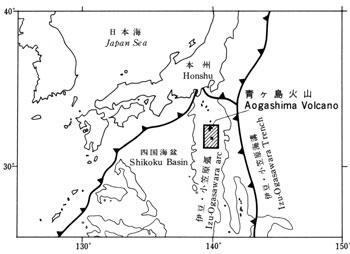
In the map area, the Pacific plate is subducting under the Philippine Sea plate at a steep angle of about 60? from the east. On the Philippine Sea plate near the boundary are developed Izu-Ogasawara volcanic arc of more than 1,200 km in length in NS direction ( ![]() Fig. 1 ). According to Hotta ( 1970 ), an island arc type crust about 15 km thick is developed in Izu-Ogasawara arc. Shichito-Iwojima Ridge represents major part of the arc with distribution of active volcanic islands and reefs in NS direction including Hachijojima, Aogashima, Myojinsho, Sumisujima and Torishima. One characteristic feature in the area is that all the volcanoes on the volcanic front are accompanied with calderas. In contrast, in the back-arc region to the west of the islands occur back-arc rifts elongated in NS cut by normal faults on either east or west sides ( Taylor et al., 1984 ). Within the rifts occur small volcanoes of cone or elongated shapes.
Fig. 1 ). According to Hotta ( 1970 ), an island arc type crust about 15 km thick is developed in Izu-Ogasawara arc. Shichito-Iwojima Ridge represents major part of the arc with distribution of active volcanic islands and reefs in NS direction including Hachijojima, Aogashima, Myojinsho, Sumisujima and Torishima. One characteristic feature in the area is that all the volcanoes on the volcanic front are accompanied with calderas. In contrast, in the back-arc region to the west of the islands occur back-arc rifts elongated in NS cut by normal faults on either east or west sides ( Taylor et al., 1984 ). Within the rifts occur small volcanoes of cone or elongated shapes.
This map was prepared based on our studies in addition to the existing data on volcanoes situated on the island arc such as Aogashima, those with submarine calderas, and those within the back-arc rifts. We hope the map is useful for future research of the area as well as mitigation of volcanic hazard and regional development.
Aogashima Volcano
If we assume its base is at 700 m depth, the basal diameter of Aogashima Volcano is 15 x 8 km with relative height of over 1,100 m and the total volume of 30 km3. The shape of the volcano above sea level is oval with its long axis about 3.5 km in NNW-SSE, short axis 2.5 km, and the estimated volume is only 3 km3. Southern half of the island is occupied by a large crater ( Ikenosawa crater about 100 m high ) of 1.7 x 1.5 km in size with a central cone ( Maruyama ). The somma surrounding the crater is 150 to 420 m high with the highest point being Ootonbu ( 423 m ) on the NE part of the somma. The northern half of the island consists of gentle slope tilting towards NNW ( height 250 to 300 m ) and is inhabited. The island is surrounded by erosional cliffs where the structure of stratovolcano is well exposed.
![]() PREV
PREV ![]() NEXT
NEXT