Aogashima Volcano
1: Introduction / Aogashima Volcano
2: Geology and geohistory of Aogashima Volcano / Activities in historical times before the years of Tenmei / Eruptions from 1781 to 1785
3: Rocks
4: Subsurface structures / Surveillance and observation of volcanic activities / Prediction of future activities and hazard
5: Volcanoes accompanying submarine calderas on island arc setting
6: Volcanoes within back-arc rift setting / Surveillance, observation, and prediction of future activities and hazard of submarine volcanoes
7: References
![]() PREV
PREV ![]() NEXT
NEXT
Volcanoes accompanying submarine calderas on island arc setting
Six submarine calderas exist between Aogashima and Hachijojima. Among them, Higashi-Aogashima caldera, Kita-Bayonnaise caldera, Myojinsho caldera, Sumisu caldera, and Minami-Sumisu caldera have been studied in detail with RV Hakureimaru ( Murakami and Ishihara, 1985 ). In recent years, Yuasa et al. ( 1991 ) reported that a depression in the east of Torishima Island is also a caldera ( Torishima caldera ). A small depression on top of a mound about 40 km to the east of Hachijojima may be another caldera as pointed out by Fujioka et al. ( 1992 ).
Higashi-Aogashima caldera : Higashi-Aogashima caldera is located about 12 km east of Aogashima ( lat. 32? 27' N,long. 139? 54' E ) with the size of about 5.4 x 9.9 km. The floor of the caldera is at 600 - 800 m deep and its diameter being about 4 x 7.3 km. The slope of caldera wall is rather gentle with the average of 14-20°. Overall shape including somma is oval with its long axis in NNE-SSW direction. The somma is enlarged at its north and south ends having No. 2 Aogashima knoll and No. 3 Aogashima knoll, respectively. According to sonar survey, the first layer is bedded and unconformably overlies the second layer within the caldera. The second layer is cut by a fault at caldera wall suggesting that the caldera was formed by collapse of the second layer. The caldera wall is dissected by erosion suggesting that this caldera is older than others in the region. Bouguer gravity anomaly shows highest value at the center of the caldera indicating that this caldera belongs to high gravity anomaly type. In the south of the caldera, a bipolar magnetic anomaly, with negative anomaly in the north and positive anomaly in the south, is identified.
Kita-Bayonnaise caldera : Kita-Bayonnaise caldera is located 40 km SSE of Aogashima at 32? 06' N,139? 51' E on top of Myojin knoll. The caldera wall and caldera floor are close to circular shape with 4.3 x 6.0 and 2.4 x 3.8 km across, respectively. It is thus smaller than the Higashi-Aogashima caldera. The caldera floor is about 1,300 m deep. It has a central cone. The highest point of the somma is 364 m deep but the somma is generally 600-700 m deep. The relative height of caldera wall is 700-900 m which is larger than other calderas and the slope of caldera wall is steeper at 20-30? than others. Sonar survey reveals that the first layer is stratified and its thickness is larger towards the area around caldera. The caldera wall consists of this layer without traces of fault. Therefore, the caldera may not be a collapse caldera but a crater of a volcano consisting of the first layer with 700 m thick. The Bouguer anomaly is largest at the center of the caldera suggesting that it is classified as high gravity anomaly type. No remarkable magnetic anomaly is recognized.
Myojinsho caldera : Myojinsho caldera is located at 31? 53' N, 139? 59' E and Myojinsho and Bayonnaise rocks are parts of its somma. Caldera wall is near circular with diameter of 7 - 9 km. The caldera floor is 5 - 6 km across and 900-1,000 m deep. Relative height of caldera wall is nearly 1,000 m and steeply sloping. Central cone is formed in the center of the caldera with the depth of its top at 330 m. Lower part of caldera wall is made up by the second layer cut by fault suggesting that it is a collapse caldera.
Myojinsho : Myojinsho is one of the most active volcanic reefs and many explosions have occurred there ( Morimoto and Ossaka, 1955; Ossaka, 1991 ). In 1896 a reef with lapping wave was observed, and in 1906 rising smoke was reported. In 1915 the water depth became only 10 m and submarine eruption occurred. In 1934 discoloration of water and sulfur smell were reported. In 1946 a new island about 200 x 150 m in size with height of 100 m was formed, but subsequently it subsided and just lapping wave was seen. During 1952 to 1953 large eruptions occurred repeatedly. On September 16th 1952, a new eruption commenced and a new island appeared on the next day, the 17th. The island grew to the size of 150 x 100 m with height about 30 m, and smoke rose up to 5,000 m on 21st. However, on the next day of 22nd it became just a small rocky reef. On 23rd, with rising smoke reaching 6,000 to 10,000 m the reef completely disappeared accompanying large explosion. A tsunami of 0.9 m high was observed at Yaene harbor of Hachijojima after 28 minutes of explosion. A research vessel, Kaiyomaru No. 5, from Maritime Safety Agency, was sunk with this explosion and 31 people were presumed to be killed. On 25th an ash fall was observed on the whole Hachijojima. In October another new island was formed and the height reached 120 m in 1953 at the highest. Between January and September, with repeated explosive activities new islands were formed and disappeared several times. In March explosions and rising smoke columns were sometimes visible from Aogashima and several tsunamis were observed at Hachijojima for about a week. A large explosion was visible on August 24th from Aogashima. In 1954 and 1955 explosions were recorded. In 1957 carcasses of deep sea fishes were seen drifting. In 1960, smoke rose to 2,000 to 3,000 m. After 10 years of quiescence explosions resumed and Kaitokumaru No. 2 while sailing nearby area reported that ‘on January 29th we observed discolored water with smell of sulfur. About 1 hour before explosion a strange sea rumbling was felt. We evacuated from the area at once.' Explosions continued intermittently from January 29th to May and outline of a round reef with lapping waves was visible occasionally. The top of lava dome reached about 10 m deep. On the explosion of April 23rd, a water column of 300-500 m long and 1,000 m high was observed with smoke rising up to 2,000 m. Just before the eruption of January, image of fish-finder showed a spine with diameter about 30 m at the center of lava dome of 200 m across reached about 40 m deep. The image of fish-finder in April just after the eruption, the top of the spine was found to be 50 to 55 m deep and a part about 100 m across and 60 m deep was missing. After those, discolored water has been observed in 1971, 1979, 1980, 1982, 1986, 1987, and 1988.
Sumisu caldera : Sumisu caldera is located at 31? 29' N,140? 03' E. Sumisu Island with 136 m a.s.l. is a part of its somma. The caldera wall is near circular with 6.6 x 8.3 km across and the floor is 5.0 x 6.2 km in size with the depth of floor being 800-900 m. Relative height of the wall is about 700 m at maximum with its steep slope at 32? in average. The first layer is stratified but on the eastern slope the stratification is somewhat irregular suggesting submarine land slide. The second layer is cut by fault at caldera wall indicating the collapse as its origin. Bouguer anomaly is higher at the center by about 25 mgal than surrounding area which indicates the caldera as high gravity anomaly type. Dipole type magnetic anomaly with negative in the north and positive in the south is identified in the vicinity of Sumisu Island. To the SW of Sumisu Island in 1870, a new island appeared and in 1916 sound of explosion with ash fall was recorded. According to sonar depth record, the island was disappeared in 1923. Discolored water was observed in 1975, 1976, and 1977.
Minami-Sumisu caldera : Minami-Sumisu caldera is a small caldera located about 20 km south of Sumisu Island at 31? 16' N,140? 04' E. The shape is circular with 2 x 3 km in diameter. The caldera floor is 1 x 2 km with depth at 842 m at maximum. Depths of somma is 270 - 500 m. The first layer is stratified and thick. The somma consists of the thick first layer and the layer is exposed on the wall. No fault was observed cutting caldera wall. These characteristic points are the same with those of Kita-Bayonnaise caldera.
Torishima caldera : Torishima caldera is situated at about 5 km NNE of Torishima Island at 30? 32' N,140? 20' E. The diameter of the caldera edge is about 4 km with floor diameter 1 km. Maximum water depth of the floor is 660 m making relative height 480 m. Torishima Island corresponds to southern somma of this caldera. Maximum sloping angle of the wall is 20? and the slope tends to be steeper on SW side. The wall is breached on NW side making the caldera horse shoe shape. The first layer is stratified and covers the second layer at places of caldera wall. The wall does not seem to be cut by fault. From these characteristics the caldera might have been formed not by collapse but breaking up of the volcanic body.
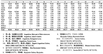
Rocks of submarine calderas : Submarine calderas described above consist mostly of acid volcanic rocks but basalt also occur in some of them showing activities of bimodal rock types ( ![]() Table 1 ). In Higashi-Aogashima and Kita-Bayonnaise calderas andesitic rocks also occur. In Higashi-Aogashima caldera, orthopyroxene dacite and ortho- and clino-pyroxene andesite are found on caldera wall. In Kita-Bayonnaise caldera, common hornblende-bearing clino- and ortho-pyroxene dacite is collected from caldera wall while from outside slope of somma clino- and ortho-pyroxene andesite are collected. In Myojinsho caldera, ortho-and clino-pyroxene basalt from Bayonnaise Rocks, clino- and ortho-pyroxene dacite from Myojinsho, and ortho- and clino-pyroxene dacite from central cone are collected. In Sumisu caldera, occur orthopyroxene-clinopyroxene dacite at central cone and caldera wall, and olivine basalt and clinopyroxene dolerite at Sumisu Island. In Minami-Sumisu caldera occur clinopyroxene dacite and orthopyroxene-clinopyroxene rhyolite on caldera wall and common hornblende rhyolite at a knoll east of somma.
Table 1 ). In Higashi-Aogashima and Kita-Bayonnaise calderas andesitic rocks also occur. In Higashi-Aogashima caldera, orthopyroxene dacite and ortho- and clino-pyroxene andesite are found on caldera wall. In Kita-Bayonnaise caldera, common hornblende-bearing clino- and ortho-pyroxene dacite is collected from caldera wall while from outside slope of somma clino- and ortho-pyroxene andesite are collected. In Myojinsho caldera, ortho-and clino-pyroxene basalt from Bayonnaise Rocks, clino- and ortho-pyroxene dacite from Myojinsho, and ortho- and clino-pyroxene dacite from central cone are collected. In Sumisu caldera, occur orthopyroxene-clinopyroxene dacite at central cone and caldera wall, and olivine basalt and clinopyroxene dolerite at Sumisu Island. In Minami-Sumisu caldera occur clinopyroxene dacite and orthopyroxene-clinopyroxene rhyolite on caldera wall and common hornblende rhyolite at a knoll east of somma.