Aogashima Volcano
1: Introduction / Aogashima Volcano
2: Geology and geohistory of Aogashima Volcano / Activities in historical times before the years of Tenmei / Eruptions from 1781 to 1785
3: Rocks
4: Subsurface structures / Surveillance and observation of volcanic activities / Prediction of future activities and hazard
5: Volcanoes accompanying submarine calderas on island arc setting
6: Volcanoes within back-arc rift setting / Surveillance, observation, and prediction of future activities and hazard of submarine volcanoes
7: References
![]() PREV
PREV ![]() NEXT
NEXT
Volcanoes within back-arc rift setting / Surveillance, observation, and prediction of future activities and hazard of submarine volcanoes
Volcanoes within back-arc rift setting
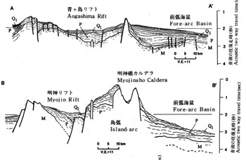
Back-arc rift area shown in this map is subdivided into four subareas based on topography and structure; that is, from north Hachijo rift, Aogashima rift, Myojin rift, and Sumisu rift. In ![]() Fig. 6 are shown EW sonar profiles of these rifts. The boundary faults in EW direction separating these areas cut P layer indicating that the rifts were formed after the deposition of P layer. Many normal faults develop within each area and some of them cut topmost Q1 layer. Normal faults including those separating areas within the depression are in the directions from N25°E to N30°W showing prevalence of NS trend. In Minami-Sumisu basin south of Sumisu rift, several active faults with NS tend have been reported ( Murakami, 1988 ). The upper layers of deposits in Minami-Sumisu basin are derived from either submarine caldera or back-arc basin and consisting mainly of pumice layers according to submarine drilling. The pumice layers consist of five units and each was dated by paleomagnetic and micro-paleontological methods to be 1,000, 31,000, 61,000, 67,000, and 131,000 years BP, respectively ( Nishimura et al., 1992 ). Vertical displacement of each layer by active faulting is larger in the lower layer than the upper one showing that the fault movement has continued during the deposition.
Fig. 6 are shown EW sonar profiles of these rifts. The boundary faults in EW direction separating these areas cut P layer indicating that the rifts were formed after the deposition of P layer. Many normal faults develop within each area and some of them cut topmost Q1 layer. Normal faults including those separating areas within the depression are in the directions from N25°E to N30°W showing prevalence of NS trend. In Minami-Sumisu basin south of Sumisu rift, several active faults with NS tend have been reported ( Murakami, 1988 ). The upper layers of deposits in Minami-Sumisu basin are derived from either submarine caldera or back-arc basin and consisting mainly of pumice layers according to submarine drilling. The pumice layers consist of five units and each was dated by paleomagnetic and micro-paleontological methods to be 1,000, 31,000, 61,000, 67,000, and 131,000 years BP, respectively ( Nishimura et al., 1992 ). Vertical displacement of each layer by active faulting is larger in the lower layer than the upper one showing that the fault movement has continued during the deposition.
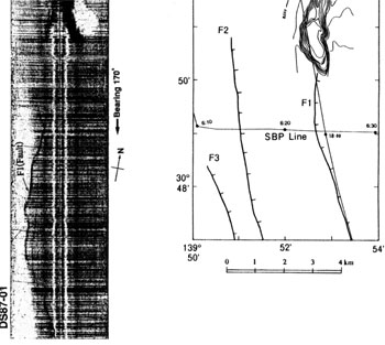
Volcanoes of back-arc rift zone are topographically classified into two types; one is cones and the other elongated ridge in NS direction. The sizes of those are smaller than those on the volcanic front. Conical volcanoes are smaller than those in volcanic front by several km in diameters while lengths of ridge volcanoes are less than 15 km. Distribution of conical volcanoes is restricted and they tend to occur only on the basement highs in the western areas. Ridge type volcanoes tend to cluster in the axial parts which correspond to youngest and most active areas of the rifts. Also some occur along normal faults within the rifts. For example, along an active fault in Minami-Sumisu basin in Sumisu rift, basalt pillow lava is found. It extrudes through the sediments forming a high of about 100 m with EW width of about 800 m and NS length of about 5 km ( ![]() Fig. 7 ). Basalt of conical and ridge type volcanoes within the Sumisu rift has been dated to be about 0.6 Ma and 0.3 Ma, respectively with K-Ar method ( Hochstaedter et al., 1990 ).
Fig. 7 ). Basalt of conical and ridge type volcanoes within the Sumisu rift has been dated to be about 0.6 Ma and 0.3 Ma, respectively with K-Ar method ( Hochstaedter et al., 1990 ).
Chemically, the back-arc volcanism produced bimodal compositions ( Ikeda and Yuasa, 1989; Fryer et al., 1990; Yamazaki et al., 1991 ). In Hachijo rift, olivine-bearing clinopyroxene basalt and rhyolite, in Aogashima rift clinopyroxene olivine basalt and quartz-bearing ortho- and clino-pyroxene rhyolite, and in Sumisu rift rhyolite, clinopyroxene olivine basalt, and clinopyroxene olivine dacite occur ( ![]() Table 1 ).
Table 1 ).
Surveillance, observation, and prediction of future activities and hazard of submarine volcanoes
Regular monitoring is not possible as the area is located in the middle of ocean. In the past reporting of any anomalous phenomena such as discolored water, strange smell, and floating objects such as pumice were mostly obtained haphazardly from ships passing the area. However, in recent years surveillance with satellite has been increasingly widely used. If anomalous phenomenon is observed, air-borne survey, submarine topographic survey using sonar, and chemical analysis of volcanic gas and rocks are carried out. At times sea bottom seismograph and hydrophone are employed.
A volcano in the sea, with its top is just above the sea or very shallow, tends to cause phreatomagmatic explosion. The depth of the top would change with time. Therefore it should be closely watched. At the moment an area around Myojinsho is most active. As mentioned before, a submarine eruption may be accompanied with tsunami. From the experiences obtained from on-land volcanoes along with the existence of thick pumice beds, a large explosion is a distinct possibility. Unfortunately our geologic knowledge at the moment is hampered by the fact that the location of the volcanoes being in the sea.

