Kusatsu-Shirane Volcano
Introduction / Geology of Kusatsu-Shirane Volcano and environs / Geology of Kusatsu-Shirane Volcano
Eruptions of historical times
Rocks of Kusatsu-Shirane Volcano
Geochemistry of Kusatsu-Shirane Volcano
Compositions of volcanic gasses and their variation
Prediction of eruption, mitigation of hazard,
and benefit of volcano
Acknowledgment / References / Postscript
![]() PREV
PREV ![]() NEXT
NEXT
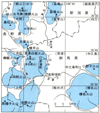
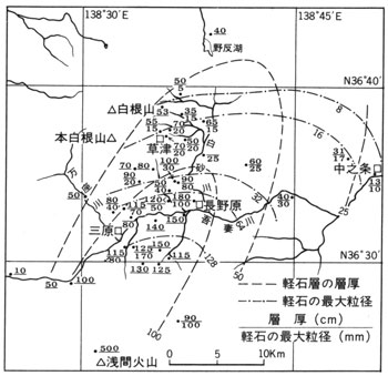
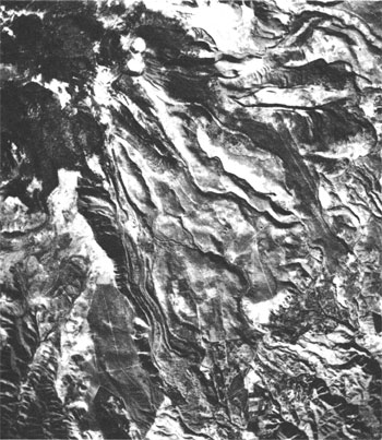
Fig.3 B Remarkable surface features as craters and linear depressions on lava surface.
Introduction / Geology of Kusatsu-Shirane Volcanoes and environs / Geology of Kusatsu-Shirane Volcano
Introduction
Kusatsu-Shirane Volcano is situated near the boundary of northern Gunma and Nagano Prefectures and constitutes an important part of Joshin-etsu National Park. Many people visit the area all year round for activities such as sightseeing, hiking, and skiing. The volcano is one of the more active one in Japan and thirteen eruptions since 1805 ( second year of Bunka ) have been recorded. In recent years the activity is more or less restricted to phreatic eruptions occurring around Yugama and Mizugama near Shirane pyroclastic cone, but fumarolic activities are furious in many parts. The area used to be a center of sulfur production and at one time there were 5 mines, all of which have now closed down. Even now at the bottom of Yugama pond, molten sulfur is seen accumulated. In Sesshogawara and Manzazawa, strong sulfuric smell prevail and sublimed sulfur crystallizing on the surface of rocks and rocks altered by sulfuric activities are widely exposed in yellows and browns. Around the volcano hot spa resorts such as Kusatsu and Manza exist. They are famous for abundant hot water supply of strong acid nature containing various sulfates. A highway passes near Shirane pyroclastic cone, and because of easy access many sightseers visit and look into Yugama crater. However, as mentioned before, volcanic activity around Yugama is still vigorous and several casualties were resulted from phreatic eruption in 1932. Also around Sesshogawara, Manzazawa, and elsewhere, poisoning from hydrogen sulfide gas was recorded. Therefore, it is important to be alert for these hazards. The geologic map is a compilation of geologic and volcanic-chemical studies of Kusatsu-Shirane Volcano. We hope the map is utilized for not only scientific studies but also for prevention-mitigation of hazard from volcanic activity, regional development, and sight seeing.
Geology of Kusatsu-Shirane Volcanoes and environs
Many Quaternary volcanoes are distributed in an area between Gunma and Nagano Prefectures. All are andesitic stratovolcanoes. To the south are Asama and Eboshi Volcanoes, to the west Azumaya and Omeshi Volcanoes, to the north Shiga (Shiga Kogen), Takayashiro, Kenashi, Yakebitai, and Naeba Volcanoes, and to the east Haruna, Onogo, and Komochi Volcanoes. This is an area where volcanoes are most densely concentrated in Japan ( ![]() Fig.1 ). Among them Asama and Kusatsu-Shirane Volcano are the only ones with historical records of eruptions.
Fig.1 ). Among them Asama and Kusatsu-Shirane Volcano are the only ones with historical records of eruptions.
The basement of this area consists of Neogene volcanic rocks and they are widely distributed around Kusatsu-Shirane Volcano. The total thickness of Neogene volcanic rocks seems to be more than 1,000 m. Most of the rocks are andesitic and regionally altered with hydrothermal alteration including silicification showing green and brown colors. The rocks distributed within this map area are andesitic to dacitic from Neogene volcanics to the latest eruption products of Kusatsu-Shirane Volcano. Because of this it is rather difficult to judge which belongs to basement and which belongs Kusatsu-Shirane based on lithology alone. Here if the rocks are widely distributed and strongly altered they were judged to belong to basement, while rocks overlying the basement and found only around Kusatsu-Shirane ( such as Matsuozawa lava ) were judged to belong to Kusatsu-Shirane Volcano.
The highest exposure of the basement rocks is to the NW of Kusatsu-Shirane Volcano at 2,000 m a.s.l. forming the boundary ridge between Gunma and Nagano Prefectures. On the other hand, the basement rocks are only found in low lying areas below 1,100 m in the east and south such as near Motoyama ( north of Kusatsu Spa ) and near Mihara ( south of Ishizu ). Therefore, Kusatsu-Shirane Volcano seems to have been formed on the east- and southward gently tilting basement surface. On the westside of the highest points of the volcano, Shiranesan and Moto-Shiranesan, the basement rocks are steeply dipping toward the western valley. The rocks here have suffered heavily with hydrothermal alteration and silicification and weak to erosion. It seems that the erosion reached to the point where the altered basement rocks were protected by fresh Kusatsu-Shirane rocks, which cover the weak basement, resulting in steep slope.
Near Yokoteyama, immediately north of Shirane pyroclastic cone, andesitic lava is distributed sloping gently to the east on the basement. As the degree of erosion of lavas on this slope is at about the same degree with older lava of Kusatsu-Shirane Volcano ( such as Komenashi Lava and Udogasawa Lava ), it is believed that the age of the lava is about the same with the latter. However, the crater from which this lava was erupted is distinctly different from the center of eruption of current Kusatsu-Shirane suggesting it belongs to Yokote Volcano, but not to Kusatsu-Shirane. To the north of Yokote Volcano is Shiga ( Shiga Kogen ) Volcano with very fresh volcanic topography.
Geology of Kusatsu-Shirane Volcano
Kusatsu-Shirane Volcano consists of several units. In the west, three pyroclastic cones ( 0.33 m3 ) belonging to the younger activities. Lavas flowing out from there radially to the east and south ( about 7 km3 ), and pyroclastic flow deposits forming vast fan base in the east and south ( 10 km3 ). As mentioned before, Kusatsu-Shirane Volcano was formed on the east and southward sloping basement. The ejecta (lavas and pyroclastic flow deposits) were distributed in the east and south of the crater showing asymmetrical distribution. Judged from the distribution of ejecta of different ages, the position of craters seems to have been fixed on the line connecting Moto-Shirane pyroclastic cone and Shirane pyroclastic cone.
The earliest eruption of Kusatsu-Shirane Volcano occurred about 2 million years before the present. Matsuozawa lavas were erupted from somewhere near Moto-Shiranesan and seem to have formed a stratovolcano. After a long erosional period, Horaguchi Lava erupted. This is now mostly covered by Oshi pyroclastic flow deposits and the original distribution is unknowable.
Horaguchi Lava eruption was followed by activity of Oshi pyroclastic flow which covered wide area. This pyroclastic flow shows variable appearances from non-welded to strongly welded even in the same exposure. It forms flat-lying plateau like at Moto-Shirane Farm and Sennoiri on one hand, and steep river cliffs over 50 m high at Yazawagawa River and Kosamegawa River on the other hand.
Lavas after the eruption of Oshi pyroclastic flow are classified into three stages ( Older, Middle, and Younger ) according to their ages. Older lavas ( Komenashi and Udogasawa lava ) erupted from near Moto-Shirane as their eruptive center, and form gentle slopes to west and south. East side of Komenashiyama is a steep cliff facing Imai River, but the reason why this steep cliff is formed is not known.
After the formation of this steep cliff, Middle stage lavas ( Aoba Lava, Heibei-ike Lava, Futagoyama Lava Dome, and Shirane Lava ) erupted. Aoba Lava consists of several flow units and understood to have erupted from several craters at about the same time to east and southeast and shows fan-like distribution. As the thickness of single lava is over 100 m it shows topography of stacked flat surfaces. Heibei-ike Lava, like Aoba Lava, consists of several thick lava flows and lithology is similar to that of Aoba Lava. However, because it shows different distribution and fresh surface, it is a different geologic unit. It is possible that this was erupted slightly later than Aoba Lava. Near the summit, Shirane Lava and Futago-ike Lava Dome formed on Aoba Lava and Heibei-ike Lava. After the eruptions of those Middle stage lavas, thick volcanic ash ( 4-5 m thick ) deposited with Kusatsu Township as the center of distribution. The source of this ash is not known yet. Probably the source is either Kusatsu-Shirane or Asama Volcano. Following these, pyroclastic flow ( Yazawahara pyroclastic flow ), though little in volume, erupted to form a fan-shaped plateau ( Yazawahara ) to the north of Kusatsu Township. After the activities of Middle stage lavas and Yazawahara pyroclastic flow, Kusatsu-Shirane Volcano seems to have experienced a period of quiescence for about 200,000 to 300,000 years.
About 11,000 years ago at Asama Volcano, next to Kusatsu-Shirane to the south, a large eruption occurred and a great volume of pumice fell in Kusatsu Township. The pumice is named as Tsumagoi pumice fall. The thickness decreases with the distance from Asama and about 90 cm at Sennnoiri and 50 to 70 cm in central Kusatsu ( ![]() Fig.2 ). Yellow colored slightly weathered coarse-grained ( 1-3 cm ) pumice is exposed as densely packed state on roadside exposures.
Fig.2 ). Yellow colored slightly weathered coarse-grained ( 1-3 cm ) pumice is exposed as densely packed state on roadside exposures.
Younger activities of Kusatsu-Shirane Volcano commenced at about the same time with that of Tsumagoi pumice fall. Details of topographic features of lava flows such as lava levees and lava wrinkles are clearly shown on air photos ( ![]() Fig.3 ). Among the younger lavas, Sessho Lava overlies Tsumagoi pumice fall indicating it is younger than 11,000 years. Other lavas judged to belong to Younger lava show similar freshness in topographic features. Therefore their age of eruption was estimated to be about 10,000 years or younger. Near the source craters of Younger lavas, eruption of essential and accidental materials formed three N-S aligned pyroclastic cones ( Moto-Shirane and Shirane composite pyroclastic cones and Aino-mine pyroclastic cone ). After this, activity of Kusatsu-Shirane Volcano has been restricted to an area from Yumi-ike to Shirane pyroclastic cone and large and small explosion craters were formed by phreatic explosions. This type of activity continues to this day.
Fig.3 ). Among the younger lavas, Sessho Lava overlies Tsumagoi pumice fall indicating it is younger than 11,000 years. Other lavas judged to belong to Younger lava show similar freshness in topographic features. Therefore their age of eruption was estimated to be about 10,000 years or younger. Near the source craters of Younger lavas, eruption of essential and accidental materials formed three N-S aligned pyroclastic cones ( Moto-Shirane and Shirane composite pyroclastic cones and Aino-mine pyroclastic cone ). After this, activity of Kusatsu-Shirane Volcano has been restricted to an area from Yumi-ike to Shirane pyroclastic cone and large and small explosion craters were formed by phreatic explosions. This type of activity continues to this day.
![]() PREV
PREV ![]() NEXT
NEXT