Kuju Volcano
1: Introduction - 2: Topography
3: Eruptive history of Kuju Volcano
4: Historic eruptions
5: Petrological characteristics of products
6: Hot springs and geothermal and ore deposits - 7: Current activities and observation system - 8: Characteristics of eruption activities and precautions taken in volcanic disaster prevention
Acknowledgements / References
![]() PREV
PREV ![]() NEXT
NEXT
1: Introduction - 2: Topography
1: Introduction
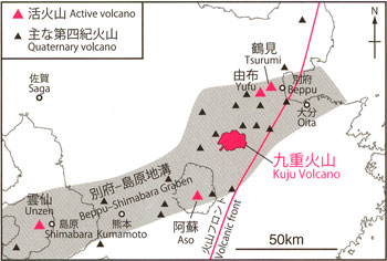
Kuju Volcano is an active volcano located on the volcanic front of central Kyushu in the Beppu–Shimabara Graben, which extends from Beppu Bay through the Sea of Ariake to the Shimabara Peninsula ( ![]() Figure 1).
Figure 1).
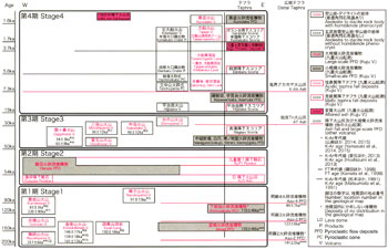
Small-scale eruptions released altered ashes during 1995 to 1996 in the vicinity of Hosshozan at the central part of Kuju Volcano. No significant magmatic eruptions have been recorded during historic times; however, volcanic activity approximately 1,600 years ago produced an andesite lava dome. The geology of Kuju Volcano on the east side has been discussed by Ono (1963) and Ohta (1991); the western parts were discussed by Kamata (1997); and the tephrostratigraphy was discussed by Kamata and Kobayashi (1997) and Nagaoka and Okuno (2014). Therefore, the volcanic history of Kuju Volcano has been largely outlined. In this geological map, we reconstructed a more detailed history of the volcanic activities. In order to predict the transition in future eruptions, we conducted field survey with air-photo interpretation, whole-rock chemical analysis, and K-Ar and 14C dating, and we summarized the results. For the formation age of each eruptive unit, we essentially used the K-Ar age of rock samples collected from the unit (Narukoyama and Kutsukakesan volcanos and Iozan Lava: Yamasaki et al., 2014; the others: Yamasaki et al., 2015; ![]() Figure 2). For the units without obtained K-Ar ages, we referred to the thermoluminescence (TL) ages reported by Okuno et al. (2013b). For 14C ages, we used ages corrected for the calendar year, which are expressed in the units of ka (1,000 years ago).
Figure 2). For the units without obtained K-Ar ages, we referred to the thermoluminescence (TL) ages reported by Okuno et al. (2013b). For 14C ages, we used ages corrected for the calendar year, which are expressed in the units of ka (1,000 years ago).
2: Topography
The volcanic edifice of Kuju Volcano extends approximately 13 km east–west and approximately 10 km north–south and divided into east, central, and west regions based on the topography. The mountains in the east part consist of Kurodake (elevation: 1,587 m), Taisenzan (1,786 m), and Hiijidake (1,643 m); those in the central part include Nakadake (1,791 m), Kujusan (1,787 m), Mimatayama (1,744 m), Hosshozan (1,762 m), and Ogigahana (1,698 m), and those in the west part consist of Kuroiwasan (1,503 m), Gotozan (1,384 m), and Ryoshiyama (1,423 m). Among these mountains, Nakadake has the highest peak in Kyushu. The volcanic edifice consists of small-scale stratovolcanoes and lava domes composed of basaltic andesite to dacite. The edifice in the west region has been dissected significantly by erosion. In the eastern section, however, fresh features composed of thick lava flows and lava domes are present at Taisenzan and Kurodake. The lowlands between these edifices include Tadewara, Bougatsuru, and Sadogakubo marshes, which formed through damming by lava flows and debris avalanche deposits (Chida, 2002).
Volcanic fans are widely distributed at the foot of Kuju Volcano, consisting of small-scale block and ash flow deposits, debris avalanche deposits, and lahar deposits. In addition, large-scale pyroclastic flow deposits such as Miyagi, Shimosakata, and Handa are present, all derived from Kuju Volcano. Within the area of this geologic map, Miyagi and Handa Pyroclastic Flow Deposits are present.
![]() PREV
PREV ![]() NEXT
NEXT