Kuju Volcano
1: Introduction - 2: Topography
3: Eruptive history of Kuju Volcano
4: Historic eruptions
5: Petrological characteristics of products
6: Hot springs and geothermal and ore deposits - 7: Current activities and observation system - 8: Characteristics of eruption activities and precautions taken in volcanic disaster prevention
Acknowledgements / References
![]() PREV
PREV ![]() NEXT
NEXT
3: Eruptive history of Kuju Volcano
3.1: Outline
Around Kuju Volcano, volcanic rocks older than this volcano (ca. 2 to 0.3 Ma) are present. In the eastern section, Kakura Andesite (ca. 2 Ma), Tokisan Andesite (ca. 0.7 Ma), Kamitoge Rhyolite, the Nakatoge Pyroclastic Flow Deposit (both ca. 0.6 Ma), and Hanamureyama Volcano (ca. 0.5Ma) are found. The western section includes the Waitasan Volcano Group (ca. 1.0 to 0.3 Ma), which includes Otake Andesite; Shibayakatatoge Andesite (ca. 0.6 Ma) is also present. Some of these volcanic rocks were originally included in Kuju Volcano (Notomi, 1920; Matsumoto, 1983). However, Kamata (1997) defined Kuju Volcano which is younger than the Miyagi Pyroclastic Flow Deposit (ca. 130 ka), extending from Kurodake to the east and Ryoshiyama to the west. In this geologic map, we refer the same area described by Kamata (1997) as Kuju Volcano, although the beginning of its active period is shown to be older than the Miyagi Pyroclastic Flow Deposit at ca. 200 ka. An approximately 100,000-year gap was reported among the rocks of the Waitasan Volcano Group.
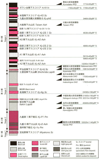
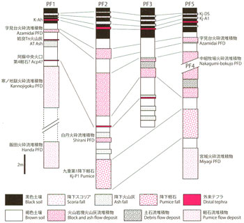
In this geologic map, we define the eruption stages of Kuju Volcano from the Stages 1 to 4. ![]() Figure 2 shows the stratigraphic succession for the geological units.
Figure 2 shows the stratigraphic succession for the geological units.
Stage 1 refers to the beginning of Kuju Volcano activity to prior to the Handa Pyroclastic Flow Deposit (ca. 200–54 ka). The mountains in the western section such as Kuroiwasan, Gotozan, and Ryoshiyama and some in the central section such as Kutsukakesan, Narukoyama, and Iozan were formed. Stage 2 refers to the eruptive activity of the Handa Pyroclastic Flow Deposit (ca. 54 ka) including eruptions of ash fall, pumice fall, and pyroclastic flow. During Stage 3, volcanic activities following the Handa Pyroclastic Flow Deposit formed Ogigahana, Hosshozan, Nakadake, and Mimatayama in the central section and Dainoyama (ca. 54–15 ka) at the base of the eastern section. From Stage 1 to Stage 3, most volcanic rocks are hornblende andesite and some dacite. Stage 4 was an active period following the eruption of mafic magma that began in Hiijidake in the eastern section at ca. 15 ka. In this stage, Hiijidake, Taisenzan, Kitataisenzan, and Kurodake were mainly formed in the eastern section of Kuju Volcano. In addition, pyroclastic flows occurred in the central section. A large amount of mafic magma without hornblende phenocrysts was characteristic. Moreover, there was a small-scale (magmatic) phreatic eruption occurred in the central section in addition to magmatic eruption (ca.15–0 ka).
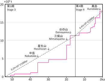
The volume of eruption products during Stage 4 was approximately 0.45 × 10⁹ t/ky, increasing from the approximately 0.29×10⁹ t/ky ejected in Stage 3 ( ![]() Figure 3).
Figure 3).
3.2: Tephra derived from Kuju Volcano
![]() Figure 4 shows tephra derived from Kuju Volcano.
Figure 4 shows tephra derived from Kuju Volcano. ![]() Figure 4 also shows stratigraphic positions and ages of pyroclastic flow deposits. In this section, we provide a simple overview of this widespread tephra.
Figure 4 also shows stratigraphic positions and ages of pyroclastic flow deposits. In this section, we provide a simple overview of this widespread tephra.
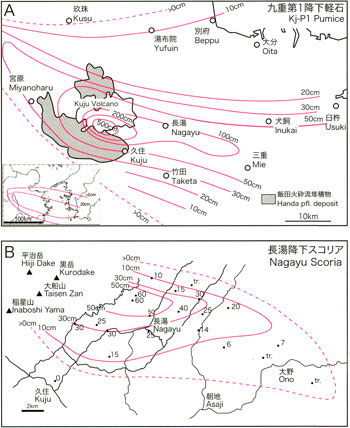
Kj-P1 Pumice, found extensively in Oita Prefecture to the east of Kuju Volcano, is a hornblende–dacite Plinian pumice fall deposit that reaches about 6 km3 (Ono, 1963; Machida, 1980; Nagaoka and Okuno, 2014). As discussed subsequently, this pumice layer is from the largest Plinian eruption that occurred at Kuju Volcano ca. 54 ka based on the 14C ages (Okuno et al., 2013a) ( ![]() Figure 5A).
Figure 5A).
Nagayu Scoria (Kj-Ng), a pyroxene andesite scoria fall deposit, occurs immediately under the dark band that forms within the brown loam in the upper part of Kj-P1 extending from Kuju Volcano to the eastern part of Aso Volcano. Its axis of distribution extends from the area near Nagayu Hot Spring in Taketa City to Ono, Bungo-Ono City, in an east–southeastern direction ( ![]() Figure 5B). AT Ash (29 ka) is present in the upper portion of the dark band. The source of eruption is believed to be the present-day Hiijidake to Dainoyama area, although no outcrop of pyroxene andesite of about 30 ka is present in the surrounding area. Therefore, it is assumed that the source volcano is present under Dainoyama Volcano. The volume of products determined by the method of Hayakawa (1985) was approximately 0.2 km3, and the 14C ages of Kj-Ng after the calendar year correction is 30 ka.
Figure 5B). AT Ash (29 ka) is present in the upper portion of the dark band. The source of eruption is believed to be the present-day Hiijidake to Dainoyama area, although no outcrop of pyroxene andesite of about 30 ka is present in the surrounding area. Therefore, it is assumed that the source volcano is present under Dainoyama Volcano. The volume of products determined by the method of Hayakawa (1985) was approximately 0.2 km3, and the 14C ages of Kj-Ng after the calendar year correction is 30 ka.
Since the end of Pleistocene, activities in the eastern section of Kuju Volcano increased, and tephra was found even near the foot. Among these deposits, Danbaru Scoria (Kj-DS; Ohta, 1991) is scoria fall deposit, characterized by orange scoria scattered across two horizons in black soil that is widely distributed around the foot. Closer to Taisenzan, the number of scoria layers increases; at least five layers of scoria falls are confirmed. The eruption source is estimated to be the Danbaru crater of Kitataisen Volcano owing to its distribution and petrological characteristics. Its age of activity is estimated to be 5.6–5.4 ka. In addition, Komekubo Scoria (Kj-KS), andesite originated from Komekubo Volcano, and the Garandai Scoria Fall Deposit (Kj-GS; 1.7 to 1.6 ka), which is basaltic andesite, are found on the Taisenzan mountainside. Their isopachs are shown in the geological map.
Near the peak of Kuju Volcano, multiple layers of altered ashes occur that are associated with the phreatic eruption discussed subsequently (Itoh et al., 2014). One of the larger scale altered ash layers is the 3.9–3.5 ka Kuju Phreatic Deposit 6 (Kj-ph 6; Itoh et al., 2014). Its isopach is shown in the geological map.
3.3: Stage 1 (activities prior to Handa Pyroclastic Flow Deposit)
Products of Stage 1 include that of Ryoshiyama, Goutouzan, and Kuroiwasan volcanoes in the western section and Kutsukakesan and Narukoyama volcanoes and Iozan Lava in the central section. Many of these volcanic edifices are covered by the Handa Pyroclastic Flow Deposit. Ryoshiyama Volcano was formed ca. 200 ka and has been dissected which composed of lava domes and pyroclastic rocks. Kutsukakesan Volcano consists of a hornblende andesite to dacite edifice with lava flows of hornblende andesite that flowed southward. The K-Ar age is ca. 160 ka. For Kuroiwasan Volcano, a K-Ar age of ca. 85 ka and a TL age of ca. 80–30 ka have been reported. To the north of Kuroiwasan, a small amount of Bungonowatashi Pyroclastic Flow Deposit derived from Kuroiwasan is distributed (Kamata, 1997). Narukoyama Volcano is a dissected stratovolcano consisting of hornblende andesite. The foot of the volcano is covered by Kj-P1 and Kuju D Ash Fall (Kj-D); a K-Ar age of ca. 90 ka has been obtained. Iozan Lava is dacite lava located on the east side of Hosshozan with a K-Ar age of ca. 150 ka; the same age has been determined for Kutsukakesan Volcano.
During the activity of Stage 1, Miyagi and Shimosakata Pyroclastic Flow Deposits erupted from Kuju Volcano. The Miyagi Pyroclastic Flow Deposit is present to the southeast of the geological map and extends to the areas near Kamitajiri in Ubuyama Village and Sumikamado areas in Taketa City outside of this map (Ono et al., 1977; Kamata, 1997). The Shimosakata Pyroclastic Flow Deposit is also found from Kamisakata to Shimosakata in
Taketa City (Ono et al., 1977).
The ages of the Miyagi Pyroclastic Flow Deposit and the Shimosakata Pyroclastic Flow Deposit are approximately ca. 130 ka and ca.110 ka, respectively, based on the stratigraphic relationship with the Aso Pyroclastic Flow Deposit and the dating results ( ![]() Figure 2). These two pyroclastic flow deposits and the Handa Pyroclastic Flow Deposit all consist of dacite pumice with a very small amount of andesite scoria. Their whole-rock compositions are quite similar. The Miyagi Pyroclastic Flow Deposit on the southeastern part of the geological map contains hornblende dacite pumice along with small amounts of scoria and banded scoria. These are either not welded or only weakly welded, and they sandwich the brown loam with a thickness of 2–3 m, while being covered by Kj-P1. Miyagi Pyroclastic Flow Deposit distributed near Kanba in Taketa City outside of this geological map are covered by the Aso-3 Pyroclastic Flow Deposit. A direct stratigraphic relationship with Miyagi Pyroclastic Flow Deposit and other products of Stage 1 is unknown. Based on the dating results, however, the Miyagi Pyroclastic Flow erupted during Stage 1.
Figure 2). These two pyroclastic flow deposits and the Handa Pyroclastic Flow Deposit all consist of dacite pumice with a very small amount of andesite scoria. Their whole-rock compositions are quite similar. The Miyagi Pyroclastic Flow Deposit on the southeastern part of the geological map contains hornblende dacite pumice along with small amounts of scoria and banded scoria. These are either not welded or only weakly welded, and they sandwich the brown loam with a thickness of 2–3 m, while being covered by Kj-P1. Miyagi Pyroclastic Flow Deposit distributed near Kanba in Taketa City outside of this geological map are covered by the Aso-3 Pyroclastic Flow Deposit. A direct stratigraphic relationship with Miyagi Pyroclastic Flow Deposit and other products of Stage 1 is unknown. Based on the dating results, however, the Miyagi Pyroclastic Flow erupted during Stage 1.
3.4: Stage 2 (Handa Pyroclastic Flow Eruption)
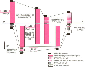
The Handa Pyroclastic Flow Deposit is the product from the largest eruption of Kuju Volcano and is believed to have erupted from the central part of the current Kuju Volcano (Kamata and Mimura, 1981). The eruptive activities of this flow deposit are divided into an early stage consisting of small-scale pyroclastic falls; a middle stage, which is the climax of the pyroclastic flow eruptions; and a late stage, which includes small-scale pyroclastic flow eruptions occurring at the same time as the Kj-P1 or later ( ![]() Figure 6).
Figure 6).
Eruptive activities in the early stage began with a small-scale scoria eruption. This event was followed by deposit of stratified blue–gray ash of Kj-D, which contains two layers of gray–white volcanic ash layers with mixed pumice. The lower volcanic ash layer is compared to a pumice layer consisting mainly of low-porosity pumice of the Yutsubo Pumice Fall (Kj-Yu) found in the northwestern part of Kuju Volcano. In the middle stage, a large-scale eruption of pyroclastic flow occurred that contained a large amount of dacite pumice to form the lower part of the Handa Pyroclastic Flow Deposit. The lower part of the Handa Pyroclastic Flow Deposit contains a large amount of volcanic blocks with cooling joints and pumice. During the eruption, the formation and destruction of lava domes were repeated. In the late stage, Plinian plumes deposited a thick Kj-P1 layer mainly to the east. In Kuju Kogen, Kj-P1 is observed to directly cover the lower part of the Handa Pyroclastic Flow Deposit. The pumice of Kj-P1 is andesite to dacite characterized by a large amount of dark inclusions. The upper part of the Handa Pyroclastic Flow Deposit occurred during the fall of Kj-P1 or later, includes pumice that is similar to Kj-P1 and the dark inclusions. In the areas near the source such as Kuroiwasan and Senomoto, the deposit exhibits weakly stratified lithofacies or surges. As the distance from the volcanic edifice increases, it changes to massive lithofacies without layers, often creating challenges in distinguishing the upper and lower parts.
3.5: Stage 3 (activities after Handa Pyroclastic Flow Eruption to ca. 15 ka)
The eruptive activities of Stage 3 formed Ogigahana, Hosshozan, Nakadake, Mimatayama, and Dainoyama volcanoes during ca. 54–15 ka. These volcanoes have thick layers of lava or lava domes on their summits, and pyroclastic flow deposits on the flanks. In addition, several layers of thin pyroclastic flow deposits can be found on the Handa and Miyagi Pyroclastic Flow Deposits on the southern foot of Kuju Volcano ( ![]() Figure 7). The Kannojigoku Pyroclastic Flow Deposit (Kamata, 1997; Nagaoka and Okuno, 2014), consisting of pumice and a small amount of scoria, are found in the northern and southern foot of Kuju Volcano. The Shirani Pyroclastic Flow Deposit (Kamata, 1997), which is composed of volcanic blocks and ash deposits including characteristic white-colored dacite volcanic blocks, erupted ca. 46 ka. The Kannojigoku and Shirani Pyroclastic Flow Deposits are assumed to have erupted from the area around Ogigahana Volcano based on the distribution and petrography. The Nakagumibokujo Pyroclastic Flow Deposit is composed of block and ash flow deposits that include hornblende andesite and erupted ca. 33 ka (Kawanabe et al., 2014); these deposits are equivalent to Muro Pyroclastic Flow Deposit of Nagaoka and Okuno (2014). Based on the distribution, petrography, and ages, the source is assumed to be Nakadake Volcano. The Shirani and Nakagumibokujo Pyroclastic Flow Deposits are not shown on this geological map.
Figure 7). The Kannojigoku Pyroclastic Flow Deposit (Kamata, 1997; Nagaoka and Okuno, 2014), consisting of pumice and a small amount of scoria, are found in the northern and southern foot of Kuju Volcano. The Shirani Pyroclastic Flow Deposit (Kamata, 1997), which is composed of volcanic blocks and ash deposits including characteristic white-colored dacite volcanic blocks, erupted ca. 46 ka. The Kannojigoku and Shirani Pyroclastic Flow Deposits are assumed to have erupted from the area around Ogigahana Volcano based on the distribution and petrography. The Nakagumibokujo Pyroclastic Flow Deposit is composed of block and ash flow deposits that include hornblende andesite and erupted ca. 33 ka (Kawanabe et al., 2014); these deposits are equivalent to Muro Pyroclastic Flow Deposit of Nagaoka and Okuno (2014). Based on the distribution, petrography, and ages, the source is assumed to be Nakadake Volcano. The Shirani and Nakagumibokujo Pyroclastic Flow Deposits are not shown on this geological map.
Ogigahana Volcano consists of three hornblende dacite lava domes; thick lava flows including Iwaigodake, Ogigahana, and Hizengajo lavas; hornblende andesite Ogigahana-minami Lava; and Ogigahana-minami Pyroclastic Flow Deposits. The Iwaigodake, Ogigahana, and Hizengajo lavas have no outcrops covered by Kikai Akahoya (K-Ah) Ash (7.3 ka); thus, they are considered to be younger than K-Ah Ash (Kamata, 1997). However, because their TL ages are ca. 30–90 ka, they are interpreted to be the products during Stage 3. In addition, the lavas on the southern flank of Ogigahana (Ogigahana-minami Lava; Ohta, 1991) have K-Ar and TL ages of ca. 35 ka, and the pyroclastic flow deposits on the southern slope of Ogigahana cover Kj-P1. Therefore, these are also assumed to be products of Stage 3. Iwaigodake Lava consists of hornblende dacite lava domes or thick lava; banded parts include a mixture of andesite and dacite. Ogigahana Lava is a hornblende dacite lava dome. Hizengajo Lava is a hornblende dacite lava dome; a pyroclastic flow deposit of the same type occurs on the southern flank. Hosshozan Volcano is on the upper part of the Kutsukakesan volcanic edifice and consists of dacite lava at the base and overlying andesite lava; a TL age of ca. 50–30 ka has been reported. On the northern flank, volcanic blocks and ash of the Sugamorigoe Pyroclastic Flow Deposit (Nagaoka and Okuno, 2014) can be found. Nagaoka and Okuno (2014) identified this deposit as part of Mimatayama Volcano. Based on the distribution, however, we interpreted Hosshozan as its origin.
Nakadake Volcano consists of several peaks such as Nakadake, Kujusan, Inaboshiyama, and Shirakuchidake. All peaks are of hornblende andesite, and their chemical compositions are quite similar. In addition, a thick layer of Tenbodai Lava lies at the base of the southern foot. The order of formation of these peaks is unknown. However, the volcanic edifice of Nakadake appears to be inside a crater that opened at the summit of Inaboshiyama (Higashisenrigahama). Inaboshiyama contains lava on its summit, and its southern flank consists mainly of pyroclastic deposits. The lava yielded K-Ar age of ca. 46 ka. A small-scale landslide has occurred on the southeast side of the Inaboshiyama summit, which resulted the Inaboshigoe Debris Avalanche Deposit at the foot. The 14C age of wood fragments found in the debris avalanche deposit is ca. 21 ka (Kawanabe et al., 2014). Kujusan consists of a lava dome at the summit and two lava flows extending to the south. Volcanic blocks and ash deposits on the surface of the lava flow on the west side are likely from a collapsed lava dome on the summit. Nakadake and Shirakuchidake consist of thick lava with several craters present at the summit of Nakadake. Around these craters are blocks at a maximum size of 10 cm that exhibit cooling joints.
Mimatayama Volcano has a complex shape consisting of many peaks. It is divided into the lower part of Mimatayama products around the west peak overlain by Yubiyama Lava, and Yuzawayama Lava and the upper part of Mimatayama products around the main peak. The west and main peaks consist of lava domes and surrounding pyroclastic flow deposits. The Matsunodai Debris Avalanche Deposit on the northwest side of Mimatayama was identified by Kamata (1997) as having originated from Sensuisan; however, Kobayashi et al. (2008) argued that it originated from Mimatayama. The whole-rock chemical compositions of the volcanic blocks differ from those of Sensuisan and are consistent with compositions of Mimatayama Volcano products (Hoshizumi et al., 2013). The lack of collapsed landforms is attributed to the collapse of Mimatayama Volcano during its growth. The 14C age of wood fragments in the Matsunodai Debris Avalanche Deposit is about 20 ka (Kawanabe, et al., 2014); the K-Ar age of the volcanic blocks is 36 ± 12 ka. These ages are consistent within the error range.
The north and northeast foot of Hiijidake and the lower parts of Taisenzan and Tatchuyama exhibit a distribution of hornblende andesite–dacite lava including Oike, Dainoyama, and Kitaone lavas in addition to older Taisen Lava. The Dainoyama Lava also includes a small-scale pyroclastic flow deposit. These deposits are covered by mafic ejecta of Hiijidake Volcano of early Stage 4 with a brown loam in between; thus, these are considered to be ejecta of Stage 3, and are referred to as Dainoyama Volcano as a group. To the north of Dainoyama Lava, the Yoshigaike Debris Avalanche Deposit (Kobayashi et al., 2008) is present. Because it is covered by Dainoyama Lava and the composition of rocks of the debris avalanche is similar to Oike Lava, it is assumed that these deposits are the product of a collapse during activity of Dainoyama Volcano.
3.6: Stage 4 (activities during the most recent 15,000 years)
At about 15 ka at the end of the Pleistocene, mafic magmatic activity began in the eastern part of Kuju Volcano. Following the eruption of the basaltic andesite Shichirida Lapilli Fall (Nagaoka and Okuno, 2014), Hiijidake Scoria (Kj-Hj) erupted, followed by a basaltic andesite lava flow that formed Hiijidake stratovolcano. Moreover, a pyroclastic flow deposit occurs in the center of Kuju Volcano and is sandwiched by volcanic fan deposits such as the 13 ka Azamidai Pyroclastic Flow Deposit (Nagaoka and Okuno, 2014; Kawanabe et al., 2014) and the Nabewarizaka Pyroclastic Flow Deposit. However, its source is unknown. These pyroclastic flow deposits are omitted in this geological map.
In the Holocene, since the fall of Kikai Akahoya (K-Ah) Ash (7.3 ka), basaltic andesite magmatic activity occurred in Tatchuyama, forming a pyroclastic cone.
Subsequently, hornblende bearingTaisen Volcano and hornblende free Kitataisen Volcano became active. First, Taisen Volcano on the south side began andesite magma activity. After the eruption of pyroxene andesitic Itakiri Lava, hornblende andesitic Gakurokuji Lava erupted from the current summit of Taisenzan.
Following the deposition of the A1 Ash Fall (Kj-A1) through a Vulcanian eruption during ca. 6.7–6.4 ka, which covers Gakurokuji Lava, the pyroxene andesite activity that did not contain hornblende began in ca. 5.6 ka in the Danbaru crater of Kitataisen Volcano with lava flow and an eruption of pyroclastic materials. During this activity, a Plinian eruption occurred, and Danbaru 2 and 3 scoria fall were deposited. Subsequently, following the A0 Ash Fall (Kj-A0) from another Vulcanian eruption, an additional Plinian eruption occurred from the Danbaru crater in 5.4 ka, accompanied by pyroxene andesitic Danbaru 1 scoria fall and lava. A crater with a diameter of about 300 m is present at the western foot of Taisenzan, and lava from the Danbaru crater and rock fragments of older Taisen Lava are scattered. To the east of Tatchuyama lies a Hachikubo Pyroclastic Cone covered by Taisen-higashi Lava from Taisen Volcano. Based on the topography, it is believed to have the same age as the activity of the Danbaru crater.
Subsequently, the hornblende andesite magna eruption from Taisen Volcano became active, and Ichibansui, Taisen-minami, and Taisen-higashi lavas with different whole-rock chemical compositions erupted. At the southern slope of the Taisen-higashi Lava lies a slope consisting of the Taisen Pyroclastic Flow Deposit associated with a collapse.
After the eruption of the Taisen-higashi Lava in Komekubo crater on the south side of the Danbaru crater of Kitataisen Volcano, pyroxene andesite magma began to erupt again, leading to the release of Kj-KS and forming pyroclastic cones. The final activity of the Komekubo crater was a basaltic andesite eruption during 1.7–1.6 ka. Kj-GS was deposited mainly in the southeast direction, whereas lava flowed down the eastern flank, creating the present-day Komekubo crater. Kj-GS covers the Taisen-higashi Lava but is not found in the lava of the Taisen-sancho Lava Dome. Combined with the fact that the Komekubo crater appears to be covered by the Taisen-sancho Lava Dome, we determined that the activities of the Taisen-sancho Lava Dome likely continued until after the eruption of Kj-GS. The Taisen-sancho Lava Dome slides to the east, and at least two exploded craters including Oike are present. Volcanic blocks that were likely ejected by an explosion are present near Oike. At ca. 1.6 ka, andesite magma activity began at the east side and formed Kurodake Volcano (Kamata and Kobayashi, 1997). The lava dome that constitutes Kurodake Volcano can be classified into several lava lobes. Near the Shiramizu mineral spring area and Kamitoge near Kurodake, a pyroclastic flow deposit associated with collapse of the Kurodake Lava Dome, known as the Kurodake Pyroclastic Flow Deposit, is present in addition to talus development, although its flow distance is short.
3.7: Small-scale phreatic eruptions
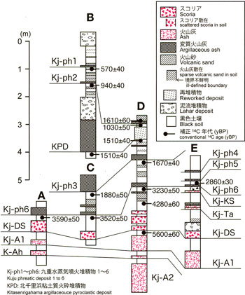
At Kuju Volcano, at least ten phreatic eruptions have occurred since 3.5 ka. Phreatic deposits can be found on the ground surface or in shallow black soil around Iozan (Itoh et al., 2014). There are several numbers of crater-shaped depression, about 100-200 m in diameter, around from Nakadake to Kujuwakare and in the Hosshozan areas. These might be formed by phreatic eruptions.
Six phreatic deposits are distingished in humic soil. Eruption ages for each deposits are estimated by 14C method (![]() Figure 8). Among them, the distribution area is roughly estimated for Kuju Phreatic Deposit 6 (Kj-ph 6) and 3 (Kj-ph 3).
Figure 8). Among them, the distribution area is roughly estimated for Kuju Phreatic Deposit 6 (Kj-ph 6) and 3 (Kj-ph 3).
Kj-ph 6 is distributed in the widest area, where is not only from Kujuwakare to Iozan area but also in the Bougatsuru and Amagaike areas, and on Gakurokuji Lava. In the Kujuwakare area, this deposit is a yellow–white to white clay layer of dozens of centimeters in thickness accompanied by altered-rock fragments. Its 14C age is 3.9–3.5 ka. The eruption source of Kj-ph 6 is estimated as the crater, about 100 m in diameter, near the west of Kujuwakare. This phreatic eruption is associated with clayish lahar. The lahar deposit distributed from the saddle of Kutsukakesan and Kitasenrigahama, and to the southern flank of Nakadake, which are omitted in the geological map. The lahar deposits may be secondary formed from a fall-out tephra (Kj-ph6) which accumulated on the flank. Kj-ph 3 is white–yellow to white clay volcanic ash, and is found from Kitasenrigahama to Iozan area. Its eruption age is 1.8–1.6 ka. In the southeast region of Kitasenrigahama, it is appears on slopes as clayish volcanic ash containing altered rock fragments; thus, its eruption source is assumed to be in southeastern Kitasenrigahama. Phreatic deposits that have eruption ages during historic times are Kj-ph1 and Kj-ph2, those are the 14th to 15th centuries and the 10th to 12th centuries, respectively. Its distribution area has not been determined; thus, the eruption scales for each eruptions are assumed to have been small. In addition, sandy deposits containing altered rock fragments that appear to be a small-scale phreatic deposits are found in some locations around Bougatsuru area. It is difficult to determine the details for these deposits, such as origine, distribution, age and so on.