Asama Volcano
1: Introduction / Geology and petrography of Asama Volcano and environs
2: Quaternary volcanic rocks
3: Pumice flow deposits / Pumice fall accompanied with pumice flow / Pumice and volcanic ash deposits of eastern foot area / Maekake crater
4: Activity of 1108 and Oiwake Pyroclastic Flow / Course of activity
5: Kamayama, the central cone, and recent activities
6: References
![]() PREV
PREV ![]() NEXT
NEXT
4: Activity of 1108 and Oiwake Pyroclastic Flow / Course of activity
Activity of 1108 and Oiwake Pyroclakj
The first product of this activity was coarse-grained brown scoria fall of about 0.4 km3 in volume deposited in the east foot of the volcano.
This was followed by a large quantity of magma from the crater in a short period which flowed down the north and south slopes at high speed as scoriaceous pyroclastic flow spreading and covering about 80 km2 area, the average thickness of which is about 8 m.
This was named Oiwake Pyroclastic Flow. Most of the deposits consist of black scoriaceous blocks and non-welded black volcanic ash, but those distributed on slopes from Yunotaira to Sekisonzan are welded. Terraces on both sides of Agatsuma River, on which Ozasa and Omae villages stand, are made of lightly welded Oiwake Pyroclastic Flow deposits. Immediately after the eruption of Oiwake Pyroclastic Flow, a lava flow followed from summit crater and went down to NW direction. It stopped at 1,500 m a.s.l. and formed Ueno-Butai. The terminus is over 40 m high.
Activity of 1783 ( 3rd year of Tenmei )
Although the scale of activity of Maekakeyama for 1783 is somewhat smaller than that in 1108, as it occurred only 200 years ago, many records are available describing the course of activity in detail.
Course of activity
On May 9th 1783 the first sign of eruption was observed. The crater opened again by the explosion and since then stayed open with smoke rising all the time. On June 25th ash fell with an explosion. On July 17th the volcano erupted with sound and pumice fell on the northern foot area. From July 26th eruption became severe and continued explosive activity intermittently until about August 2nd. The smoke reached high with heavy ash and pumice falls throughout northern Kanto area. On the night of August 2nd, the explosion was particularly violent and people in the southeast foot areas started to flee. On 4th explosions continued without interruption reaching climax in the morning of August 5th. After this the eruption rapidly became quiet and by the evening of 5th peace returned to the crater.
In Karuizawa, a document recorded that ' in the evening of 4th a large explosion started accompanied with falling fireballs. A young man about the age of 24 or 25 was hit by a falling rock and instantly killed. On hearing this people in the village were panic stricken...started to flee everyone for oneself. It was confusion at its extreme. In the chaotic conditions most people fled to Bochi. When the explosion ended on August 5th about 1.2 m thick pumice had fallen in Karuizawa giving an impression of a snow scene. Fifty-two houses out of 162 in Karuizawa were burnt down, and 83 were collapsed by the weight of pumice. In the east and south foot areas people felt fear and confusion by witnessing smoke with lightning and thunder, and falling red hot ejecta' .
In northern foot area, a document recorded that ' on August 4th at about the time of monkey ( about 16:00 ) something suddenly came out of the summit and it spread wide onto an area of two ri ( a ri is unit of length and equal to about 3.7 km ) square' . This should be a description of flowing down scene of Agatsuma Pyroclastic Flow.
' On 5th at 10:00 in the morning a black columnar thing was observed shooting up in the smoke which immediately collapsed in the direction of Kambara wiping four villages, Kambara, Ojuku, Omae, and Hosokubo, in one sweep...' . The sound of explosion was heard at a distance of over 300 km away, and in Edo ( Tokyo ) windows and doors rattled.
The village of Kambara had squarely received this ' extrusion ' resulting in 463 deaths and all the houses were destroyed. Only 93 people escaped deaths. Village of Kambara at that time was situated at about the same place we see it today and to its west was a broad ridge consisting of pumice deposits running NS direction. It is said that people ran up this ridge were saved from death. On the eastern side of the ridge is a small temple of Goddess of Mercy with 15 steps made of stone leading to it. In 1980 this was dug up to reveal that the steps continued further 50 downward, and remains of two victims were found at the lowest step. The ' extrusion ' reached Agatsuma River and temporarily dammed the river at Mihara. Eventually the dam was collapsed to cause terrible flood resulting in 1,377 deaths and about 1,300 houses lost along downstream of Agatsuma River.
Pumice fall deposit
Isopach contour of pumice deposit shows elongated circular shape with axis of elongation lying N17?E except for a narrow branch extending NE direction. The pumice is pale yellowish brown with average density of 0.8, and SiO2 content of 62 %. Phenocrysts include plagioclase, augite, hypersthene, and magnetite.
Top half of the pumice bed is comparatively coarse-grained and homogenous. It is understood to have deposited within a narrow time span of from August 3rd to the morning of 5th. Lower half is comparatively fine-grained and many depositional units are recognized suggesting that this was deposited from intermittent eruptions.
Agatsuma Pyroclastic Flow ( M7 )
Agatsuma Pyroclastic Flow went down in three separate flows from the summit crater in NE to N directions. Central flow was the largest and went down covering a plateau made of Butai Lava Flow. Northeast branch merged with central flow at about 1,450 m a.s.l. and formed a place called Kuromamegawara. The terminus was about 8 km in horizontal distance from the crater. The third branch headed to NNW direction and extended further 2 km northward from the NW edge of Onioshidashi Lava Flow.
The deposit consists of essential scoriaceous blocks and ash matrix of identical material. Central part is mildly welded. Some exposed blocks on the surface are up to 2 m across with characteristic cracks and chilled margins. Those features are similar to bread crust bombs, but blocks are angular and not rounded and the surface of the block is like a cabbage. Within the welded Agatsuma Pyroclastic Flow deposit occur carbonized trees and tree molds. These are identical phenomena seen in lava flows. It was caused by high temperature pyroclastic flow wrapping the tree around and burning off the wood material, and leaving outlines of trees when the flow stopped and welded.
Kambara Pyroclastic Flow/Debris Avalanche ( M8 )
Kambara Pyroclastic Flow/Debris Avalanche was generated accompanying large explosion of August 5th at 10:00. With this explosion half solidified lava which filled the vent was torn and brought up into the air as large blocks. The large blocks fell on the northern slope then mixed with finer materials and came down the slope at high speed like an avalanche. From about 1,300 m a.s.l. the blocks scraped the ground surface and furrowed a groove 800 m wide and up to 40 m deep. This is seen from Asamaen Museum to Prince Land. About 8 km away from the crater the flow lost kinetic energy rapidly and most of the large blocks stopped there. However, a great amount of dug up materials continued to flow down toward north reaching Agatsumagawa Gorge. This debris flow was the material which destroyed villages of Kambara, Omae, Ozasa etc.
Thickness of Kambara Debris Flow is 2 to 3 m in average. Most of it is from materials of old ground surface, that is, a mixture of fragments of pre-existing pyroclastic flow and pumice flow deposits etc. On the other hand, large blocks often seen on the upper slope are high temperature essential materials with characteristic shape and structure like bread crust bomb.
Onioshidashi Lava Flow ( M10 )
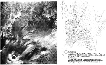
Onioshidashi Lava Flow extends about 5.5 km in horizontal distance from the summit crater to the north and occupies an area of 6.8 km2. Its upper part is buried under the recent ejecta of ash and lapilli, but lower part retains fresh rugged appearance showing a good contrast from the surrounding area. In the upper and middle parts natural levee is retained. The surface topography of Onioshidashi Lava is classified into three ( ![]() Fig.4 ).
Fig.4 ).