Asama Volcano
1: Introduction / Geology and petrography of Asama Volcano and environs
2: Quaternary volcanic rocks
3: Pumice flow deposits / Pumice fall accompanied with pumice flow / Pumice and volcanic ash deposits of eastern foot area / Maekake crater
4: Activity of 1108 and Oiwake Pyroclastic Flow / Course of activity
5: Kamayama, the central cone, and recent activities
6: References
![]() PREV
PREV ![]() NEXT
NEXT
2: Quaternary volcanic rocks
Ejecta of Hanamagari Volcano ( Hn )
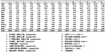
Andesitic volcanic rocks developed in a boundary area between Nagano and Gumma Prefectures NE of Karuizawa are collectively named ejecta of Hanamagari Volcano. Lava flow near Metaki Waterfall east of Ichinojiyama shows normal magnetization with K-Ar age of 1 x 10⁶ yBP. The rocks are mostly phenocryst-rich augite-hypersthene andesite.
Asama Bokujo Andesitic Rocks ( Ab )
Flat plateau of Asama Bokujo north of upper reach of Yukawa River ( the valley of Shiraito Waterfall ) seems to represent an independent volcano and thus named Asama Bokujo andesitic rocks. The eruptive center of the rocks is estimated to be at prefectural boundary area north of Shiraito Waterfall. Mostly the rocks are essential tuff breccia ( augite-hypersthene andesite or dacite ). Also a small Shiraito Pyroclastic Flow deposit is contained in them.
Takatsuyama Andesitic Rocks ( Tk )
Takatsuyama Andesitic Rocks develop to the south of the valley of Shiraito Waterfall. They form flat plateau consisting of alternated augite-hypersthene andesitic tuff breccia and lava flow. Part of lava flow is exposed in the valley of Sengataki.
Nishi-Sengataki Andesitic Rocks ( Ns )
These are lithologically similar to rocks of Asama Bokujo and Takatsuyama andesites. Intercalated tuff breccia and lava flow are exposed in Nishi-Sengataku area forming a plateau. The structure is obscure.
Eboshi Volcano ( Eb )
This is a complex volcano forming a ridge on the west side of Asama Volcano and consisting of several stratovolcanoes and lava domes. The volcanic bodies are partially overlapping with the eastern volcano which is probably the youngest. The rocks forming Kagonoto and Takamine summits of stratovolcanoes are intercalation of augite-hypersthene andesitic lava flows and pyroclastic materials.
Kusatsu-Shirane Pyroclastic Flow Deposits( Ks )
These are thick pyroclastic flow deposits from Kusatsu-Shirane Volcano and develop in the foot area to the north of Asama Volcano. They form gorges with continuous cliffs of several tens of meters high along Agatsuma and Manza Rivers. The deposits vary from non-welded to somewhat welded showing coarse columnar joints. Essential blocks in them are grayish white augite-hypersthene dacite which is flattened to form parallel lenses where welding is advanced.
Mihara Formation ( Mi )
Immediately south of present-day Agatsuma River was a wide and shallow depression extending EW. Alluvial and lacustrine deposits named Mihara Formation filled this depression. The thickness is up to 50 m consisting of complex intercalation of river-bed gravel, sand, and clay in addition to mud flow deposits, all showing remarkably changeable lithofacies when traced sideways.
Hanareyama Lava Dome ( Ha ) and Kumoba Pyroclastic Flow Deposit ( Kpf )
Hanareyama standing in between Karuizawa and Naka-Karuizawa is a lava dome consisting of biotite-augite-hornblende-hypersthene dacite. On both east and west sides of the lava dome are found short but thick lava flows giving stretched appearance in EW direction to Hanareyama. Kumoba pyroclastic flow deposit characteristically containing biotite seems to have erupted from the same crater as Hanareyama.
Landform of Asama Volcano and its constitution
Highest point of Asama Volcano is at the NE edge of Kamayama crater at 2,560 m a.s.l. Trig point is located at 2,450.6 m of Maekakeyama. In the west of Asama Volcano is Mt. Kurofuyama which is a remnant of old crater of 1.5 km across opening to the east. The floor of this crater is called Yunotaira. Immediately to the east of Yunotaira is Maekakeyama having double craters. The outer crater is 1,100 m EW and NS 900 m across. Its west edge is Maekakeyama while the east edge Higashi-Maekakeyama. The inner crater is called Kamayama 350 m across, and is active. The inner Kamayama crater is 300m in diameter with a 200 m vertical drop.
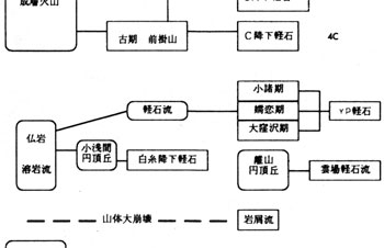
The Asama Volcano consists of four volcanic bodies as shown in ![]() Fig. 1.The oldest is Kurofuyama estimated to be several tens of thousand years old. Hotokeiwa Lava Flow followed Kurofuyama and main volcanic body was formed. At the same time of this or immediately afterward, large scale pumice flow eruption occurred, the deposits of which spread in north and south of the volcano. This is the second stage activity. The third stage activity is the eruption of Maekakeyama which became active several thousand years ago and still continues to be active.
Fig. 1.The oldest is Kurofuyama estimated to be several tens of thousand years old. Hotokeiwa Lava Flow followed Kurofuyama and main volcanic body was formed. At the same time of this or immediately afterward, large scale pumice flow eruption occurred, the deposits of which spread in north and south of the volcano. This is the second stage activity. The third stage activity is the eruption of Maekakeyama which became active several thousand years ago and still continues to be active.
Kurofuyama ( early stratovolcano )
Kurofuyama is a stratovolcano similar to Mt. Fuji. It has simple structure with a single crater in the center. Slopes of Kurofuyama are well developed in both north and south sides dissected by many valleys, but most of original topography is well preserved. The position of central crater is estimated to be at the center of the Yunotaira crater floor and near the terminus of a new lava flow from Maekakeyama. Estimated height at the time of culmination of activity is 2,800 to 2,900 m a.s.l. on the assumption that the summit crater diameter was 500 m across.
Kurofuyama mainly consists of olivine-bearing augite-hypersthene andesite lava and pyroclastic materials, but based on the types of rocks and structural unconformities , it is classified into the following three groups.
Gippa Group ( Kl )
Materials erupted from Kurofuyama Stratovolcano at the earliest stage ( mainly pyroclastic ejects and lava ) are most abundant among three groups and lithologically least varied. Gippa Group, which occupies center of the volcano, consists of welded essential tuff breccia and small amount of agglomerate and comparatively thin lava flow. As a whole it is well welded and resistant to erosion and forms characteristic spires.
Mitsuone Group ( K2 )
Mitsuone Group overlies Gippa Group without noticeable unconformity. As it covers most of the mountain flanks, its distribution on the geologic map is widespread. However, its thickness is small occupying only 1/3 of the volume of Kurofuyama Stratovolcano. Most lavas belonging to this group are characterized by olivine phenocrysts.
Sennin Group ( K3 )
Lava flows belonging to Sennin Group show restricted distribution within the northern slope of Sennin-iwa. They are clearly more silicic than Gippa and Mitsuone Group rocks, and at the time of eruption, flow seemed to be more viscous. Groundmass is very fine-grained and concentrated patches of xenoliths and xenocrysts are locally developed.
Pumice fall and volcanic ash deposits of Kurofuyama
Stratigraphically lowest pumice fall bed deposited in the eastern foot areas of Asama Volcano is lithologically identified as one of the late ejecta of Kurofuyama Stratovolcano. Itahana Brown Pumice bed (often abbreviated as BP ), consisting of dark brown parti-colored pumice and abundant lithic fragments, and occurring below the 'Jobu ( upper ) Loam' distributed in the NW of Kanto region, is correlated to pumice fall deposit of upper Kurofuyama sequence.
Sekisonzan Lava Dome ( S )
Sekisonzan situated on southern middle flank of Maekakeyama is a lava dome with 250 m relative height. The lava is silicic andesite with phenocrysts of mainly plagioclase, hypersthene, augite, and opaque mineral. In the groundmass, abundant tridymite and quartz occur.
Collapse of eastern half of Kurofuyama and debris avalanches ( Tsukahara Debris Avalanche, K4; Shiozawa Debris Avalanche, Sd; and Okuwa Debris Avalanche, Ok )
West of Komoro in the south of Iwamurada on the right bank of Chikumagawa River, about 10 km2 area is occupied by several tens of characteristic small hills ( Nagareyama ) ( several to ten something m high ). These are debris avalanche deposits resulted from collapse of eastern Kurofuyama. The deposits are similar to debris avalanche deposits of Bandaisan in 1888 and Mt. St Helens in 1980. The deposits covered wide areas of eastern foot of Asama Volcano. Those distributed in Tsukahara is called Tsukahara Debris Avalanche deposit while distributed in Minami-Karuizawa is Shiozawa Debris Avalanche deposit. Okuwa Debris Avalanche deposit distributed in the northern foot area is also a product from collapse of Kurofuyama and shows similar lithology. Large scale mud flow ( Maebashi Mud Flow ) was triggered by damming of Agatsuma and upper reach of Tone Rivers with this debris avalanche. The deposits of the Maebashi Mud Flow are clearly visible in many places even today.
Because of this large scale collapse of Kurofuyama, cliff running from Sennin-iwa at NE edge of the crater toward NE direction, and another cliff running from Kengamine at SE edge of crater wall toward SE direction were formed. On the surface of these two cliffs are exposed interbedded lava flows and pyroclastic materials showing cross section of stratovolcano well.
Hotokeiwa Lava Flow ( Hl )
Hidden under the Maekakeyama ejecta on the SE slope of Maekakeyama is fan-shaped S, SE, and E sloping quarter cone of a volcanic body, the highest exposure of which is at about 2,200 m. This is almost entirely consisting of thick silicic( SiO2=70-74 % ) dacite lava with little pyroclastic materials. Ko-Asamayama is also consisting of similar dacite. Collectively we call these Hotokeiwa lavas.
All the Hotokeiwa lavas characteristically have common hornblende and strongly magnetic titanomagnetite as phenocrysts. The groundmass is variable in parts. Chilled margin is glassy but away from it the center of lava is holocrystalline consisting of plagioclase, augite, hypersthene, and opaque mineral with additional alkali feldspar, tridymite, and quartz.
On the southern middle flank of Maekakeyama are cliff lines in two steps in NS direction. Those are thick lava flows of Hotokeiwa and Midagashiroiwa exposed along a fault. Large scale columnar joints and flowage structure are well developed. Top and bottom of lava flows show glassy groundmass while middle parts are lithic and grayish white.
Ko-Asama Lava Dome ( H2 )
Ko-Asamayama consists of dacite, the lithologic character of which closely resembles to that of Hotokeiwa lava. It is a lava dome about 200 m high. In the middle of the dome is a NS trending fault by which western half seems to be downthrown a little. Near Shiraitonotaki Waterfall to the east of Ko-Asamayama is distributed white pumice fall deposit with maximum thickness of 30 m ( Shiraito Pumice Fall ). This is interpreted to have erupted from the same crater of Ko-Asamayama at the earliest stage of activity.