Asama Volcano
1: Introduction / Geology and petrography of Asama Volcano and environs
2: Quaternary volcanic rocks
3: Pumice flow deposits / Pumice fall accompanied with pumice flow / Pumice and volcanic ash deposits of eastern foot area / Maekake crater
4: Activity of 1108 and Oiwake Pyroclastic Flow / Course of activity
5: Kamayama, the central cone, and recent activities
6: References
![]() PREV
PREV ![]() NEXT
NEXT
3: Pumice flow deposits / Pumice fall accompanied with pumice flow / Pumice and volcanic ash deposits of eastern foot area / Maekake crater
Pumice flow deposits
Okubozawa and Tsumagoi Pumice Flow Deposits ( P1, P2 )
These pumice flow seems to have originated from the same crater at the same time of Hotokeiwa Lava Flow and Ko-Asamayama Lava Dome along with other pumice falls. An example is a small pumice flow deposit at SE foot of Hotokeiwa Volcano with comparatively high SiO2 ( Okubozawa Pumice Flow deposit, P1 ). In the northern foot areas of Asamayama, scattered occurrences of pumice flow deposits exist with different bulk rock composition to either Okubozawa Pumice Flow or Komoro Pumice Flow ( described later ). This is called Tsumagoi Pumice Flow deposit ( P2 ). The crater from which this was erupted is not clear, but seems to be from the same crater of Hotokeiwa Lava Flow or some other close crater.
Komoro Pumice Flow Deposit ( P3, P4 )
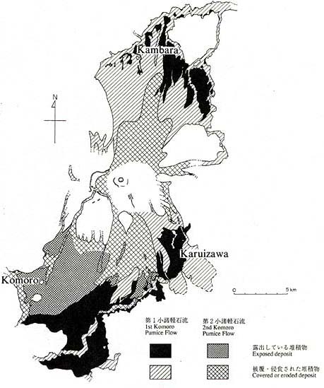
On the other hand, at both foot areas of south and north of Asamayama, voluminous pumice flow deposits are distributed. Those seem to have erupted considerably later than the activity of Hotokeiwa Lava Flow. Collectively those are called Komoro Pumice Flow deposit. As shown in the geologic map it is divided into two, First and Second Pumice Flows. The C-14 ages from carbonized wood chips contained in the deposits gave about 14,000 and 11,000 yBP, respectively. Immediately above the First Pumice Flow deposit is black weathered soil up to 20 m thick. The distribution of the First and Second pumice flows is shown in ![]() Fig.2. It is clear from the map that those flowed down faithfully along the topographic low. As traced back to the crater, the deposits become thinner and finally disappear. The gradient at which large scale deposition commenced is about 6?.
Fig.2. It is clear from the map that those flowed down faithfully along the topographic low. As traced back to the crater, the deposits become thinner and finally disappear. The gradient at which large scale deposition commenced is about 6?.
The First Komoro Pumice Flow deposit ( P3 ) is about three times as voluminous as the Second Komoro Pumice Flow. It covers much wider area too. The crater was located at near current crater of Maekakeyama. At that time Kurofuyama was in the west and another volcano, from which Hotokeiwa Lava Flow was originated, is in the east. The depression between the two volcanoes was open to both north and south. Erupted voluminous ash and pumice flowed to both north and south and formed gentle slopes at the foot areas. The flow went to the south filled the Yukawa River valley and formed dammed lake, while the one flowed north filled Agatsumagawa River valley. Small part of erupted ash and pumice went down the Jaborigawa River crossing Kurofu crater. Very small amount of ejecta went over Kurofu crater rim and over Hotokeiwa Volcano.
In general, no distinct unconformity exists between Second Komoro Pumice Flow deposit ( P4 ) and underlying First Komoro Pumice Flow deposit. In many outcrops, intervening soil was scraped off and it is difficult to tell which is which. However, between old Komoro Castle and Komoro Power Station, notable unconformity is exposed suggesting that enough time was available for the formation of over 30 m deep valley between eruptions of two pumice flows.
Minami-Karuizawa Lake Deposit and Saku Lake Deposit ( L )
Yukawa River was once dammed by First Komoro Pumice Flow and a shallow temporary lake was formed filling part of flat area in Minami-Karuizawa, southeast of the volcano. Lake deposits consisting of pumiceous clay and fine-grained sand with development of fine lamination are well developed with the thickness up to 15 m. In Saku Basin similar beds are here and there developed suggesting that Chikumagawa and Yukawa Rivers were temporarily dammed.
Pumice fall accompanied with pumice flow
Among ash and pumice beds distributed in NW of Kanto Plain area, those correlated to activities of Asama Volcano is Itahana Yellow Pumice ( abbreviated as YP ). This corresponds to the pumice and ash deposits erupted at the same time of Saku and Hirahara Pumice Flow. It consists of many members and one of the major members is distributed widely with its depositional axis in NE direction extending from Asama Volcano. It is called Tsumagoi Pumice Fall immediately overlying Tsumagoi Pumice Flow deposit with thickness of 100 to 150 cm in NE foot of Asama Volcano.
From Takatsuyama, Asama Bokujo, and Sengataki to Minami-Karuizawa, many characteristic multicolored finely bedded volcanic ash outcrops are distributed. In Sengataki area the thickness is up to several m, in the eastern Minami-Karuizawa 2-3 m, and the distribution is traced to areas of northern Gumma Prefecture. This characteristic ash bed of fine lamination is interpreted to be a result of repeated small scale eruptions of ash after the main pumice flow eruption.
Maekakeyama ( late stratovolcano )
Growth of Maekakeyama
After the eruption of pumice flow and collapse of surrounding area of the crater, Asama Volcano became dormant for some time. Then Maekakeyama was born. The eruptive center was 2 km to the east of central crater of Kurofuyama stratovolcano. Augite-hypersthene andesite ( SiO2=60-63% ) was repeatedly ejected as pyroclastic materials and as lavas to rapidly form Maekakeyama, a conical stratovolcano. Maekakeyama today is 2,560 m a.s.l., highest in Asama Volcano, but its relative height from saddle is only 1,200 m.
Pumice and volcanic ash deposits of eastern foot area
Pumice fall and ash deposits from Maekakeyama are distributed widely in the eastern foot of Asama Volcano. These unconformably overlie pumice and ash beds of Hotokeiwa stage and distributed parallel to the present day ground surface. About 10 individual pumice beds are recognized and the topmost bed ( called Bed A ) is the product of 1783 ( 3rd year of Tenmei ) eruption. The pumice and scoria bed, Bed B, immediately underlying the Bed A is estimated to be the product of 1108 ( 1st year of Tennin ) eruption. Therefore, those two pumice and scoria beds, A and B, have deposited within last 880 years. Total thickness of beds A and B corresponds to one severalth of total thickness of ejecta in Maekakeyama stage. This indicates that the age of Maekakeyama is fairly young to be only several thousand years old. Total volume of Maekakeyama ejecta is estimated to be about 3 km3 which is roughly equal to the whole Maekakeyama stratovolcano. As compared with early stratovolcano, Kurofuyama, the ratio of pyroclastic materials in Maekakeyama stratovolcano is far higher.
Maekake crater
The summit crater of present day Maekakeyama has double ring structure. The outer crater is 1,300 m EW and 900 m NS in diameter. This crater seems to have formed by collapse after the eruption of Oiwake Pyroclastic Flow during 1108 activity. Crater wall is well developed in the west, but no steep wall exists in the east except for a small hill ( Higashi-Maekakeyama 2,463 m ) in the SE side. Central cone, Kamayama ( relative height 170 m ), is located within the above crater at slightly northerly position and filled most of Maekakeyama crater leaving only shallow depressions in the east, south, and west sides. Two sheets of solid rock with well developed columnar joints in the middle of western crater wall ( Byobuiwa ) would easily be mistaken as lava flows but actually are welded pyroclastic rocks ( tuff breccia ).
Kotaki Pyroclastic Flow ( M2 )
In west of Butai, a slope east of Onioshidashi Lava Flow, and in a cliff SE of Butai is exposed comparatively old pyroclastic flow deposit. Collectively this is called Kotaki Pyroclastic Flow. The matrix shows characteristic reddish brown oxidation.