Usu Volcano - 2nd Edition -
Introduction to the 1st edition (1981) / 1 : Geology of Usu Volcano and environments / 2 : Outline of Usu Volcano
3 : Eruptions of historical times Characteristics of the eruptions of historical times
4 : Rocks of Usu Volcano
5 : Surveillance and observation of activities / 6 : Prediction of future activities and mitigation of damage
References / Note
![]() PREV
PREV ![]() NEXT
NEXT
5: Surveillance and observation of activities / 6: Prediction of future activities and mitigation of damage
5: Surveillance and observation of activities
For the 1910 eruption of Usu Volcano, earthquakes were recorded by temporarily installed seismograph and crustal movements were checked with leveling. These observations by Fusakichi Omori were the forerunner of modern volcanic studies in Japan. For the formation of Showa Shinzan during 1943-45, seismic studies, crustal deformations, topographic changes, and geomagnetic and geothermal observations were carried out. Furthermore, newly erupted lava, volcanic gas, and sublimation deposit were studied in detail, by which characteristic features of viscous dacitic magma became clear. Following the above, multifaceted observations by various institutions including universities, Meteorological Agency, and Geological Survey of Japan became a norm. Especially during the 1977 - 78 and the 2000 eruptions, the Coordinating Committee for Prediction of Volcanic Eruptions organized an on-site study team to coordinate the observations and interpretations of the results, and provided information to local disaster countermeasure offices. Also in 1977, Usu Volcanological Observatory ( UVO ) was established by Hokkaido University. Combined with similar observatories, Usu became one of the most intensively monitored volcanoes in Japan.
At the moment, UVO, JMA, GSI, and other institutions have conducted seismic observations and continuous or repeated observations of crustal deformation with GPS, tiltmeter, extensometer, and leveling, as well as observations for gravity, geomagnetism, terrestrial current, ground temperature, fumarole temperature, groundwater level and others. Other research institutions including universities and individual researchers have been studying ejecta including pumice and ash, volcanic gas, and spring water.
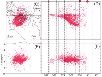
![]() Fig. 9 shows the seismic activities and crustal movements of the 2000 eruption. On March 27th, baseline lengths of GPS started to extend and it indicated the expansion of underground magma at 10 km deep. At the same time, seismic activity started several km below ground, and the seismic center started ascending gradually ((I) of stage I). On the evening of March 28th, ascending of seismic center slowed down and the source region started to expand horizontally ((II) of stage I). On the afternoon of March 29th, the expansion of underground area ( 10 km deep ) changed to contraction and the seismic activities reached a climax ((III) of stage 1 ). And finally, eruption started at 1:07 p.m. on March 31st. These observations are interpreted together with experimental petrological data as follows; ( 1 ) On March 27th, inner pressure of the lower magma chamber ( 10 km deep ) increased and magma ascended into the upper magma chamber ( 5-6 km deep ). ( 2 ) After March 29th, the lower magma chamber started to contract. On the other hand, the magma kept ascending from the upper magma chamber and partially intruded horizontally ( sill formation ). ( 3 ) Magma eruption started on March 31st.
Fig. 9 shows the seismic activities and crustal movements of the 2000 eruption. On March 27th, baseline lengths of GPS started to extend and it indicated the expansion of underground magma at 10 km deep. At the same time, seismic activity started several km below ground, and the seismic center started ascending gradually ((I) of stage I). On the evening of March 28th, ascending of seismic center slowed down and the source region started to expand horizontally ((II) of stage I). On the afternoon of March 29th, the expansion of underground area ( 10 km deep ) changed to contraction and the seismic activities reached a climax ((III) of stage 1 ). And finally, eruption started at 1:07 p.m. on March 31st. These observations are interpreted together with experimental petrological data as follows; ( 1 ) On March 27th, inner pressure of the lower magma chamber ( 10 km deep ) increased and magma ascended into the upper magma chamber ( 5-6 km deep ). ( 2 ) After March 29th, the lower magma chamber started to contract. On the other hand, the magma kept ascending from the upper magma chamber and partially intruded horizontally ( sill formation ). ( 3 ) Magma eruption started on March 31st.
6: Prediction of future activities and mitigation of damage
Usu Volcano has activities repeated in every 30 - 50 years. This repeating pattern seems to be important in predicting activities. Furthermore, the eruptions were invariably preceded by earthquakes. This seems to be due to high viscosity of silicic magma. In the 2000 eruption, prediction of the eruption and advance evacuation of residents were successfully carried out, thanks to observation and analysis of various precursory phenomena.
From the history and structure of the volcano, future activity would occur in an NW-SE elongated area including the summit itself as well as in northern foot area. In those areas destructive crustal movements were seen accompanying the formations of Meiji-shinzan, Showa-shinzan, and eruptions in 1977 - 78 and 2000. The area corresponds to inside of south wall of Toya caldera, where the ground is not very firm providing conduit to magma and susceptible to crustal deformation.
The mode of eruption is determined essentially from the nature of magma. The composition of magma in historical times is silicic ( high in SiO2 ) slightly decreasing with time. However, it is hard to imagine that changes of the compositions would take place in the coming decades. Therefore, dacitic eruptions would continue for foreseeable future. The most likely mode of eruption then is explosive activity with abundant pumice and ash. Pyroclastic flow may occur as were seen in the past three eruptions ( ![]() Fig. 10 ). Also with the uplift of viscous magma, cryptodome or lava dome may be formed with much crustal deformation. If the eruption occurs in the north foot area close to Lake Toya, like 1910 and 2000, explosive phreatic eruptions resulting from contacting of abundant groundwater and magma may happen, or volcanic lahar flowing out directly from the crater can not be ruled out.
Fig. 10 ). Also with the uplift of viscous magma, cryptodome or lava dome may be formed with much crustal deformation. If the eruption occurs in the north foot area close to Lake Toya, like 1910 and 2000, explosive phreatic eruptions resulting from contacting of abundant groundwater and magma may happen, or volcanic lahar flowing out directly from the crater can not be ruled out.
In general, eruption vents tend to be located elsewhere than pre-existing domes. However, many domes are already closely located on the summit. Thus, frequency of eruption at the foot of mountain may be increase. On the other hand, we should consider the possibility of summit eruption accompanied by sector collapse ( ![]() Fig. 10 ).
Fig. 10 ).
On the basis of predicted eruption mode mentioned above, the contributing factors of hazard may include pyroclastic flow, lahar, and, although the possibility is very low, sector collapse, in addition to pyroclastic fall and crustal deformation. The area affected may be variable depending on individual cases; damage from pumice and ash fall would cover wide areas but very much dependent on wind direction. On the other hand those from volcanic blocks and bombs are restricted within 2.0 to 2.5 km from the crater. Predicted destructive crustal deformation would occur in the northern foot area. Pyroclastic flow would be most destructive and may reach 5 to 6 km from the summit referring to the past examples. The area lahar may hit is controlled by the position of crater, topography and drainage pattern of the area.
In addition, not directly related to eruption though, mud flow accompanied with heavy rain may occur like it happened in 1977-78. Collapse of volcanic body seen in NE and part of SE of somma would continue in the future. Some measures to prevent damage from this source seem to be necessary.