Usu Volcano - 2nd Edition -
Introduction to the 1st edition (1981) / 1: Geology of Usu Volcano and environments / 2: Outline of Usu Volcano
3: Eruptions of historical times Characteristics of the eruptions of historical times
4: Rocks of Usu Volcano
5: Surveillance and observation of activities / 6: Prediction of future activities and mitigation of damage
References / Note
![]() PREV
PREV ![]() NEXT
NEXT
 ZOOM
ZOOM 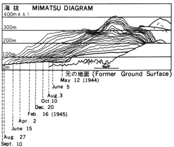 ZOOM
ZOOM 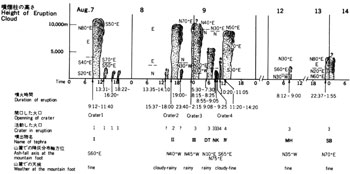 ZOOM
ZOOM 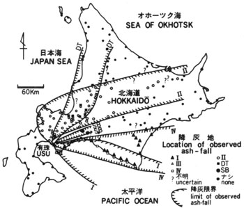
 ZOOM
ZOOM 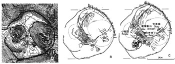 ZOOM
ZOOM  ZOOM
ZOOM 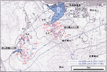
3: Eruptions of historical times Characteristics of the eruptions of historical times
Despite short development history of Hokkaido, the eruptive record of Usu Volcano is well documented and the record is geologically well correlated with distribution of tephra ( volcanic ejecta such as ash) around the volcano ( ![]() Fig. 1 ). According to the record, Usu Volcano has erupted eight times since 1663 ( the 3rd year of Kanbun ) (
Fig. 1 ). According to the record, Usu Volcano has erupted eight times since 1663 ( the 3rd year of Kanbun ) ( ![]() Table 1 ). All of them were by the activities of silicic magma and pumice and ash were ejected accompanying formation of domes. Pyroclastic surge ( 1663 ), pyroclastic flows ( 1769, 1822, and 1853 ), and volcanic mud flow spilled directly from the vent ( 1910, 2000) also occurred. Pyroclastic flows contain much poorly vesiculated pumice and flowed down in all directions. In general duration of eruption is short ( a month to 2 years ) and dormancy is long ( about 30 to 50 years ). The volcanic activities have been triggered by viscous dacitic magma, and characterized by accompaniment of many earthquakes and significant crustal change. Five eruptions ( 1663, 1769, 1822, 1853 and 1977 - 78 ) out of eight were summit eruptions, and those were accompanied by pumice eruptions (plinian or sub-plinian eruption) in initial stage. On the other hand, eruptions occurred in 1910, 1943 - 45 and 2000 were flank eruptions from the northeastern or northwestern foot, not pumice eruptions, and those were accompanied by phreatic or phreatomagmatic eruptions in initial stage. These eruptions are classified into 4 groups as described below: type 1663,type 1769/1822/1853/1977, type 1910/2000 and type 1943.
Table 1 ). All of them were by the activities of silicic magma and pumice and ash were ejected accompanying formation of domes. Pyroclastic surge ( 1663 ), pyroclastic flows ( 1769, 1822, and 1853 ), and volcanic mud flow spilled directly from the vent ( 1910, 2000) also occurred. Pyroclastic flows contain much poorly vesiculated pumice and flowed down in all directions. In general duration of eruption is short ( a month to 2 years ) and dormancy is long ( about 30 to 50 years ). The volcanic activities have been triggered by viscous dacitic magma, and characterized by accompaniment of many earthquakes and significant crustal change. Five eruptions ( 1663, 1769, 1822, 1853 and 1977 - 78 ) out of eight were summit eruptions, and those were accompanied by pumice eruptions (plinian or sub-plinian eruption) in initial stage. On the other hand, eruptions occurred in 1910, 1943 - 45 and 2000 were flank eruptions from the northeastern or northwestern foot, not pumice eruptions, and those were accompanied by phreatic or phreatomagmatic eruptions in initial stage. These eruptions are classified into 4 groups as described below: type 1663,type 1769/1822/1853/1977, type 1910/2000 and type 1943.
Eruption of 1663 ( the 3rd year of Kanbun )
From August 13th ( July 11th of the old lunar calendar ), many earthquakes were experienced. On 16th, eruption started and from 17th, earthquake and eruption became intense accompanying thunder. Ash fall intensity increased and up to about 5 km from the shoreline the SW sea was said to have been like reclaimed by ash fall. Smoke column was visible from Tsugaru, Honshu, and air vibration was felt even in Shonai region. Many houses were buried and burnt with five people killed. The eruption continued till the end of August.
During this activity up to 2.5 km3 rhyolitic pumice fall ( Us-b Bed ) deposited in the east reaching about 1 m thick in Shiraoi coast. Eruption of pumice was followed by volcanic block and ash ejections and several pyroclastic surges. The thickness of the deposit ( Us-b1-b6 Beds ) resulting from the activities is estimated to be 1-3 m at the foot and several tens of meters on the flank of the mountain. Large and small blocks are found mixed in the deposit. Although it was not documented, at the end of this activity or activity of 1769 described later, Kousu Lava Dome ( Fushikonupuri; meaning old hill in Ainu language ) was inferred to have formed. Kousu Lava Dome is, however, presumably the product of the 1769 eruption because its petrological characteristics are similar to those of 1769 tephra, but not similar to 1663 tephra.
Pre-Meiwa Eruption
It was proposed that little eruption occurred in late 17th century ( but not documented ). A 17 cm thick layer composed of pumice fall deposit, volcanic ash and pyroclastic surge deposits was found during the trench excavation survey in the northwestern foot ( Nakagawa et al., 2005 ). The detail of this eruption is still unknown.
Eruption of 1769 ( the 5th year of Meiwa )
On January 23rd ( December 16th of the old lunar calendar ), eruption started. It was said that in the later stage of this activity 'fire fell everywhere' and all houses of SE foot area were burnt down. Before the eruption earthquakes were felt according to old record. Pyroclastic fall deposit ( Us-Va Bed ) consisting of pumice and ash reached 30 to 50 cm thick. The fire was a result of pyroclastic flow ( Meiwa Pyroclastic Flow ) which followed pumice and ash fall. The flow was distributed in not only SE side but also SW and N sides along valleys and contained abundant poorly vesiculated pumice. As was mentioned before, the formation of Kousu Lava Dome probably occurred at the end of this eruption. In the 2nd edition, Kousu Lava Dome is treated as the 1769 eruptive product.
Eruption of 1822 ( the 5th year of Bunsei )
Earthquakes were felt from March 9th ( intercalary January 16th of the old lunar calendar ) and increased intensity with time. Eruption started to occur from 12th. The intensity increased and on 15th a pyroclastic flow reached to the foot of the mountain. The eruption continued and on 23rd the largest pyroclastic flow came down the mountain. Mountain foot areas from SE to W, all the trees were burnt down. Village of Abuta ( now Irie ) was burnt out with 82 people dead, and 1437 horses dead. The flow is called Bunsei Pyroclastic Flow. The eruption continued at least 4 months.
The pyroclastic fall deposits of 1822 ( Us-IVa Beds ) consist of many fall units and their thickness in the western foot is 30 cm while in the east it is nearly 1 m. The pyroclastic flow deposits consist of 2 flow units matching with record of eruption and distributed widely in southern foot area. They are also distributed in north and eastern foot areas along valleys. The thickness is 1 to 3 m, but in places it reaches 6-7 m. According to a drilling data in crater floor the pyroclastic flow deposits are 20 - 42 m thick. The deposits are poorly sorted ash with grayish white to reddish grey-white colored with abundant poorly vesiculated pumice mixed with bread crust bombs and carbonized woods. At the end of Bunsei activity a cryptodome called Ogariyama seems to have formed. However, recognition of Ogariyama ( meaning growing mountain ) as cryptodome had to wait until Meiji era (about 1890). Cross section of Ogariyama became visible by an E-W running fault related to 1977-78 eruption by which northern half was uplifted exposing lavas and pyroclastic rocks within the dome.
Eruption of 1853 ( the 6th year of Kaei )
From April 12th ( March 5th of the old lunar calendar ), earthquakes started and rumblings were heard. They became intense and an eruption began from the eastern summit on 22nd. On 29th the eruption became more intense until May 4th. On May 5th while earthquakes continued, Ousu Lava Dome ( Ashirinupuri; meaning new mountain in Ainu language ) appeared. White smoke was seen to rise from the dome even after two years. Pumice and ash fall deposits of 1853 ( Us-IIIa bed) is 30 cm thick in the west and 50 to 100 cm in the eastern foot. In the eastern flank to foot areas pumice and ash fall bed is overlain by poorly sorted pumice and ash of 2 to 3 m thick. This is pyroclastic flow deposit occurred towards the end of activity called Kaei Pyroclastic Flow or Tateiwa Pyroclastic Flow and contains abundant carbonized tree fragments. Ousu Lava Dome formed at the end of 1853 activity seems to have continued to grow and its height was determined to be 595 m in 1889, 692 m in 1905, 700 m in 1909, and 740 m in 1911. A cryptodome on the SE side of Ousu also seems to have formed with the activity of 1853.
Eruption of 1910 ( the 43rd year of Meiji )
Many earthquakes occurred from July 21st and increased intensity. On the night of 25th when the intensity was a little abated, eruption started near Kompira Yama at the northern foot. Eruptions continued intermittently, forming many explosion craters aligned in WNW-ESE zone for 2.7 km. The number of the craters was 15 until August 2nd and increased by 45 until November. The smoke reached maximum of about 700 m and clay-rich ash fell around crater ( Us-IIa Bed ). Volcanic blocks fell within 300 m of the crater. The eruptions were all phreatic and no new magma-derived material was ejected. High-temperature volcanic mud flow ( hot mud flow ) flowed out directly from six craters. The maximum speed of the mudflow was 40 km/hour resulting in one death. Since August, crustal movement continued on the north foot of the Usu Volcano and normal faults were formed to the north of aligned craters with the uplift of about 155 m by November 11th. The newly formed hills are called Meiji-shinzan ( Yosomiyama ). The intermediate area between Meiji-shinzan and Higashi-maruyama was lifted by about 75 m. Those are all due to cryptodome activity. Volcanic activity had stopped by August 5th of the next year. The activity of 1910 was interpreted to be intense phreatic eruption by contact of magma with rich groundwater in the northern foot area, followed by formation of cryptodomes by further ascent of the magma in the underground. Immediately afterwards, discharge of hot spring on the shore of Lake Toya started.
Eruption of 1943 - 45 ( the 18th to 20th year of Showa )
At the end of 1943, frequent volcanic tremors had commenced. This volcanic activity continued until September 1945 during which time Showa-shinzan was formed in the eastern foot. This activity is divided into the following three stages.
( i ) Pre-eruption stage ( December 28th 1943 to June 22nd 1944 ):On December 28th 1943 earthquake was felt in all Usu Volcano area. Nearly 20 earthquakes were felt per day in the northern foot area. In 1944 the number of earthquakes decreased but earthquake foci became concentrated to the underground of eastern foot. In Yanagihara of the eastern foot area the land was uplifted the amount of which reaching 16 m by April causing various damages. From middle April the center of upheaval shifted to Fukaba village ( now the eastern side of Showa-shinzan ) to the north with the maximum uplift of 50 m. The intensity of earthquake increased and the number of felt earthquakes reached 250 times on June 22nd alone.
( ii ) Explosive stage ( June 23rd 1944 to October 31st 1944 ):On June 23rd a phreatic explosion commenced in a cultivated field of Higashi-kumantsubo ( now the central part of Showa-shinzan ), west of Fukaba. The intensity increased from July 2nd and more than 10 powerful explosions occurred by the end of October. Especially the explosions of July 2nd and 3rd were very powerful and ash fall was recorded in distant Tomakomai and Chitose to the east. On July 11th, low-temperature ( 60 - 70?C ) pyroclastic surge blew down the conservation forest and cabins. These explosions produced ash fall ( Us-Ia Bed ) and its total thickness was several cm at places 1 km away. The color of ash was grey and mostly of comminuted pre-existing rocks but the ones from later stage showed higher SiO2 ( from 57 increased to 70 % ) due to the addition of new magmatic materials. The explosions caused opening up of seven new craters aligned in a form of ring to the south of Matsumoto Yama. The uplift of ground continued and the original vegetable field with the elevation of 120 - 150 m was uplifted to form 250 m high Yaneyama ( cryptodome ). The activity to this point of time was similar to the formation of Meiji-shinzan.
(iii) Lava dome formation stage ( Early November 1944 to September 1945 ):In the middle of November, from the center of Yaneyama ringed by explosion craters, a triangular shaped new solid mass of lava started to rise. The lily-bulb shaped lava movement was very complex with each piece of bulb constituents moved independently but as a whole continued to rise slightly westward. The surface of lava was covered by naturally-formed red colored brick-like carapace originated from clayey tuff with many scratch marks formed by uplifting movement. Yaneyama continued to rise and from the spring of 1945 the eastern half rose rapidly. New lava dome was hidden behind thick steam but at night red hot lava inside of carapace could be seen occasionally. By September 1945 the earthquake activity became weak and the uplift stopped. The height of the lava dome reached 406.9 m a.s.l. ( ![]() Fig. 2 ).
Fig. 2 ).
Eruption of 1977 - 78 ( the 52nd to 53rd year of Showa )
In the early morning of August 6th 1977, number of felt tremors markedly increased. The next day, on the 7th, at 9:12 a.m. after about 30 hours forerunner earthquakes, a dacitic pumice eruption commenced from the summit. The eruption column rose to a height of 12 km within an hour and much ash and pumice fell in the east of the mountain. This eruption lasted only 2 and half hours, but large and small eruptions continued intermittently since then, and finally stopped in the early morning of 14th. Vesicularity of magma decreased towards the end of the eruption with ejection of volcanic blocks and bread crust bombs ( ![]() Fig.3 ). During this first stage of eruption which lasted a week, three craters, No.1 to 3, at the east foot of Kousu dome, and another crater, No.4, in the north of crater floor, have opened up. Pumice and ash fell in the east at first, but from the afternoon of 8th to early morning of 9th, the wind in the lower atmosphere changed direction due to approaching low air pressure accompanied with rain, and ash fell in NW side near the mountain while it did in N to NE sides in distant areas. The resultant ash fall pattern became complex (
Fig.3 ). During this first stage of eruption which lasted a week, three craters, No.1 to 3, at the east foot of Kousu dome, and another crater, No.4, in the north of crater floor, have opened up. Pumice and ash fell in the east at first, but from the afternoon of 8th to early morning of 9th, the wind in the lower atmosphere changed direction due to approaching low air pressure accompanied with rain, and ash fell in NW side near the mountain while it did in N to NE sides in distant areas. The resultant ash fall pattern became complex ( ![]() Fig. 4 ). Isopach map of accumulated ash fall depths shows the axis of contour being elongated in NW-SE direction with the thickness at the summit 1 m and at the foot 30-50 cm with the total volume of ash fall being 83 million m3 (
Fig. 4 ). Isopach map of accumulated ash fall depths shows the axis of contour being elongated in NW-SE direction with the thickness at the summit 1 m and at the foot 30-50 cm with the total volume of ash fall being 83 million m3 ( ![]() Fig. 5 ).
Fig. 5 ).
Fallen ash caused collapsed houses ( total of 8 houses collapsed and 4 houses half collapsed ) at the foot of the volcano and extensive agricultural ( it was the time of harvest ) and forestry damage. Especially during the rain the raindrops became like cement milk and stuck to the leaves and branches of trees breaking those. The ash contained a small amount of clay minerals enhancing sticky nature which increased damage. Also when dried, sticky ash hardened and killed trees and vegetables. The ground surface was covered by thick pumice and ash fall deposits resulting in debris flows with little rain. In August to September, hazard from debris flows occurred extensively in western areas.
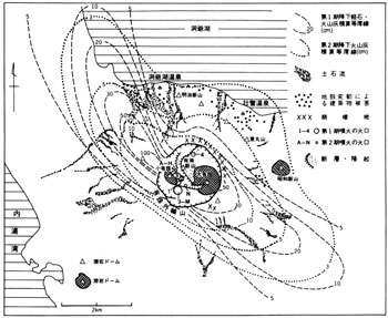
After the eruptions of the first stage, the remaining dacitic magma continued to rise resulting in uplift of crater floor accompanied with volcanic tremors and expanding fumarole area. A large fault line was formed from NE foot of Kousu to Ousu through Ogariyama. Central area of crater floor on NE side of the fault was uplifted and while moving towards NE direction a new cryptodome ( Usu-shinzan ) started to grow ( ![]() Fig. 6 ). On the SW side of the fault was developed a graben of 100 to 250 m wide and the summit area of Kousu subsided with the development of the graben. Within two and half months after the first eruption the uplift of Usu-shinzan reached 40 to 50 m, and NE wall of Usu somma bulged outward and its horizontal displacement was determined to be 48 m. The crustal movement reached northern areas and buildings there started to crumble.
Fig. 6 ). On the SW side of the fault was developed a graben of 100 to 250 m wide and the summit area of Kousu subsided with the development of the graben. Within two and half months after the first eruption the uplift of Usu-shinzan reached 40 to 50 m, and NE wall of Usu somma bulged outward and its horizontal displacement was determined to be 48 m. The crustal movement reached northern areas and buildings there started to crumble.
The second stage of the eruption started on November 16th with a small scale phreatic eruption. Similar activities continued after January 1978, and intermediate scale phreatomagmatic to magmatic eruptions occurred during July-September period. The eruption ended on October 27th. During all this time craters named A to N opened up, among which J to M were subsequently combined to become one ( Ginnuma crater ). Thickness of ash fall on crater wall was about 1 m, at the foot several cm, and total amount was estimated to be about 7.5 million m3. The amount was only one tenth of that of the first stage, yet the ash fall threatened lives of residents at the foot and gave extensive damage to forest and agricultural products.
In the second stage eruptions, fine-grained ash covered the ground surface resulting in poorer permeation of rain water than before. Because of this the rainfall on October 16th and 24th caused in large scale debris flows and many houses had collapsed or damaged with two dead and one missing ( ![]() Fig. 5 ). The rainfall triggered this disaster was only 20-30 mm/day. Meanwhile, early warning system and soil protection and erosion control dams along with five drainage ditches, which were intended to divert debris flows to Lake Toya, were installed against debris flows. Grass seeds were spread from the air to bring plant cover.
Fig. 5 ). The rainfall triggered this disaster was only 20-30 mm/day. Meanwhile, early warning system and soil protection and erosion control dams along with five drainage ditches, which were intended to divert debris flows to Lake Toya, were installed against debris flows. Grass seeds were spread from the air to bring plant cover.
Though decreasing in intensity, crustal movement continued even after the second stage activity had ended, and the Usu-shinzan reached a height of 656.8 m, about 170 m higher than before the eruption. The NE part of somma bulged outward by more than 160 m and started to collapse cut by many faults ( ![]() Figs. 5 &
Figs. 5 & ![]() 7 ). Around northern foot of Usu Volcano the ground was gradually compressed, faulted, and cracked, with the number of damaged houses counted to be 236 ( among them 74 were totally collapsed ), in addition to damage in roads, city water supplies, sewage lines, and thermal spring water distribution lines. Most of totally collapsed houses were related to fault lines happened to pass directly beneath them (
7 ). Around northern foot of Usu Volcano the ground was gradually compressed, faulted, and cracked, with the number of damaged houses counted to be 236 ( among them 74 were totally collapsed ), in addition to damage in roads, city water supplies, sewage lines, and thermal spring water distribution lines. Most of totally collapsed houses were related to fault lines happened to pass directly beneath them ( ![]() Fig. 5 ). The uplift continued until March 1982.
Fig. 5 ). The uplift continued until March 1982.
Eruption of 2000 (the 12th year of Heisei)
The seismic activity was observed on March 27th, and emergency volcanic alert was announced on 29th. This is the first-ever alert that announced before the volcanic eruption. After the evacuation of residents completed, eruption started on the northwestern side of the western foot of Mt. Nishiyama at 1:07 p.m. on March 31st. First eruption on March 31st was phreatomagmatic eruption ( or small-scale phreatoplinian eruption ) including dacitic essential materials, and their total amount was 2.2 x 10⁸ kg. Eruption column rose to a height of 3500 m and it continued for over 6 hours with intermission. Small amount of volcanic ash reached to Sapporo City ( 80 km away from Usu Volcano ). Low-temperature pyroclastic surge was also observed during eruption.
On April 1st, phreatic explosions started on the western foot of Mt. Kompira Yama, located on the extension of the 1910 crater chain. Since then, numerous explosions occurred, forming many explosion craters, in the two areas located on the western foot of Nishiyama ( Nishiyama Craters ) and Kompira Yama ( Kompira Yama Craters ). The volcanic activity in and after April was similar to that of the 1910 eruption. Explosions since April 1st were smaller than those of March 31st. However, a big eruption was observed on April 4th and its volcanic ash reached Niseko Town and Makkari Village. The amount of the volcanic product was 4.9 x 10⁷ kg. Hot mud flows discharged from several craters of Nishiyama Craters ( from April 1st to 2nd ) and those of Kompira Yama Craters ( from April 2nd to 10th ) and damaged the town of Toya-ko Onsen ( Spa ). A total of 65 craters formed until mid-April. After this, only small explosions and smoke from some regular craters were observed.
Since mid-April, considerable uplift and fault activities occurred around the western foot of Mt. Nishiyama, and a cryptodome was formed by the shallow intrusion of magma. The uplift reached 80 m high until July. The mound shape of the cryptodome is unclear because the original topography was not flat. After the crustal change stopped, activities of several craters and development of geothermal area were observed. Air shock caused by explosion was observed until September, 2001.
The craters formed by the 2000 eruption were located on the northwestern side of older craters, and it reached a pa rt of residential district. Thus, infrastructures, including water supply, sewerage, route 230 and other roads, and 850 houses ( 119 houses were completely destroyed ) were damaged by crustal movements, mud flows, and falling rocks. However, there were no victims because of the smooth evacuation activities.