Tarumae Volcano
1: Introduction / 2: General Geology of Tarumae Volcano / 3:Topography of Tarumae Volcano
4: Eruptive history of Tarumae Volcano
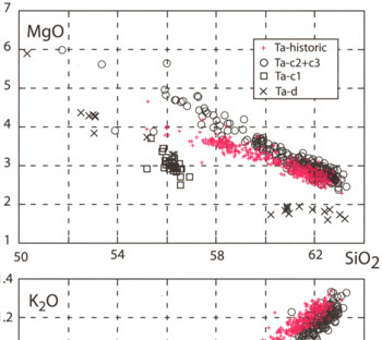
5: Petrology of Tarumae volcano
6: Monitoring of volcanic activities/ 7: Factors for mitigating volcanic hazard
Acknowledgements / References
![]() PREV
PREV ![]() NEXT
NEXT
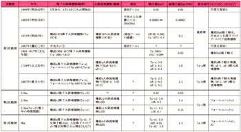
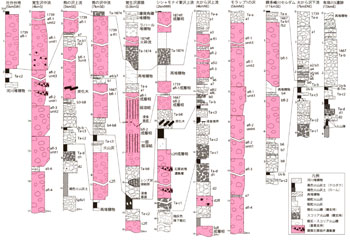
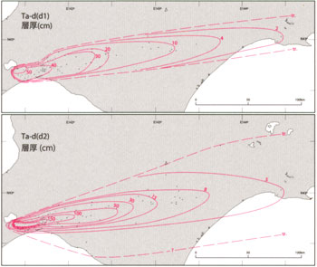
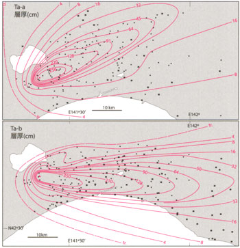
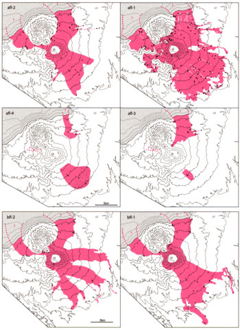
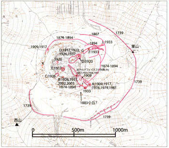
Fig.5 Crater and fumarolic vent with activity age in the summit area
Compiled from Tanakadate (1924) and Japan Meteorological Agency (2005).
Plotted on 1:5,000 Volcano base map 'tarumae-san'.
4: Eruptive history of Tarumae Volcano
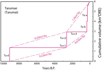
Summary : The Tarumae Volcano became active since ca. 9,000 years ago. Discriminating with dormant intervals over 1,000 years allows us to divide the activities into 3 stages (![]() Table 1). The first stage is ca. 9,000 years ago, the second from ca. 2,500 to 2,000 years ago, and the third from 1667 (7th year of Kanbun era in Japanese calendar)to the present. The representative stratigraphic sections of erupted materials and their distributions are shown in
Table 1). The first stage is ca. 9,000 years ago, the second from ca. 2,500 to 2,000 years ago, and the third from 1667 (7th year of Kanbun era in Japanese calendar)to the present. The representative stratigraphic sections of erupted materials and their distributions are shown in ![]() Fig. 1 and
Fig. 1 and ![]() 2. Note that nomenclature of the each eruptive deposits such as Ta-a and Ta-b given in previous studies are retained as far as possible.
2. Note that nomenclature of the each eruptive deposits such as Ta-a and Ta-b given in previous studies are retained as far as possible.
First Stage
Plinian eruptions occurred twice among geologically short period accompanying small pyroclastic flows. Total volume of erupted materials is estimated to be 3.8km3 (![]() Fig. 2-1). The Plinian deposits are named Tarumae-d pyroclastic fall deposits (Ta-d), and consist of lower lithologic unit, Ta-d2, and upper unit, Ta-d1. No evidence of time interval is detected between those two units. Ta-d2 consists of well vesiculated reddish orange-colored pumice with the mean density of 0.4 to 0.6 g/cm3. Within 4km from the crater Ta-d2 is occasionally intercalated with pyroclastic flow deposits (d2fl)consist of same pyroclastic material with Ta-d2. The d2fl are mostly 30cm to 1m thick with well developed stratification. The upper unit Ta-d1 consists of dark grey scoria lapilli of 1.6 to 1.8 g/cm3. The coarse-grained scoria tends to show rounded shape with network embayment like a cauliflower. At Usugawa-5 ruin in Tomakomai, ca. 15km ESE from the summit (outside of the mapped area), abundant volcanic bombs were found just beneath the Ta-d1 (Furukawa et al., 2008). Carbonized wood overlain by Ta-d2 has a radiocarbon age of ca. 10 ka (cal.)(Sato, 1971). Carbonized plant and black volcanic ash soil beneath the Ta-d2 yielded ages of 8.7 and 9.2 ka (cal.)(Furukawa et al., 2006).
Fig. 2-1). The Plinian deposits are named Tarumae-d pyroclastic fall deposits (Ta-d), and consist of lower lithologic unit, Ta-d2, and upper unit, Ta-d1. No evidence of time interval is detected between those two units. Ta-d2 consists of well vesiculated reddish orange-colored pumice with the mean density of 0.4 to 0.6 g/cm3. Within 4km from the crater Ta-d2 is occasionally intercalated with pyroclastic flow deposits (d2fl)consist of same pyroclastic material with Ta-d2. The d2fl are mostly 30cm to 1m thick with well developed stratification. The upper unit Ta-d1 consists of dark grey scoria lapilli of 1.6 to 1.8 g/cm3. The coarse-grained scoria tends to show rounded shape with network embayment like a cauliflower. At Usugawa-5 ruin in Tomakomai, ca. 15km ESE from the summit (outside of the mapped area), abundant volcanic bombs were found just beneath the Ta-d1 (Furukawa et al., 2008). Carbonized wood overlain by Ta-d2 has a radiocarbon age of ca. 10 ka (cal.)(Sato, 1971). Carbonized plant and black volcanic ash soil beneath the Ta-d2 yielded ages of 8.7 and 9.2 ka (cal.)(Furukawa et al., 2006).
Second Stage
Three Plinian eruptions intervened by short time breaks occurred during the Second Stage after quiet period of ca. 6,500 years from the First Stage (![]() Fig. 2-2). Total materials erupted during this period is estimated as 4.6km3. The earliest erupted material is Tarumae-c1 pyroclastic fall deposit (Ta-c1: Soya & Sato, 1980 etc.), consists of dark grey scoria lapilli which their mean density ranges from1.6 to 1.8 g/cm3. Pyroclastic flow deposit c1fl is intercalated with Ta-c1 chiefly consisting of scoria same with Ta-c1. The c1fl is less than 1m thick and commonly shows cross stratification. Its distribution is limited to the north and within area of 5km from the crater. Overlying Tarumae-c2 pyroclastic fall deposit (Ta-c2: Soya & Sato, 1980). The Ta-c2 is mainly consisting of light tan pumice lapilli. As the Ta-c2 ordinary overlies the Ta-c1 without intercalating soil or reworked evidence, but brown soil less than 2cm thick is developed between them at low-lying marsh deposits of 30km away from the volcano (Suzuki, 1994). Therefore, time interval between Ta-c1 and Ta-c2 is estimated as several tens to 100 years. Based on the lithology of Ta-c2, six lithologic units are identified. Juvenile light tan pumice has density ranging from 0.6 to 1.0 g/cm3 and becomes less vesiculated and contains more grey pumice toward the top. The uppermost unit composed of grey volcanic ash extends over 30km away from the crater. The pumices of the lower units include small amount of hornblende. Within 6km from the summit, pyroclastic flow deposit c2fl is intercalated within the Ta-c2. The c2fl contains abundant grey pumice and dark grey scoria clasts. The age of Ta-c2 is estimated as ca. 2.5 ka (cal.)from underlying black volcanic ash soil and peaty soil (Suzuki, 1994 etc.). Tarumae-c3 pyroclastic fall deposit follows the above mentioned units and consists mainly of fine-grained tan pumice lapilli. The Ta-c3 is relatively small than lower units and covers an area within 15km from the crater (
Fig. 2-2). Total materials erupted during this period is estimated as 4.6km3. The earliest erupted material is Tarumae-c1 pyroclastic fall deposit (Ta-c1: Soya & Sato, 1980 etc.), consists of dark grey scoria lapilli which their mean density ranges from1.6 to 1.8 g/cm3. Pyroclastic flow deposit c1fl is intercalated with Ta-c1 chiefly consisting of scoria same with Ta-c1. The c1fl is less than 1m thick and commonly shows cross stratification. Its distribution is limited to the north and within area of 5km from the crater. Overlying Tarumae-c2 pyroclastic fall deposit (Ta-c2: Soya & Sato, 1980). The Ta-c2 is mainly consisting of light tan pumice lapilli. As the Ta-c2 ordinary overlies the Ta-c1 without intercalating soil or reworked evidence, but brown soil less than 2cm thick is developed between them at low-lying marsh deposits of 30km away from the volcano (Suzuki, 1994). Therefore, time interval between Ta-c1 and Ta-c2 is estimated as several tens to 100 years. Based on the lithology of Ta-c2, six lithologic units are identified. Juvenile light tan pumice has density ranging from 0.6 to 1.0 g/cm3 and becomes less vesiculated and contains more grey pumice toward the top. The uppermost unit composed of grey volcanic ash extends over 30km away from the crater. The pumices of the lower units include small amount of hornblende. Within 6km from the summit, pyroclastic flow deposit c2fl is intercalated within the Ta-c2. The c2fl contains abundant grey pumice and dark grey scoria clasts. The age of Ta-c2 is estimated as ca. 2.5 ka (cal.)from underlying black volcanic ash soil and peaty soil (Suzuki, 1994 etc.). Tarumae-c3 pyroclastic fall deposit follows the above mentioned units and consists mainly of fine-grained tan pumice lapilli. The Ta-c3 is relatively small than lower units and covers an area within 15km from the crater (![]() Fig. 3-2).Brown soil rarely intervenes between the Ta-c3 and Ta-c2. Based on the thickness and radiocarbon age of the soil, the eruptive age is estimated as ca. 2 ka (Furukawa et al., 2006).
Fig. 3-2).Brown soil rarely intervenes between the Ta-c3 and Ta-c2. Based on the thickness and radiocarbon age of the soil, the eruptive age is estimated as ca. 2 ka (Furukawa et al., 2006).
Third Stage
Third Stage corresponds to activities from AD1667 to present. In ADs 1667 and 1739, large Plinian eruptions occurred. Since 19th century, magnitude of the eruptions reduced but over 70 small eruptions have been recorded.
Eruption of 1667 (7th year of Kanbun era)
According to a document reported from Tanabu, Shimokita Peninsula, approximately 150km south of the Tarumae Volcano, "After 8 o' clock in the evening of 23rd September, several explosive acoustic wave have been heard and eruption clouds have been observed intermittently as surrounding area has become hazy by the erupting ash from 24th to 26th of September" (Furukawa et al., 1997). Tarumae-b pyroclastic fall deposit (Ta-b)widely emplaced east of the volcano with subordinating pyroclastic flow deposit in proximal of the volcano. Total amount of erupted materials is 2.9km3. In the southern area of the Tarumae Volcano, the Ta-b overlies Usu-b pyroclastic fall deposits erupted from adjacent Usu Volcano in 1663, with intervening thin volcanic ash soil or plant fragments. The Ta-b consists of 10 lithologic units and the juvenile pumices become less vesiculated and contains more grey-colored pumices and dark gray scoriae clasts toward the top (![]() Fig. 2). The pyroclastic flow deposits are interbedded with pumice fall deposit at 2 horizons. The lower bfl-2 pyroclastic flow deposit consists of several flow units and each flow unit is massive and includes white to grey juvenile pumice blocks and lapilli. The fall unit Ta-b5 consists of ash fall and fine-grained pumice fall and is a stratigraphic equivalent with the bfl-2. The upper pyroclastic flow deposit, bfl-1, contains dark grey pumice and dark brown scoria blocks and lapilli. The fall unit Ta-b3 consists of pumice lapilli and ash fall and stratigraphically coeval with bfl-1. The Kuchinashinuma Pond, in upstream of Nishitappugawa , and Moritanuma Pond, downstream of Tarumaegawa, are presumably formed by damming of bfl-2 and bfl-1. At Numanohata, eastern Tomakomai (outside of mapped area), several buried dugout canoe was discovered in the Ta-b (Tarumae City, 1966). Dendroclimatology revealed this eruption had prohibited tree ring growth of eastern area of the Tarumai (Oka & Takaoka, 1996).
Fig. 2). The pyroclastic flow deposits are interbedded with pumice fall deposit at 2 horizons. The lower bfl-2 pyroclastic flow deposit consists of several flow units and each flow unit is massive and includes white to grey juvenile pumice blocks and lapilli. The fall unit Ta-b5 consists of ash fall and fine-grained pumice fall and is a stratigraphic equivalent with the bfl-2. The upper pyroclastic flow deposit, bfl-1, contains dark grey pumice and dark brown scoria blocks and lapilli. The fall unit Ta-b3 consists of pumice lapilli and ash fall and stratigraphically coeval with bfl-1. The Kuchinashinuma Pond, in upstream of Nishitappugawa , and Moritanuma Pond, downstream of Tarumaegawa, are presumably formed by damming of bfl-2 and bfl-1. At Numanohata, eastern Tomakomai (outside of mapped area), several buried dugout canoe was discovered in the Ta-b (Tarumae City, 1966). Dendroclimatology revealed this eruption had prohibited tree ring growth of eastern area of the Tarumai (Oka & Takaoka, 1996).
Eruption of 1739 (4th year of Genbun)
A large earthquake occurred on 16th August and eruptions were recorded intermittently from 18th to 30th of the same month. In two or three days within this period, ash fall was so intense to darken the sky. The acoustic wave of explosions was extremely strong at the end of the eruption (Ishikawa et al., 1972 etc.). During these eruptions Tarumae-a pyroclastic fall deposit (Ta-a)emplaced widely to northeastern areas of the Tarumai with accompanying pyroclastic flow deposited in proximal of the volcano. Total volume of erupted materials is estimated as 4.5km3. The Ta-a consists of 9 lithologic units. The lowermost unit Ta-a9 is proximal ash fall. The next Ta-a8 is rich in black scoria and grey pumice clasts, but units over the Ta-a8 are mainly composed of white pumice clasts and mutual ash. The uppermost fall unit Ta-a1 consists of white pumice clasts which are less vesiculated and rich in crystals. As the Ta-a1 has widest distribution and thickest among Ta-a, it is consistent with the historical document which largest acoustic wave has been reported at the end of eruption. The pyroclastic flow deposits emplaced within 10km from the crater and 4 horizons (afl-1 to afl-4 in descending order) are recognized interbedded within the Ta-a. The flow units of afl-4 and afl-3 occur as massive facies within 6km from the summit in the upstream of Okarasawa and Oboppusawa. The stratified facies made of thin bedded coarse ash fringe the massive facies. All the above consist mainly of white pumice clast and ash. Distal equivalent of the afl-4 is the ash fall unit Ta-a7. Massive facies of afl-2 is rich in grey pumice clast and distributed within 7km of the summit and shows more than 10m thick at upstream of Okarasawa and Oboppusawa. Pyroclastic flow deposit afl-1 flowed down in all directions within 10km of the summit. It consists mainly of white pumice clasts and massive facies is ordinary 2 or 3m thick. On the slope of pyroclastic cone, the afl-1 shows long wave-length cross stratified with dune topography. Distal equivalent of the afl-1 is a pyroclastic fall unit Ta-a3. At least the pyroclastic flows from afl-1 to afl-3 flowed into the Lake Shikotsu at northern and northwestern shore. Stratified fine ash fall deposits up to 1m thick are distributed around the lake shore of Morappu and northwestern slope of the Fuppushi Volcano. On the shore of the Morappu a light tan white pumice of over 5m diameter is found which is interpreted to have drifted from secondary explosion of the pyroclastic flow afl-1 and the lake water. In the sketches of Shibue Chohaku who travelled this area in 1799 (11th year of Kansei)and in a picture book ' Nihon Meizan Zufu' (Catalogue of famous mountains of Japan)published in 1804 (1st year of Bunka), neither lava dome nor rising steam was described, suggesting that large lava dome was not formed nor there are small fumarolic activity (Ishikawa et al., 1972). In the northern hemisphere density of yearly tree ring have changed in AD 1740 (Briffa et al., 1998)suggesting the eruption of 1739 affected global climate.
Eruptive activities since 19th century
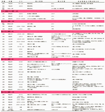
More than 70 eruptions and associated activities have been recorded since 19th century. At least five eruptions were accompanied with magma effusions.![]() Table 2 lists the activities with some eruptive deposition or obvious surface change.
Table 2 lists the activities with some eruptive deposition or obvious surface change. ![]() Fig. 5 summarizes the topography of the summit area corresponding each eruption. During 1804 to 1817 (Bunka era), fine-grained pyroclastic fall deposit (Ta-1804-1817) erupted. Detail of the eruption is not known except for hearsay document (Ishikawa et al., 1972). Its exposure is limited n the northeastern side within 2km from the summit. During 1867 eruption, from 5 to 9cm ash and lapilli fall was reported at Shiraoi, but no deposit have been identified yet. Before the 1874 eruption, some document reported a flat-topped pyroclastic cone and small lava dome within the crater. Therefore the formation of the present Central pyroclastic cone and the Lava Dome-1 can be correlated with 1867 eruption record. The Lava Dome-1 was short-lived and destroyed by the 1874 eruption. The pyroclastic fall (Ta-1874) and pyroclastic flow (1874fl) deposits emplaced at 1874. The 1874fl consists of scoria blocks and lapilli at northwestern side of the summit while it consists mainly of white to grey tan pumice in northeastern and southern sides. The 1874fl forms terminal lobate morphology. In the eruption of 1883, the eruption was ash fall and a small hummock was formed in south part of the crater. It is not clear whether the small hummock was a lava dome or pyroclastic cone. It disappeared before the eruption of 1894. The main crater of the Central pyroclastic cone had widened until 550m in diameter. In 1909 small-phreatic eruption and acoustic wave have continued intermittently through three months, and two explosive eruptions occurred ejecting bombs around the crater and pyroclastic fall in proximal of the volcano. Just after the acoustic wave and fumarolic plume had decreased in the afternoon of 17th April, a formation of new lava dome commenced accompanying with intense glowing. On 19th a new lava dome on the summit was observed. On 23rd April and 2nd May topographic survey was carried out. The lava dome was mostly formed during 17th and 23rd of April and seemed to have continued to grow slowly until 2nd of May. After then, fissure crater named "Old Faithful Fissures" was formed extending from southeast of the lava dome to central cone by small explosions (Tanakadate, 1924). In 1917, relative height of the lava dome was decreased making the talus stepwise in northwestern side. After 1917 eruption, NE-SW oriented fissures were formed by repeated ash eruptions. At the eruption on 30th October 1926, however the eruption column was 2km high, ash fall reached shore of Okhotsk (Ishikawa et al., 1972). Activities in 1944 to 1955 and 1979 to 1981 were small ash falls with minor mudflows from the A-Crater. On 14th May 1978 ash was erupted from A-Crater and ash fall was reported at the shore of Lake Shikotsu. A pulverulent flow made of accessory ash with temperature over 220°C were emitted from the crater and flowed down for ca. 100m (Katsui et al., 1979). In 2001 and 2003, the highest temperature of the crater reached over 600ºC at times and in 2002 and 2003, sand and mud were emitted from the A-Crater (Japan Meteorological Agency, 2005).
Fig. 5 summarizes the topography of the summit area corresponding each eruption. During 1804 to 1817 (Bunka era), fine-grained pyroclastic fall deposit (Ta-1804-1817) erupted. Detail of the eruption is not known except for hearsay document (Ishikawa et al., 1972). Its exposure is limited n the northeastern side within 2km from the summit. During 1867 eruption, from 5 to 9cm ash and lapilli fall was reported at Shiraoi, but no deposit have been identified yet. Before the 1874 eruption, some document reported a flat-topped pyroclastic cone and small lava dome within the crater. Therefore the formation of the present Central pyroclastic cone and the Lava Dome-1 can be correlated with 1867 eruption record. The Lava Dome-1 was short-lived and destroyed by the 1874 eruption. The pyroclastic fall (Ta-1874) and pyroclastic flow (1874fl) deposits emplaced at 1874. The 1874fl consists of scoria blocks and lapilli at northwestern side of the summit while it consists mainly of white to grey tan pumice in northeastern and southern sides. The 1874fl forms terminal lobate morphology. In the eruption of 1883, the eruption was ash fall and a small hummock was formed in south part of the crater. It is not clear whether the small hummock was a lava dome or pyroclastic cone. It disappeared before the eruption of 1894. The main crater of the Central pyroclastic cone had widened until 550m in diameter. In 1909 small-phreatic eruption and acoustic wave have continued intermittently through three months, and two explosive eruptions occurred ejecting bombs around the crater and pyroclastic fall in proximal of the volcano. Just after the acoustic wave and fumarolic plume had decreased in the afternoon of 17th April, a formation of new lava dome commenced accompanying with intense glowing. On 19th a new lava dome on the summit was observed. On 23rd April and 2nd May topographic survey was carried out. The lava dome was mostly formed during 17th and 23rd of April and seemed to have continued to grow slowly until 2nd of May. After then, fissure crater named "Old Faithful Fissures" was formed extending from southeast of the lava dome to central cone by small explosions (Tanakadate, 1924). In 1917, relative height of the lava dome was decreased making the talus stepwise in northwestern side. After 1917 eruption, NE-SW oriented fissures were formed by repeated ash eruptions. At the eruption on 30th October 1926, however the eruption column was 2km high, ash fall reached shore of Okhotsk (Ishikawa et al., 1972). Activities in 1944 to 1955 and 1979 to 1981 were small ash falls with minor mudflows from the A-Crater. On 14th May 1978 ash was erupted from A-Crater and ash fall was reported at the shore of Lake Shikotsu. A pulverulent flow made of accessory ash with temperature over 220°C were emitted from the crater and flowed down for ca. 100m (Katsui et al., 1979). In 2001 and 2003, the highest temperature of the crater reached over 600ºC at times and in 2002 and 2003, sand and mud were emitted from the A-Crater (Japan Meteorological Agency, 2005).