Suwanosejima Volcano
1: Introduction / 2: The topography of Suwanosejima Volcano
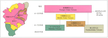
3: Geological history
4: Products during the historical age / 5: Petrology
6: Recent activities
7: Geophysical observations / 8: Characteristics of the recent activity and hazards
References
![]() PREV
PREV ![]() NEXT
NEXT
1: Introduction / 2: The topography of Suwanosejima Volcano
1: Introduction
Suwamosejima Volcano is an active volcano, consisting of Suwanosejima Island of the Tokara Islands. This volcano is an andesitic stratovolcano, which is situated on the volcanic front along the Ryukyu Arc. The crater in the central part of the island, named Otake crater, has been active for more than fifty years with strombolian and small vulcanian eruptions (Japan Meteorological Agency, 2013).
Despite its intense activity, the oldest eruptive record of Suwanosejima Volcano only goes back to the large eruption in 1813 (Bunka Eruption). There are no adequate records of recent activities either until the 1990s, except for some occasional reports. Geological studies of Suwanosejima were first reported by Omori (1918), followed by Hirayoshi (1983) and Hirasawa and Matsumoto (1983). Kobayashi (2000) and Shimano and Koyaguchi (2001) reconstructed the sequence of the 1813 eruption.
The geological map of Suwanosejima Volcano was formed based on the results of previous studies and the additional field survey. The geophysical descriptions are the summary of the results of the observations carried by many institutes, and based on the “Report of the 3rd Joint Observation of Suwanosejima Volcano (October 1998)” by Disaster Prevention Research Institute (DPRI), Kyoto University (1998).
2: The topography of Suwanosejima Volcano
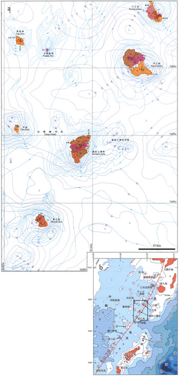
Suwanosejima is an island with a conical edifice with a long and short axis of ca. 8.7 and 4 km, and the area ca. 28 km2 respectively (![]() Fig. 1). The island is the second largest among the Tokara Islands. The altitude of the summit is 796 m above sea level (asl) and has a total height of ca. 1400 m above the seafloor, which is 500-600 m below sea level (bsl). There are two heights in the sea whose peaks are at 100 m and 300 m bsl, ca. 10 km to the east and ca. 10 km to the northwest of the island, respectively.
Fig. 1). The island is the second largest among the Tokara Islands. The altitude of the summit is 796 m above sea level (asl) and has a total height of ca. 1400 m above the seafloor, which is 500-600 m below sea level (bsl). There are two heights in the sea whose peaks are at 100 m and 300 m bsl, ca. 10 km to the east and ca. 10 km to the northwest of the island, respectively.
Suwanosejima Island is mostly surrounded by steep cliffs. The east-side cliff of an old edifice, Tondachidake Volcano, is up to ca. 500 m high. In contrast, the height of the cliff is about 10-20 m near Sakuchi and Akazumi, where younger volcanic edifices have developed on the eastern and western side of the island, respectively. There are also many beaches, of which Sakuchibama is the largest. Smaller beaches develop at Taisenbama, Suigo, Totabama, Fukaura, Kurogai, Teisaibama, Kiriishi and Nahabama. Some minion coral reefs have developed near Makkodai and Wakiyama, along the southern and northwestern coast of the island.
Suwanosejima Island consists of a few volcanoes that have volcanic centers at different ages and locations (![]() Fig. 2). Nabedao Volcano in the southern part and Tondachidake Volcano in the northern part of the island are edifices of the oldest volcanoes. Otake Volcano, in the central part of the island, covers a major part of Suwanosejima Volcano where most of the volcanic activities in the Holocene occurred.
Fig. 2). Nabedao Volcano in the southern part and Tondachidake Volcano in the northern part of the island are edifices of the oldest volcanoes. Otake Volcano, in the central part of the island, covers a major part of Suwanosejima Volcano where most of the volcanic activities in the Holocene occurred.
Tondachidake Volcano is deeply eroded, with an edifice that has many radial gullies and valleys surrounding the summit, and has almost no smooth primary slopes. Nabedao Volcano is also deeply eroded but still has a crater-like topographic depression on the summit. Makkodai in the southern end of the island consists of flat lava flows that had been effused from Nabedao Volcano. Otake Volcano is a composite volcano with an elongated outline in the NNE-SSW direction. The summit of Mt. Otake is at the center of this volcano, on top of a horseshoe-shaped cliff facing eastwards and surrounding the active Otake crater (Sakuchi Caldera). The cliff consists of several smaller segments. In the southern part, these segments show a double- or multi-step topography. Though the formation age of Sakuchi Caldera is unknown, the distribution and stratigraphic relation of the collapse materials suggests that the part surrounding the Otake crater was formed during the 1813 eruption.
The Otake Pyroclastic Cone in Sakuchi Caldera is a flat-shaped cone as large as 600 m and 80 m in diameter and height, respectively, with a crater 400 m in diameter. All the eruptions to date after the last stage of the 1813 eruption occurred at this crater. To the southwest of the summit, there is another crater called “Kyukako” with a diameter of 300 m.
There are some well-preserved lava flows on the slope of Otake Volcano. Two lava flows on the western slope down to the shoreline of Akazumi and Taisenbama were effused during the 1813 eruption. The fresh lava morphologies of the lavas of 1884-85 are preserved in the area from Otake crater down to the eastern shoreline in Sakuchi Caldera.
A lineament in the ENE-WSW with a 20-m gap (N down) and another in the NW-SE (E down) in the southern part of the island are perpendicular to each other and have been classified as active faults with degree of accuracy II (Research Group for Active Faults of Japan, 1991). The locations of these faults are after the Research Group for Active Faults of Japan (1991).
![]() PREV
PREV ![]() NEXT
NEXT