Nasu Volcano
Introduction / Geology of Nasu volcano and environs / Outline of Nasu volcano
Rocks of Nasu Volcano
Eruptive history and mode of eruption of Chausudake Volcano
Eruptions of 1408 - 1410 / Eruptions of recent times
Surveillance of volcanic activities / Prediction of future activities
Acknowledgments / References
![]() PREV
PREV ![]() NEXT
NEXT
Introduction / Geology of Nasu volcano and environs / Outline of Nasu volcano
Introduction
Nasu Volcano Group ( NVG ) is a group of Quaternary stratovolcanoes situated at the boundary of Tochigi and Fukushima Prefectures and consisting of Minami-Gassan, Chausudake, Asahidake, Sanbonyaridake, and Kasshi-Asahidake roughly aligned from south to north. Among those Chausudake is currently active with fumaroles with several eruptions recorded in the historical times. In 1410, eruption was said to have caused 180 deaths. The latest eruption occurred in 1963. Around the volcano, holiday facilities, golf links, skiing grounds, and amusement parks are developed with an aerial railway going up Chausudake. Except in winter, crater area is crowded by visitors nearly in all the time. Therefore, prediction of eruption and prevention of disaster are very important. Understanding the geohistory of Nasu Volcano would be the first step towards this direction.
The map is prepared to summarize geology and geohistory of Nasu Volcano. It is hoped that this is widely utilized not only for future scientific studies but also for mitigation of disaster as well as for sightseeing.
Geology of Nasu Volcano and environs
NVG is geologically situated at the boundary between Oga Mountains consisting of Pre-Quaternary basement ( Cretaceous plutonic rocks and Miocene volcanic rocks ) in the west and hill province consisting of early Pleistocene Shirakawa pyroclastic flow deposits ( 1.4 to 1 Ma ) in the east. Pre-Quaternary rocks and Shirakawa pyroclastic flow deposits are in contact with westward thrusting reverse fault and the framework of current topography was formed by Quaternary fault movements. NVG is influenced by these fault movements while Sekiya fault in SW foot area and Kenkatsura and Nasuyumoto-Hokuto fault in NE foot area deformed the volcanic body. However, along Sekiya fault for at least 10,000 years, and along two faults in NE area for 16,000 years, no clear indication of movement is recognized, thus those faults seem to be not active in recent times.
Outline of Nasu Volcano
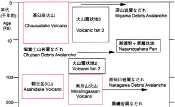
NVG consists of the following volcanoes in the order of their ages; Kasshi-Asahidake, Sanbonyaridake, Asahidake, Minami-Gassan, and Chausudake ( ![]() Fig.1 ). They have respective eruptive centers of their own. Kasshi-Asahidake is basalt to andesite stratovolcano and was active about 500,000 yBP. The eruptive center is located outside of the map area to the north. Towards the end of its activity, dacite was erupted as Kamafusa pyroclastic flow in the NE foot area which is outside of the map area. Kasshi-Asahidake Volcano is significantly dissected and original volcanic features are mostly lost. Sanbonyaridake Volcano just to the south of Kasshi-Asahidake was active stratovolcano about 300,000 yBP. It consists of early ejecta of basalt to andesite lavas and pyroclastic rocks and thick late ejecta of andesite to dacite lavas. It is overlain with distinct unconformity by Asahidake volcanic ejecta. Without Asahidake ejecta, its shape is a horse-shoe crater open to SE. Steep cliff of south Akatsurayama represents a part of crater wall suggesting collapse of the body of Sanbonyaridake Volcano at one time. On the other hand, Kuroiso debris avalanche deposits at least 200,000 yBP from tephrochronological data are widely distributed from Takahisa Hills on the east foot of NVG to an area along Nakagawa River. This debris deposits are interpreted to be products of collapse of Sanbonyaridake Volcano. Asahidake Volcano was an andesite stratovolcano active about 200,000 to 100,000 yBP. It grew on top of debris of Sanbonyaridake Volcano. Minami-Gassan and Asahidake Volcanoes to the south of Asahidake Volcano were stratovolcanoes active nearly at the same time with Asahidake at 200,000 to 100,000 yBP but form independent bodies. Minami-Gassan Volcano consists of early ejecta of basalt and andesite and late ejecta of dacite, andesite, and basalt. It collapsed about 170,000 to 140,000 yBP and deposited Nakagawa debris avalanche in the south. Steep cliff line from Shirasasayama to Takaosan represents remnant of this collapse. Inside of collapse was subsequently buried by Osoyama lavas. In the east foot area of NVG, Ofujisan debris avalanche deposits, which are 40,000 to 30,000 yBP old, spread widely and covers both Kuroiso and Nakagawa debris avalanche deposits with intervening thick eolian deposits. Ofujisan debris avalanche deposits were derived from SE slope of Asahidake Volcano and steep cliff line north of Iimoriyama represents remnant of this collapse. The newest volcano in NVG, Chausudake Volcano, started its activity about 16,000 years ago. Most lavas and pyroclastic rocks have deposited in the east, but part of ejecta has deposited upstream area of Nakagawa River in the west. Last eruption of lava occurred in 1410 and the summit of Chausudake was formed. Volcanic fan deposit 3 had deposited from that time but stopped to grow for thousand of years since. It is debris avalanche consisting mainly of andesite boulders. In the upstream area of Nakagawa River to the west of Chausudake, Miyama debris avalanche deposits created in about 13th century is distributed with intercalation of volcanic ejecta of Chausudake Volcano.
Fig.1 ). They have respective eruptive centers of their own. Kasshi-Asahidake is basalt to andesite stratovolcano and was active about 500,000 yBP. The eruptive center is located outside of the map area to the north. Towards the end of its activity, dacite was erupted as Kamafusa pyroclastic flow in the NE foot area which is outside of the map area. Kasshi-Asahidake Volcano is significantly dissected and original volcanic features are mostly lost. Sanbonyaridake Volcano just to the south of Kasshi-Asahidake was active stratovolcano about 300,000 yBP. It consists of early ejecta of basalt to andesite lavas and pyroclastic rocks and thick late ejecta of andesite to dacite lavas. It is overlain with distinct unconformity by Asahidake volcanic ejecta. Without Asahidake ejecta, its shape is a horse-shoe crater open to SE. Steep cliff of south Akatsurayama represents a part of crater wall suggesting collapse of the body of Sanbonyaridake Volcano at one time. On the other hand, Kuroiso debris avalanche deposits at least 200,000 yBP from tephrochronological data are widely distributed from Takahisa Hills on the east foot of NVG to an area along Nakagawa River. This debris deposits are interpreted to be products of collapse of Sanbonyaridake Volcano. Asahidake Volcano was an andesite stratovolcano active about 200,000 to 100,000 yBP. It grew on top of debris of Sanbonyaridake Volcano. Minami-Gassan and Asahidake Volcanoes to the south of Asahidake Volcano were stratovolcanoes active nearly at the same time with Asahidake at 200,000 to 100,000 yBP but form independent bodies. Minami-Gassan Volcano consists of early ejecta of basalt and andesite and late ejecta of dacite, andesite, and basalt. It collapsed about 170,000 to 140,000 yBP and deposited Nakagawa debris avalanche in the south. Steep cliff line from Shirasasayama to Takaosan represents remnant of this collapse. Inside of collapse was subsequently buried by Osoyama lavas. In the east foot area of NVG, Ofujisan debris avalanche deposits, which are 40,000 to 30,000 yBP old, spread widely and covers both Kuroiso and Nakagawa debris avalanche deposits with intervening thick eolian deposits. Ofujisan debris avalanche deposits were derived from SE slope of Asahidake Volcano and steep cliff line north of Iimoriyama represents remnant of this collapse. The newest volcano in NVG, Chausudake Volcano, started its activity about 16,000 years ago. Most lavas and pyroclastic rocks have deposited in the east, but part of ejecta has deposited upstream area of Nakagawa River in the west. Last eruption of lava occurred in 1410 and the summit of Chausudake was formed. Volcanic fan deposit 3 had deposited from that time but stopped to grow for thousand of years since. It is debris avalanche consisting mainly of andesite boulders. In the upstream area of Nakagawa River to the west of Chausudake, Miyama debris avalanche deposits created in about 13th century is distributed with intercalation of volcanic ejecta of Chausudake Volcano.
![]() PREV
PREV ![]() NEXT
NEXT