Izu-Oshima Volcano
1: Introduction / Topography of Izu-Oshima
2: Geology of Izu-Oshima Volcano
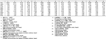
3: Rocks of Izu-Oshima Volcano
4: Historical outline of Izu-Oshima Volcano after the formation of caldera
5: Activities after 19th century
6: Monitoring / Points to be watched for disaster prevention
7: References
![]() PREV
PREV ![]() NEXT
NEXT
Monitoring / Points to be watched for disaster prevention
Monitoring
The Japan Meteorological Agency ( JMA ) installed eight seismographs and eight tiltmeters throughout the island and the data have been continuously monitored by telemetry at Oshima Observatory along with gathering other data such as electronic distance measurements and temperature monitoring within the crater of Mt. Miharayama.
Izu-Oshima Volcanic Observatory of the Earthquake Research Institute ( ERI ), University of Tokyo, installed 18 seismographs and 13 magnetometers at many points in the island, and engaged in continuous and repeated observations of earthquakes, tilting, magnetism, specific resistance, gravity, and electronic distance measurements. National Research Institute for Earth Science and Disaster Prevention ( NIED ) is engaged in continuous monitoring of earthquakes, tilting, stress, and geomagnetism. Geographical Survey Institute ( GSI ) has been engaged in continuously monitoring using GPS and tide gage. Also many institutions such as University of Tokyo, Tokyo Institute of Technology, and Hydrographic Department of Japan Coast Guard, are engaged occasionally in temporary observations. On this geologic map, continuous monitoring bases of JMA, ERI, NIED, and GSI, are shown.
Points to be watched for disaster prevention
In Izu-Oshima, eruptions leaving large deposit over several hundred million tons on the flanks outside of the caldera have been repeated every 100 to 150 years for the last 200,000 years. During last 200 years, eruptions leaving several ten million tons of lava in the caldera occurred every 30 to 40 years. Those eruptions tend to start from the summit of Mt. Miharayama and tend to show a cyclic pattern starting from lava fountain and Strombolian eruption, followed successively by lava flow, explosive eruption with the formation of pit crater, and then the eruption ends. The whole cycle tend to have around ten something years.
Forerunner of the eruption is volcanic tremor and small earthquakes both of which occur several months to several hours before the eruption. Actual eruption starts with lava fountain at the summit crater. Scoria fall may occur on the leeward. In large-scale eruptions the thickness of scoria fall may reach several tens of cm to several m thick at the flanks of the mountain.
If outpouring of lava continues and fills pit crater and summit crater, the lava flows out to fill caldera floor. As lava flows down toward low-lying area, prediction of the range of lava flow is reasonably easy.
However, not all large-scale eruptions start from the summit. There were some examples starting from fissures on the flanks, and medium-sized eruption of 1986 started not from the summit of Mt. Miharayama. Some flank eruptions may start within residential areas at the foot of the mountain. If the vent is located below 100 m a.s.l., the magma would react with sea water and/or groundwater leading to phreatomagmatic explosions. In the eruption of 1986, earthquake became frequent from only a couple of hours before the commencement of eruption with newly opened fissure. Probably creation of new crater is accompanied with local earthquakes and crustal movements, so these forerunner phenomena have to be carefully watched.
In the medium-scale eruptions after the middle of Meiji era, explosive activities were observed when a new eruption resumed from pit crater. The 1957 eruption, with a number of casualties, was one of such explosive occasions accompanied with revival of buried pit crater. In large-scale eruptions, small-scale pyroclastic flow deposits, derived from phreato( magmatic ) explosions, may accompany within 1 km of Mt. Miharayama. Though the amount of ejecta is not large, they are product of explosive activity and difficult to predict, so this type of activity should carefully be watched. Ash fall and volcanic gas emission tend to be active at this stage resulting in damage to agricultural produces.
The largest volcanic hazard predicted at Izu-Oshima is large-scale phreatomagmatic eruption accompanying caldera collapse at the summit area and resultant pyroclastic flow. Pyroclastic flow deposit of S2 member covers all the island irrespective of topography, and for this type of eruption only possible countermeasure is to evacuate the island. It seems that before the phreatic explosion of S2, eruptions from multiple vents on the side of the mountain and large-scale bulging of the whole island were likely to have proceeded. Magma compositions before and after the formation of caldera are found to be different, suggesting large-scale supply of new magma from the depth at this stage. By monitoring remarkable bulge of the island, it may be possible to predict large eruption. However, it is difficult to predict such activity with high precision at the moment.