Komagatake Volcano
1: Introduction / Geology of Komagatake Volcano and environs / Outline of Komagatake Volcano
2: Geology and history of activities of Komagatake Volcano
3: Eruptions of Komagatake Volcano in historical times
4: Rocks of Komagatake Volcano
5: Surveillance and observation of volcanc activities - Future surveillance and prevention of disaster
6: References
![]() PREV
PREV ![]() NEXT
NEXT
5: Surveillance and observation of volcanc activities - Future surveillance and prevention of disaster
Surveillance and observation of volcanc activities
Observation of Komagatake Volcano had been carried out at Hakodate Meteorological Station ( reorganized as Marine Meteorological Observatory ) 35 km away since 1927. After the large eruption of 1929 seismograph and Ishimoto-type tiltmeter were temporarily installed along with leveling survey in 1930, 1931, and 1934. As a result it became clear that the volcano subsided with the eastern half as center of subsidence.
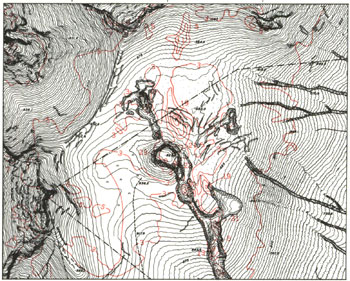
Since then the Meteorological Agency opened Komagatake Seismic Observatory 4.5 km southwest of the summit in 1959 followed by installation of three-component seismograph 4.0 km west from the summit and continuous observation has been carried out. Also observation of outgas temperature has been done regularly. Other temporary observations on earthquakes, gravity, ground temperature, and geomagnetism have been carried out by Mobile Observation Team of Meteorological Agency, Science Faculty of Hokkaido University, Usu Volcano Observatory of Science Faculty of Hokkaido University, and Geographical Survey Institute ( ![]() Fig. 9 ).
Fig. 9 ).
At the moment, Meteorological Agency installed seismograph 4.1 km WSW of the summit and continuously monitoring seismic activity through telemeter at Mori Meteorological Station. On-site inspections several times a year at summit area and daily surveillance with telescope are also carried out in addition. Usu Volcano Observatory installed five seismographs around the foot of the volcano to check seismic activity continuously through telemeter. Also repeated surveys on changes in distance, leveling, gravity, and geomagnetism have been in operation.
Future surveillance and prevention of disaster
Komagatake Volcano has been involved in four large Plinian eruptions since 1640. All of them were accompanied with pyroclastic flows which caused damages. In addition, many small eruptions were recorded. As is listed in Table 2, no regular pattern is recognized as to the intervals. About 60 years passed since large eruption of 1929, and about 50 years from middle-scale eruption of 1942, and resumption of activity becomes more imminent with passage of time.
Based on eruption history and structure of the volcano, the most likely place of future eruption would be within the summit crater floor. The likely mode of eruption for middle to small scale activity seems to be phreatic, but large scale eruption would generate large amount of pumice and ash as falls that would be accompanied with pyroclastic flows. Volumetrically, pyroclastic flow would be largely consisting of pumice accompanied with small-scale surge. Pumice flow comes down along valley and spread like a fan on reaching the foot area. Preceding or during pumice flow, little in volume but fast-moving pyroclastic surge would accompany the flow and spread on the flank forming wave-like topography. Catastrophic activity would last only a short time of 1-3 days judged from past experiences.
Pumice of historical times are intermediate andesite in bulk composition and just slightly more silicic than those in stratovolcano stage. Groundmass glass composition, which represents magma, is very rich in SiO2. Rapid vesiculation of silicic magma would generate violent pumice eruption by releasing oversaturated pressure. It is considered that because Komagatake ejects large amount of magma as pumice and ash in a short time by catastrophic activity, it becomes dormant for several tens of years or longer. As the period of severe activity is short as compared to dormant stage, disaster prevention measures should be taken in a short time and very effective.
Actual mode of eruption and size are difficult to predict precisely, but the following two cases may be fairly realistic based on the eruptive history and nature of magma.
Middle to small scale eruption: Phreatic to phreatomagmatic eruption. In recent years, small scale 1935-1938 eruption and middle scale 1942 eruption are the examples. During these eruptions volcanic blocks fell in an area of flank 2-3 km from the crater. Lapilli and ash would reach distant places and their thickness would be up to 1-3 cm on the foot. In middle scale eruption of 1942, wet ash ( pyroclastic surge ) came down the slope in three directions, south, southeast, and ESE and deposited 2-3 cm ash on the foot areas.
Large scale eruption: Examples are large scale eruptions of 1640, 1694, and 1929. Main points predictable are;
Opening of new crater and fissure
Ejection of small amount of volcanic blocks and ash
Collapse of part of mountain - debris avalanche - tsunami ( like in 1640 )
Ejection of large amount of pumice and ash, and emergence of pyroclastic flow ( pumice flow and pyroclastic surge )
Development of secondary mud flow ( debris flow )
Formation of lava dome ( like in 1856 )
Etc. Even at the beginning of large eruption, predicted initial stage would be similar to middle to small scale eruptions. It would be difficult to judge if the eruption stops at middle to small scale or changes to large scale. The 1640 eruption was commenced after nearly 3,000 years' dormant period and accompanied with collapse of part of the mountain which caused tsunami resulting in many casualties along Funka-Wan coast. In case of pumice eruption, the fall would concentrate in eastern directions of the crater. The thickness of deposited pumice would be 1 m at the foot areas, and at 50 km away from the volcano up to 10 cm. Furthermore, high temperature ( 700?C - 800?C ) pyroclastic flow (pumice flow and pyroclastic surge ) would be predicted to come down in all directions. The time it would take for the flow to reach 5-7 km is about 20 minutes. Because the summit peaks ( Kenga-Mine, Sahara-Dake, and Sumida-Mori ) surrounding the crater acting as barriers, outside slopes of these peaks would be exempted from being hit by the flow. However, other directions, east, southwest, and northwest the pyroclastic flow would reach the foot. After pyroclastic flow activity, lava dome might be formed. The activity would weaken rapidly after this stage. Secondary mud flow ( debris flow ) might cause disaster if volcanic activity is followed by rainfall.
If those predictions of eruptive activities are correct, disasters would take the forms of debris avalanche, pumice and ash fall, pyroclastic flow, pyroclastic surge, and secondary mud flow. The area affected by those would depend on the type. Pumice and ash fall affect large area but the area depends on the prevailing wind direction. At the mountain foot the thickness may reach up to 1 m. Falling blocks and volcanic bombs would be restricted within 2-3 km from the crater on the flanks of the mountain. Debris avalanche, pyroclastic flow and surge would come down the mountain at high speed and most dangerous, but pyroclastic flow and surge could reach only 5-7 km. Debris avalanche is not restricted at the foot but all the coastal areas of Funk-Wan, especially Usu coast, where coast line is complex, may suffer severe damage.
In addition, not directly related to eruption, but we should be alert for secondary mud flow ( debris flow ) after heavy rain.