Komagatake Volcano
1: Introduction / Geology of Komagatake Volcano and environs / Outline of Komagatake Volcano
2: Geology and history of activities of Komagatake Volcano
3: Eruptions of Komagatake Volcano in historical times
4: Rocks of Komagatake Volcano
5: Surveillance and observation of volcanc activities - Future surveillance and prevention of disaster
6: References
![]() PREV
PREV ![]() NEXT
NEXT
3: Eruptions of Komagatake Volcano in historical times
Many records of eruptions after 1640 exist. Especially, pyroclastic flow ( pumice flow ) was witnessed during pumice eruption of 1929. This was studied in detail by many researchers (Tsuya et al., 1930; Kozu et al., 1932; and others). For historical eruptions Katsui et al. ( 1975 ) studied old documentary records and correlated the records with actual deposits. Notable was the age of Ko-c2 pumice fall/pyroclastic flow being identified by discovery of an old record, and it was confirmed that the activity was in 1694 ( Katsui and Ishikawa, 1981 ). Furthermore, it was confirmed that in the eruption of 1640 a pyroclastic flow accompanied ( Katsui and Chimoto, 1985 ).
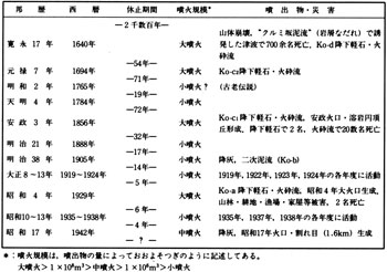
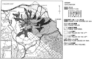
With those studies, four large pumice eruptions were identified for Komagatake in historical times, 1640, 1694, 1856, and 1929, and for every eruption pyroclastic flow accompanied ( ![]() Table 2 ).
Table 2 ).
Eruption of 1640 ( 17th year of Kan-ei )
According to 'Matsumae Nennen-Ki' ( Yearly Records of Matsumae ) and other historical documents, on July 31st of 1640 ( 17th year of Kan-ei ), many sounds were heard from the mountain and at about noon part of the summit collapsed and debris avalanched to Funka-Wan resulting in tsunami. Seven hundred strong people drowned in coastal areas. 'Tsunami reached Atokuchi-Yama where Nyorai Arbor of Zenkoji Temple stood' on the other side of Funka-Wan ( according to a record named Shinra-no-Kiroku ). Furious eruptions continued until August 2nd and atmospheric vibrations were felt even in Tsugaru region in Honshu. Ash fell in Matsumae and Tsugaru regions.
In south Hokkaido, reported in Matsumae Nennenki that ' on June 13th, 17th year of Kan-ei ( lunar calendar corresponding to July 31st 1640 of Gregorian calendar ), Uchiura-Dake ( Komagatake ) collapsed with debris avalanche and ash fell in many areas of Hokkaido including Matsumae, Kaminokuni, and others. The day became dark like nighttime with little sunshine on 14th and 15th. Ash fall continued until 16th the color of cloud being purple observed from Matsumae. With dispersing cloud the ash fall became less with time' . The eruption rapidly weakened and stopped after about 70 days.
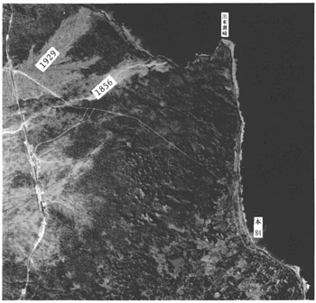
Dekimazaki Peninsula, on the eastern foot of Komagatake, debris containing boulders up to 3m across formed new promontory. The deposits contained welded tuff boulders in addition to Komagatake lava and widely distributed in scattered small hills of hummocky topography. Small hills distributed in Onuma and Konuma area of south foot have the same origin as debris avalanche deposits. The surfaces of those deposits are directly covered by Ko-d ash fall of 1640 which is exactly the way it was described in historical documents. The debris avalanche is named as Kurumizaka Debris Avalanche deposits with total volume of 0.25 km3.The summit of Komagatake was destroyed with this collapse. Probably the collapse was due to phreatic eruption, a forerunner of new active period, to open new conduit after a long dormant period.
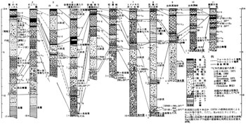
Ash fall deposits of 1640 is named by Yamada ( 1958 ) as Ko-d. The thickness is up to 1 to 2m on the foot reaching Otobe, Atsusawabe, Kamiiso, Usujiri, Kunnui, and Utajima, where it is about 10 cm. This is conformable to descriptions in historical documents which mentioned that ash fall reached Matsumae and Tsugaru regions. The total volume of Ko-d was estimated to be 3.5 km3. Ko-d was subdivided into two ( d1 and d2 ) by Sasaki et al. ( 1970 ). However, Katsui et al. ( 1986 ) revised the subdivision to Ko-d1 to d11 fall units using existence or not of intercalating thin ash bed and discontinuous grain-size distribution as criteria as shown in ![]() Fig. 3.
Fig. 3.
Ko-d1 is volcanic ash and probably indicates the beginning of phreatic eruption. Ko-d2 to d4 are derived from large-scale ash falls and probably belong to products of culminating stage of eruptions from July 31st to August 2nd. Ko-d5 to d10 are pumice falls deposited during this period or extended period till August 3rd. The uppermost Ko-d11 is ash fall probably belonging to declining period of eruption.
No description is found in the old documents suggesting pyroclastic flow for 1640 eruption, but interbedded pyroclastic flow ( pumice flow ) is confirmed within the Ko-d3 fall unit. The pyroclastic flow shows similar nature to that of 1929' s described later and the thickness is about 4 m. Below the pyroclastic flow deposit, pyroclastic surge deposit with cross lamination develops at places.
Eruption of 1694 ( 7th year of Genroku )
In the eastern foot of Komagatake Volcano Ko-d pumice fall is overlain by Ko-c2 pumice fall/pyroclastic flow with intervening thin humus ( ![]() Fig.1 ). In the past Ko-c2 has been provisionally identified as ejecta of 1765 ( 2nd year of Meiwa ). However, Katsui and Ishikawa ( 1981 ) found the following description in ' Tsugaru Domain Country Diary' .
Fig.1 ). In the past Ko-c2 has been provisionally identified as ejecta of 1765 ( 2nd year of Meiwa ). However, Katsui and Ishikawa ( 1981 ) found the following description in ' Tsugaru Domain Country Diary' .
July 11th, 7th year of Genroku
'Earlier this year there was a volcanic eruption in Matsumae. Herewith Aomori Magistrate Office wishes to submit a memorandum of this event which to follow.
1. There's a place called Matsumaeyama Uchiura-take which is about 5 days traveling distance from Matsumae. Several years ago in the year of Kan-ei 18th, 13th day of June there was an eruption accompanied with large tsunami which hit Matsumae and its south resulting in many deaths. At that time the tide was said to go out about 20 ken ( Note: ken is an old unit of length ) at Aomori Hamashio.
1. At Uchiura-take mentioned above, remaining eruptive activity caused earth tremors and thunders from the morning of 4th to 6th.' ( rest of the document abridged )
This diary mentions volcanic eruption with large tsunami in 18th year of Kan-ei ( Note that the year 18th should be a misquotation of 17th ) and further from 4th July to 6th of the 7th year of Genroku eruption occurred with earthquake and thunder. The described eruption is correlated to the event of Ko-c2 pumice fall.
The eruption occurred 54 years after the eruption of 1640. Poor development of humus at the top of Ko-d pumice fall deposit is quite reasonable. Because of the prevailing westerly winds, Ko-c2 pumice fall is found distributed in the east and the thickness is 180 cm at the eastern foot accompanied with pyroclastic flow ( pumice flow ). Volumes of ejecta are; pumice fall 0.26 km3 and pyroclastic flow 0.1 km3. However, most areas where pumice had fallen are located in the sea, and the volume of pumice fall may be larger than this.
Ko-c2 bed consists of at least 5 fall units. Around the middle of the bed, pumice tends to show largest size with interbedded pyroclastic flow. The thickness of flow is largest on topographic depressions. Oxidized flow shows pale reddish brown colors.
After the eruption of 1694 ( 7th year of Genroku ) a simple mention of eruption being occurred in 1765 ( 2nd year of Meiwa ) and 1784 ( 4th year of Tenmei ) was found in the old document, but ejected materials from these activities are not found.
Eruption of 1856 ( 3rd year of Ansei )
Many documents describing eruption of 1856 are found. According to these descriptions, in the early morning of September 25th, many earthquakes were felt at the foot of the mountain followed by furious eruptive activities starting from about 9 o'clock. In the eastern foot, about 60 cm thick pumice deposited and about 2 cm thick ash fall was recorded at the mouth of Tokachigawa River 250 km away in the east. Two people were dead from pumice fall and many injuries resulted. Seventeen houses were burnt down. Tomenoyu, on the southeast foot, pumice fall was followed by pyroclastic flow and many ( 19-27 ) people were killed. High temperature pyroclastic flow temporarily dammed Oritogawa River discharging Onuma Lake and created a new lake overflowing with hot water. The eruption almost ceased by the evening, but small eruptions had continued occasionally for nearly a month.
Ko-c1 is a product of 1856 pumice fall. Its distribution recorded in the old documents is fairly accurate. Ko-c1 in the eastern foot is subdivided into 3-5 fall units, each unit consisting of a regular sequence from pumice fall, pyroclastic flow, and pumice fall in the ascending order. Total volume of Ko-c1 pumice fall is estimated to be about 0.11 km3, but most of it was lost to the sea in the east. Major part of pyroclastic flow is similar to that of 1929 in nature and distributed from flanks to the foot areas and shows reddish brown color due to high temperature oxidation. Near Tomenoyu in the southeast foot, the flow went down along Oritogawa River and formed low-lying pumice flow plateau of several m relative height from the bottom of the river. In the eastern flank, pyroclastic surge accompanying pumice flow left hummocky topography. Total volume of pyroclastic flow is estimated to be about 0.1 km3.
Ansei crater 200m across was formed on the summit in this eruption. Within the crater was formed a small lava dome. In the eruption in 1856, catastrophic stage was finished within short period ( 8-9 hours ). The volume of ejected materials was estimated to be 0.2 km3 at least.
Eruptions between 1856 to 1929
Small scale phreatic explosion on April 4th in 1888 ( 21st year of Meiji )
Small scale phreatic explosions on the south side of Ansei crater on August 19th, 21st -23rd , 25th, 31st and September 1st, 1905 ( 38th year of Meiji ) accompanied with little ash fall centered in Mori, NE foot area.
Fourteen years after small eruption of 1909, another small eruption occurred in 1919 ( 8th year of Taisho ) followed by small scale phreatic eruptions with ash fall in 1922, 1923, and 1929.
Eruption of 1929 ( 4th year of Showa )
On 17th of June, 73 years after the large eruption of Ansei, occurred a large eruption of pumice fall and pumice flow (![]() Fig.4 ). The eruption lasted only a day. Katsui ( 1985 ) compiled detailed story of this eruption based mainly on records by Kozu et al. ( 1932 ) and Tsuya et al. ( 1930 ). Summary of this event is as follows ( ( 1 ) to ( 5 ) each corresponds to pumice fall unit with the same number described later. )
Fig.4 ). The eruption lasted only a day. Katsui ( 1985 ) compiled detailed story of this eruption based mainly on records by Kozu et al. ( 1932 ) and Tsuya et al. ( 1930 ). Summary of this event is as follows ( ( 1 ) to ( 5 ) each corresponds to pumice fall unit with the same number described later. )
Preceding the eruption, on June 15th, a sound was heard and on June 16th tremors ( twice ) were felt.
( 1 ) Small eruption commenced at about 0:30 on 17th.
( 2 ) At about 9:35 the activity changed to catastrophic pumice eruption ( Plinian eruption ). The eruption column reached 13.9 km high at 11:00, and brought pumice fall in SE direction centered in Shikabe. The propagating speed of the ash fall front was about 60 km/hour.
( 3 )At about 12:30 the eruption increased its intensity and small scale pyroclastic flow commenced. At 14:00 the height of eruption column was 13.1 km.
( 4 ) From about 14:30, the amount of pumice falling on crater floor increased and pyroclastic flow came down incessantly on the mountain flanks.
( 5 ) At about 20:00 pumice fall increased intensity but suddenly weakened at 24:00, and the eruption came to the end at 3:00 on 18th.
On 19th due to rainfall secondary mudflow came down to Numajiri.
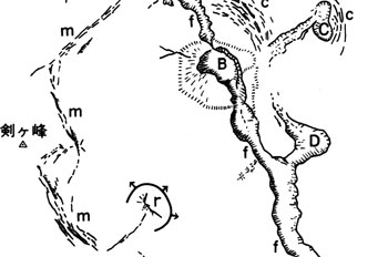
Depth of deposited pumice at Orito, southeast foot, reached 154 cm ( now it is 100-120 cm ) and at Shikabe township 106 cm ( now 70 cm ), and the total volume was estimated to be about 0.38 km3. The pyroclastic flow came down in all four directions covering a total area of 22.5 km2 and total volume is estimated to be 0.14 km3. Death toll was two while four injured, totally destroyed or burnt houses 365, half destroyed or burnt 1500, and caused big damage to livestocks, cultivated land, forest, and fishing ground. The summit changed its shape with Ansei crater completely buried. Showa great crater (diameter 230 m and depth 50 m) was formed slightly to the SE side of Ansei crater. Hisago-shaped and Cocoon-shaped craters along with many fissures were also newly formed (![]() Fig. 5 ).
Fig. 5 ).
Ejecta in crater floor: Pumice ejected in 1929 was 100 m thick in crater floor. Grading of ejecta is poor but other characteristic features of pumice fall are clear in general. At the edge of crater floor part of ejecta shows pyroclastic surge-like features. A 1.6 km fissure in NW-SE direction was opened in the crater floor during the eruption of 1942 and the cross section of the deposits is clearly visible at the fissure. Middle and lower parts of the deposit are welded while upper part is non-welded across gaseous alteration zone ( Katsui et al., 1975 ). It seems that a temporally pumice cone was formed at the time of eruption due to rapid accumulation of a large amount of pumice. However, after 10 days since eruption (June 27th) when Nemoto reached the summit for inspection, such pumice cone was nowhere to be seen although the field of view was largely blocked out by steam and gas, and he just mentioned opening of many fissures ( Nemoto, 1930 ). The pumice cone was decimated by rapid welding of pumice and didn't last long after eruption and only a shallow crater floor remained. Around crater floor were seen many fissures and faults between somma wall and pumice-filled floor due to volume shrinkage of pumice by welding. Although Ansei crater was buried deep in new ejecta, concentric cracks with their center at the old position of the crater were developed in the NE side ( ![]() Fig. 5 ). The cracks lowered the floor step-like toward the old crater suggesting the thickness of pumice was largest at crater site and degree of shrinkage by welding being largest at the crater ( Katsui and Komuro, 1984 ). Similar concentric cracks were also visible on the east side of Cocoon-like crater.
Fig. 5 ). The cracks lowered the floor step-like toward the old crater suggesting the thickness of pumice was largest at crater site and degree of shrinkage by welding being largest at the crater ( Katsui and Komuro, 1984 ). Similar concentric cracks were also visible on the east side of Cocoon-like crater.
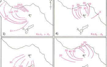
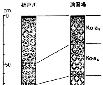
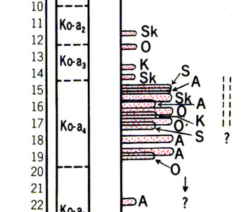
Pumice fall: 1929 pumice fall deposit was named Ko-a bed ( Yamada, 1958 ). Its axis of distribution was in SE direction. Five units, Ko-a1 to a5, were discriminated there in ascending order ( Katsui et al. ( 1986 ). Units were separated by thin volcanic ash beds ( ![]() Fig. 6 ). Regional correlation of these with eruption records revealed that the above described five stages explained as ( 1 ) to ( 5 ) of eruption corresponded to those units (
Fig. 6 ). Regional correlation of these with eruption records revealed that the above described five stages explained as ( 1 ) to ( 5 ) of eruption corresponded to those units ( ![]() Fig. 7 ).
Fig. 7 ).
Outcrops on the summit and flanks of Ko-a1 to a3 are grayish white colored while pumice blocks in Ko-a4 are brownish colored on the surface because of sticking fine-grained ash. Ko-a5 bed is slightly brown colored. On the outcrops in eastern flank-foot, all or nearly all of Ko-a4 fall unit consist of pyroclastic flows. This means that during Ko-a4 fall most flows ran down the slope. Recorded times of flow occurrences match with the observation (![]() Fig. 7). Stuck fine-grained ash on the surface of pumice boulders in Ko-a4 suggests that the space was filled with ash cloud during fall of pumice blocks.
Fig. 7). Stuck fine-grained ash on the surface of pumice boulders in Ko-a4 suggests that the space was filled with ash cloud during fall of pumice blocks.
Pyroclastic flow: Pyroclastic flow ( pumice flow ) deposit consists of poorly sorted pumice, ash, and rock fragments and contains many pumice blocks. In general it spreads like a fan at mouth of a valley accompanied with natural levee and tongue-like lobe topography ( Moriya, 1984 ). Surface of flow unit is covered by large pumice blocks and ash is predominant inside. At Akaigawa River, on the SW foot, up to five flow units are discriminated in an outcrop suggesting many flows ( six according to Nemoto, 1930 ) came down the valley just like described in old documents. Although no clear records are known, pyroclastic surge deposits are distributed on ridge-slope of the flanks in addition to flows forming wave-like topography (Moriya, 1984. Refer to geologic map ). Near Akaigawa River entrance of mountain track on SW flank at about 500 m a.s.l., the deposit shows well developed lamination with better sorting than pumice flow, and stratigraphically underlies ( partly interfingers ) pyroclastic flow which came down the valley. Suzuki et al. ( 1986 ) classified pyroclastic flow deposits into two types: valley type ( pumice flow deposit ) and ridge type ( pyroclastic surge deposit ): Ridge type is high speed less dense pyroclastic flow while valley type not so fast and denser.
Eruption of 1942 ( 17th year of Showa )
On November 16th in 1942, an explosion occurred and a large fissure extending more than 1.6 km was formed in the crater floor at the summit ( Ishikawa and Hashimoto, 1943 ).
The eruption started with sound at about 8 a.m. on November 16th. Smoke rose about 8:10 and reached high at 8:18-20 accompanied with rather strong explosion and earthquake. At about 8:20-23 atmospheric vibration was felt at Onuma, Ikusagawa, and Tomenoyu in the south-southeast foot areas. Thunder and lightning were also witnessed. At the entrance of Jigokuwan mountain track of the northern shore of Onuma, rising of two columns of flame and ejection of large rock blocks from the crater were sighted. Ejection of rock blocks was also sighted from Sahara, northern foot. The blocks seemed to have been lifted more than 100 m into the air. At 8:40 the black smoke gradually changed to white smoke.
The smoke went straight up after the eruption reached 8,000 m and trailed toward Shikabe in the ESE. After 5 minutes, volcanic lapilli started to fall in Honbetsu and Tomenoyu finally reaching Oiwa and Offshore Tokoro. In those areas fall of lapilli was followed by coarse ash and ash in succession. Ash fall stopped within 10-15 minutes in remote places but continued for about 30 minutes in Tomenoyu, till after noon time in Daiichi-Hatsudensho, and till evening in Shikabe. In Shikabe the thickness reached 2 cm. With rise of straight smoke column, the smoke came down the slope in three directions; Jigokuwan in the south, Tomenoyu in southeast, and Shikabe in ESE. The speed was large and it was likely to be pyroclastic surges. Fortunately the surges did not reach houses at the foot.
During this eruption, a fissure of 1.6 km long was created from bottom west end of Sahara-Dake to Sumida-Mori. This fissure connected Showa-Yonen great crater and Hisago-shaped crater and opened parallel to NNS-SSE elongation direction of them ( ![]() Fig. 5 ).
Fig. 5 ).
Solid ejecta included volcanic blocks, pumice, volcanic bomb, lapilli, and ash, all of which were similar to those of 1929. It was not clear if they were derived from new magma or belonged to recycled old ejecta.