Hachijojima Volcano
1: Introduction - 2: Overview of Hachijojima Volcano
3: History of subaerial portion of Hachijojima Volcano
4: Submarine volcanic activities around Hachijojima
5: Historical eruptions - 6: Present activities
7: Petrological characteristics - 8: Characteristics of eruptive activities
Reference
![]() PREV
PREV ![]() NEXT
NEXT
1: Introduction - 2: Overview of Hachijojima Volcano
1: Introduction
The Hachijojima Volcano is a complex volcano on the Izu-Ogasawara Volcanic Arc, constituting Hachijojima of the Izu Island Chain. The part of Hachijojima Volcano above the sea level consists of the Nishiyama Volcano (Hachijo-Fuji) on the northwest part of Hachijojima, Higashiyama Volcano (Mihara-yama) on the southeast part, and Kojima (Hachijo-Kojima) to the west of Hachijojima. The Hachijojima volcano has appeared to have no eruption over 400 years after an eruption in the year 1605 (Year 10 of the Keicho Era) during the early Edo Period. However, fresh volcanic landforms of the Nishiyama Volcano with scarce erosions indicate that these volcanoes are still active. Moreover, the earthquake swarm of August 2002, caused by magma intrusion, indicates that the Hachijojima Volcano is still active.
The base and lower edifice of the Hachijojima Volcano are below sea level. Therefore, when considering the growth history and eruption system of the entire volcano, information pertaining to the entire volcano, which includes the submarine edifices and the bedrock, is essential. This geological map describes the geology of the Hachijojima Volcano based on new field survey results as well as previously-published data.
Distribution of submaribe volcanic edifices in addition to the on-land section is also reported, along with information on the adjacent Kenkenyama Volcano/Kurose-Nishi Hole Volcano, with the objective of obtaining a clear understanding of the entire volcano.
2: Overview of Hachijojima Volcano
2.1 Landforms
Regional submarine landforms
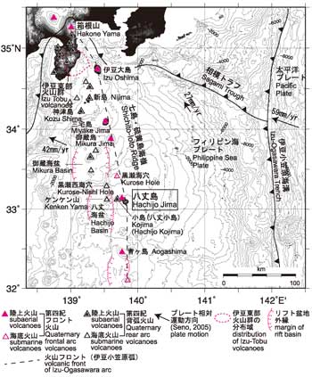
![]() Figure 1 depicts the regional structures including the seafloor around the Hachijojima Volcano, which is located above the Shichito-Ioto Ridge, the volcanic front of the Izu-Ogasawara Arc, stretching from the north to the south. Quaternary volcanoes are aligned above the Shichito-Ioto Ridge. The Mikurajima Volcano is located approximately 80 km to the north of Hachijojima, while the Aogashima Volcano is located approximately 70 km to the south; both are active volcanoes. In addition, a submarine caldera, Kurose Hole, is located approximately 30 km to the north of Hachijojima.
Figure 1 depicts the regional structures including the seafloor around the Hachijojima Volcano, which is located above the Shichito-Ioto Ridge, the volcanic front of the Izu-Ogasawara Arc, stretching from the north to the south. Quaternary volcanoes are aligned above the Shichito-Ioto Ridge. The Mikurajima Volcano is located approximately 80 km to the north of Hachijojima, while the Aogashima Volcano is located approximately 70 km to the south; both are active volcanoes. In addition, a submarine caldera, Kurose Hole, is located approximately 30 km to the north of Hachijojima.
Near Hachijojima, the Izu-Ogasawara Trench axis can be found approximately 200 km east of the Shichito-Ioto Ridge, and the slope between Hachijojima and the Trench has relatively little undulation. To the west of Hachijojima, a basin with a depth of approximately 1500 m from sea level has developed along the west side of the Shichito-Ioto Ridge from the west of Hachijojima to the south of Aogashima over 100 km from the north to south. This is the Hachijo Basin (Honza and Tamaki, 1985), which is a back-arc basin (rift basin) and has a graben-like shape truncated on the east and west by faults. To the west of Kojima, there is a cliff with a relative height of approximately 600 m, which is the eastern edge of the Hachijo Basin, stretching in a north-south direction. The edge of the Hachijo Basin consists of several cliffs with similar strike, which were most likely formed by normal-fault activities based on a seismic reflection survey (Ishizuka et al., 2008). A submarine canyon stretches from the west of the volcanic chain to the north of Hachijojima toward the Hachijo Basin, truncating a part of these cliffs.
Hachijojima is at the northern part of a circular rise with a diameter of 25 km, located on the Shichito-Ioto Ridge. Small satellite cones are located on the surrounding seafloor. In particular, from the north of Hachijojima to the northeast side, there are satellite cones radiating from the summit of the Nishiyama Volcano. These volcanic edifices can be found as far as approximately 7 km away from the shore. An 18-km-long echelon volcanic chain stretches from the Nishiyama Volcano in the NNW direction (Ishizuka et al., 2008). A similar volcanic chain can be traced for approximately 10 km on the seafloor toward the NNW of Kojima. Satellite cones that constitute the volcanic chain are all lower than 200 m in relative height with respect to the seabed, with a base diameter of less than 2 km.
In the Hachijo Basin, a chart shows a seamount named Kenkenyama, located approximately 15 km west of Kojima. The relative height with respect to the surrounding seafloor can exceed 1000 m. A recent survey reported that Kenkenyama is an active volcano consisting of multiple calderas, craters, and lava domes (Ishizuka et al., 2008).
Approximately 20 km north of Kenkenyama, a submarine caldera called Kurose-Nishi Hole occurs in an area where a ridge stretching in the ENE-WSW direction from the Shichito-Ioto Ridge intersects with the Hachijo Basin. Kurose-Nishi Hole is oval-shaped, with a long diameter of 7–8 km, and relative height of up to 1000 m. A structural cross section indicates that Kurose-Nishi Hole is a caldera volcano (Murakami and Ishihara, 1985). Pumice, which most likely erupted from this caldera, litters the seabed north of Hachijojima, including the volcanic chain.
Subaerial landforms
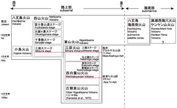
The subaerial portion of Hachijojima is a volcanic island where two volcanic edifices, the Higashiyama Volcano and Nishiyama Volcano, are joined in the shape of a gourd stretching northwest and southeast. Hachijojima has a length of approximately 14 km with an area of 69 km2. Its highest point is the Nishiyama Volcano (Hachijo-Fuji) at a height of 854 m. The Higashiyama Volcano consists of multiple complex volcanic edifices that are dissected. ![]() Figure 2 illustrates the stratigraphic relationship of the subaerial portion of the Hachijojima Volcano.
Figure 2 illustrates the stratigraphic relationship of the subaerial portion of the Hachijojima Volcano.
The oldest and most weathered volcanic edifices are found along the outer rim of the Higashiyama Volcano (Kaminato (Sokodo) Port–Noboryo Toge–northern Sueyoshi, from Borawazawa to Koiwadogahana at the southern point of Hachijojima, and Yokomagaura). As the shoreline is heavily eroded, the majority is surrounded by high sea cliffs. Overlying these volcanoes is the stratovolcano that constitutes the center of the Higashiyama Volcano. This volcanic edifice can be divided into an edifice older than the Nishihakuunzan Caldera (Tsukui et al., 1991) at the summit of the Higashiyama Volcano (Nishihakuunzan Volcano) and the Mihara Volcano that developed inside the caldera.
Nishiyama Volcano has a relatively simple cone shape with a diameter of approximately 6 km, and its shape led to the name Hachijo-Fuji. However, the slope changes around the elevation of 500–600 m, and Oshima (1989) argued that this is the trace of a caldera that was buried by a volcanic edifice that developed inside. At the summit, there is a circular crater with a diameter of approximately 500 m. Hardly any erosional valley exists on the surface of the Nishiyama Volcano, and fresh lava flow morphology can been found. In some areas, pahoehoe and aa basalts can be recognized based on surface structures. Coastal cliffs surrounding the Nishiyama Volcano are generallylower than 100 m high, generally lower than those surrounding the Higashiyama Volcano. A wide and gentle slope consisting of lava flows exists, where the Nishiyama Volcano joins the Higashiyama Volcano, in which the major urban areas of Hachijo-machi and Hachijojima Airport are located. Although the surface of this gentle slope is artificially altered, the flat surface of the lava flow and the terminal and lateral cliffs of lava flows are clearly visible. Several cinder cones are also formed because of the secondary cone activities on this gentle surface. The most notable is the crater chain that passes through Hachijojima Airport and stretches into Hachijo Botanical Park.
Kojima is an island with a length of 3 km, width of 1.5 km, and area of approximately 3 km2, located approximately 2 km west of Hachijojima and having a cone shape that stretches northwest to southeast. The highest point is Otairasan with a peak of 617 m. The relative height with respect to the surrounding seafloor is approximately 1100 m. The northeast and southwest sides are high sea cliffs almost reaching near the summit. The sea cliffs on the southeast and northwest sides are relatively low. The flanks on the southeast and northwest sides preserve relatively clear lava flow morphology.
![]() PREV
PREV ![]() NEXT
NEXT