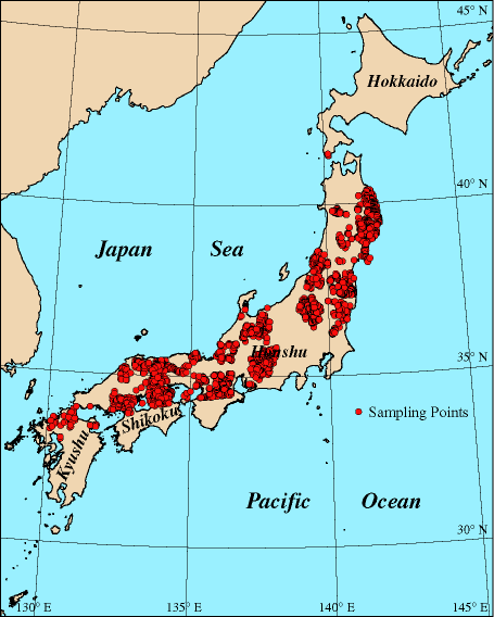
 PB-Rock 21 is a Petrophysical Data Base of Basement Rocks in Japan for the 21st Century constructed by the Geological Survey of Japan (GSJ), AIST. The GSJ has been measuring petrophysical properties of basement rocks
such as granitic and metamorphic rocks in Japan to better understand the
geological and geophysical structures of the Japanese Islands for more
than thirty years. We had disclosed the data of the northern Tohoku region
(yellow area in the index map), the Chubu, Hokuriku and Hida regions (pink area), the Kinki East region (green area), the Abukuma region (orange area) and the Kinki West, Chugoku East and Hokkaido South regions (blue areas) as one of the RIO-DB (Research Information Data Base) to share the knowledge
since 2002. We added the data from the Chugoku Central region and the
Kanto North region (purple area) to the data base. Furthermore, we have added the data from the Chugoku Central region and
the Northern Kyushu region (grey area) to the data base. The data base itself consists of petrophysical data
such as magnetic susceptibility, intensity of natural remanent magnetization
(NRM), Qn ratio, Curie temperature, dry density, wet density, porosity,
and ultrasonic velocity with the information of lithology, sampling locations
and registration numbers of rock samples at the Geological Museum of the
GSJ. The total number of sample locations amounts to be 2,947 up to now.
PB-Rock 21 is a Petrophysical Data Base of Basement Rocks in Japan for the 21st Century constructed by the Geological Survey of Japan (GSJ), AIST. The GSJ has been measuring petrophysical properties of basement rocks
such as granitic and metamorphic rocks in Japan to better understand the
geological and geophysical structures of the Japanese Islands for more
than thirty years. We had disclosed the data of the northern Tohoku region
(yellow area in the index map), the Chubu, Hokuriku and Hida regions (pink area), the Kinki East region (green area), the Abukuma region (orange area) and the Kinki West, Chugoku East and Hokkaido South regions (blue areas) as one of the RIO-DB (Research Information Data Base) to share the knowledge
since 2002. We added the data from the Chugoku Central region and the
Kanto North region (purple area) to the data base. Furthermore, we have added the data from the Chugoku Central region and
the Northern Kyushu region (grey area) to the data base. The data base itself consists of petrophysical data
such as magnetic susceptibility, intensity of natural remanent magnetization
(NRM), Qn ratio, Curie temperature, dry density, wet density, porosity,
and ultrasonic velocity with the information of lithology, sampling locations
and registration numbers of rock samples at the Geological Museum of the
GSJ. The total number of sample locations amounts to be 2,947 up to now.To | What's New | Japanese Top Page | Okuma's Home | IGG |
![]()
© AIST, 2002-2011 All Rights Reserved. All materials presented on
PB-Rock 21 are the exclusively property of AIST. Unauthorized reproduction
or use of all or part of these materials is prohibited.