| 形式 | 名称 | URI |
|---|
| TXT | | https://www.gsj.jp/data/coastal-geology/GSJ_SGMCZ_S4_2014_readme.zip |
| PDF | | https://www.gsj.jp/data/coastal-geology/GSJ_SGMCZ_S4_2014_Study_map.pdf |
| PDF | (0) Preface by Y. Okamura: | https://www.gsj.jp/data/coastal-geology/GSJ_SGMCZ_S4_2014_00.pdf |
| PDF | (1) 1:200,000 Marine geological map along the coastal zone around Yufutsu Plain with explanatory notes, by T. Sato: | https://www.gsj.jp/data/coastal-geology/GSJ_SGMCZ_S4_2014_01_a.pdf |
| PDF | (1) 1:200,000 Marine geological map along the coastal zone around Yufutsu Plain with explanatory notes, by T. Sato: | https://www.gsj.jp/data/coastal-geology/GSJ_SGMCZ_S4_2014_01_b.pdf |
| JPEG | (1) 1:200,000 Marine geological map along the coastal zone around Yufutsu Plain with explanatory notes, by T. Sato: | https://www.gsj.jp/data/coastal-geology/GSJ_SGMCZ_S4_2014_01_c.zip |
| JPEG | (1) 1:200,000 Marine geological map along the coastal zone around Yufutsu Plain with explanatory notes, by T. Sato: | https://www.gsj.jp/data/coastal-geology/GSJ_SGMCZ_S4_2014_01_d.zip |
| PDF | (2) Sediments and sedimentation on the shelf off Yufutsu, Hokkaido, Japan, by H. Katayama, Y. Uchida, K. Koshimizu, N. Nishida, K. Ikehara, and R. Nakashima: | https://www.gsj.jp/data/coastal-geology/GSJ_SGMCZ_S4_2014_02.pdf |
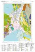
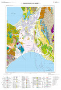
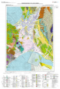
| PDF | (3) 1:200,000 Land geological map in the Ishikari Depression and its surrounding area with explanatory note, by M. Ozaki and T. Komatsubara: | https://www.gsj.jp/data/coastal-geology/GSJ_SGMCZ_S4_2014_03_a.pdf |
| PDF | (3) 1:200,000 Land geological map in the Ishikari Depression and its surrounding area with explanatory note, by M. Ozaki and T. Komatsubara: | https://www.gsj.jp/data/coastal-geology/GSJ_SGMCZ_S4_2014_03_b.pdf |
| PDF | (4) The boring survey of the upper Quaternary in the Yufutsu Plain and Shikotsu Pyroclastic Flow Upland, central Hokkaido Island, northern Japan, by T. Komatsubara, J. Komatsubara, M. Hongo, S. Tanabe, T. Ueki, R. Nakashima, and T. Ishihara: | https://www.gsj.jp/data/coastal-geology/GSJ_SGMCZ_S4_2014_04_a.pdf |
| PDF | (4) The boring survey of the upper Quaternary in the Yufutsu Plain and Shikotsu Pyroclastic Flow Upland, central Hokkaido Island, northern Japan, by T. Komatsubara, J. Komatsubara, M. Hongo, S. Tanabe, T. Ueki, R. Nakashima, and T. Ishihara: | https://www.gsj.jp/data/coastal-geology/GSJ_SGMCZ_S4_2014_04_b.zip |
| PDF | (5) Subsurface geology and active structures beneath the Yufutsu Plain and Shikotsu Pyroclastic Flow Upland, by T. Komatsubara, Y. Kou, and J. Komatsubara: | https://www.gsj.jp/data/coastal-geology/GSJ_SGMCZ_S4_2014_05.pdf |
| PDF | (6) The shallow-level subsurface geologic structure based on analysis of borehole data in the Naganuma lowland and the adjacent area of the central Ishikari Lowland Zone, Hokkaido, by K. Kimura, Y. Kou and Y. Hanashima: | https://www.gsj.jp/data/coastal-geology/GSJ_SGMCZ_S4_2014_06.pdf |
| PDF | (7) Processing of seismic reflection survey data newly conducted around the Yufutsu area, Hokkaido, Japan, by T. Yokokura, K. Yamaguchi, and S. Okada a: | https://www.gsj.jp/data/coastal-geology/GSJ_SGMCZ_S4_2014_07_a.pdf |
| JPEG | (7) Processing of seismic reflection survey data newly conducted around the Yufutsu area, Hokkaido, Japan, by T. Yokokura, K. Yamaguchi, and S. Okada a: | https://www.gsj.jp/data/coastal-geology/GSJ_SGMCZ_S4_2014_07_b.zip |
| PDF | (8) Re-processing of offshore and onshore seismic reflection survey data around Yufutsu area, Hokkaido, Japan, by K. Yamaguchi, T. Yokokura, S. Okada, and S. Abe: | https://www.gsj.jp/data/coastal-geology/GSJ_SGMCZ_S4_2014_08.pdf |
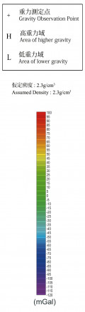
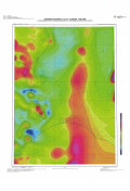
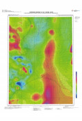
| PDF | (9) 1:200,000 Gravity map of the Ishikari Depression and its surrounding area (Bouguer Anomalies) with explanatory notes, by M. Komazawa, S. Okuma, and M. Joshima: | https://www.gsj.jp/data/coastal-geology/GSJ_SGMCZ_S4_2014_09_a.pdf |
| PDF | (9) 1:200,000 Gravity map of the Ishikari Depression and its surrounding area (Bouguer Anomalies) with explanatory notes, by M. Komazawa, S. Okuma, and M. Joshima: | https://www.gsj.jp/data/coastal-geology/GSJ_SGMCZ_S4_2014_09_b.pdf |
| TXT | (9) 1:200,000 Gravity map of the Ishikari Depression and its surrounding area (Bouguer Anomalies) with explanatory notes, by M. Komazawa, S. Okuma, and M. Joshima: | https://www.gsj.jp/data/coastal-geology/GSJ_SGMCZ_S4_2014_09_c.txt |
| TXT | (9) 1:200,000 Gravity map of the Ishikari Depression and its surrounding area (Bouguer Anomalies) with explanatory notes, by M. Komazawa, S. Okuma, and M. Joshima: | https://www.gsj.jp/data/coastal-geology/GSJ_SGMCZ_S4_2014_09_d.txt |
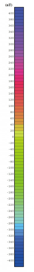
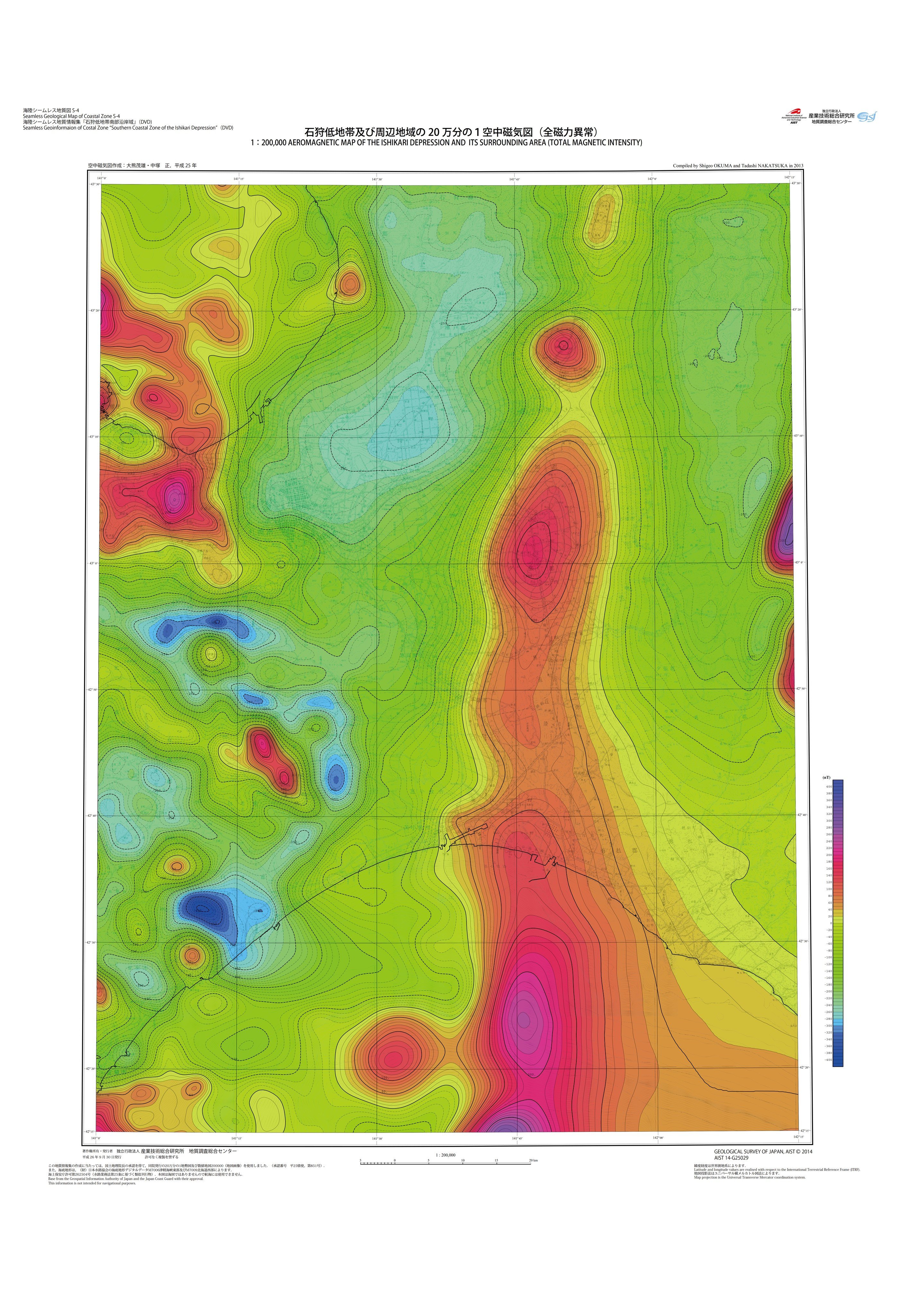
| PDF | (10) 1:200,000 Aeromagnetic map of the Ishikari Depression and its surrounding area (Total Magnetic Intensity) with explanatory notes, by S. Okuma and T. Nakatsuka: | https://www.gsj.jp/data/coastal-geology/GSJ_SGMCZ_S4_2014_10_a.pdf |
| PDF | (10) 1:200,000 Aeromagnetic map of the Ishikari Depression and its surrounding area (Total Magnetic Intensity) with explanatory notes, by S. Okuma and T. Nakatsuka: | https://www.gsj.jp/data/coastal-geology/GSJ_SGMCZ_S4_2014_10_b.pdf |
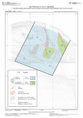
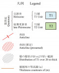
| PDF | (11) Active structures and basal topography of the Alluvium (Post-glacial deposits) in the southern part of the Ishikari Depression and off Yufutsu region, central Hokkaido, by T. Sato and T. Komatsubara: | https://www.gsj.jp/data/coastal-geology/GSJ_SGMCZ_S4_2014_11.pdf |
| PDF | (12)Subsurface geological structure revealed by seismic reflection surveys around the southern part of the eastern boundary fault zone of the Ishikari lowland, Hokkaido, Japan, by T. Yokokura, S. Okada, and K. Yamaguchi: | https://www.gsj.jp/data/coastal-geology/GSJ_SGMCZ_S4_2014_12_a.pdf |
| JPEG | (12)Subsurface geological structure revealed by seismic reflection surveys around the southern part of the eastern boundary fault zone of the Ishikari lowland, Hokkaido, Japan, by T. Yokokura, S. Okada, and K. Yamaguchi: | https://www.gsj.jp/data/coastal-geology/GSJ_SGMCZ_S4_2014_12_b.zip |
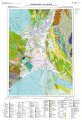
| PDF | (13) 1:200,000 Marine and land geological map of the Ishikari Depression and its surrounding area, by T. Sato, M. Ozaki, and T. Komatsubara: | https://www.gsj.jp/data/coastal-geology/GSJ_SGMCZ_S4_2014_13.pdf |
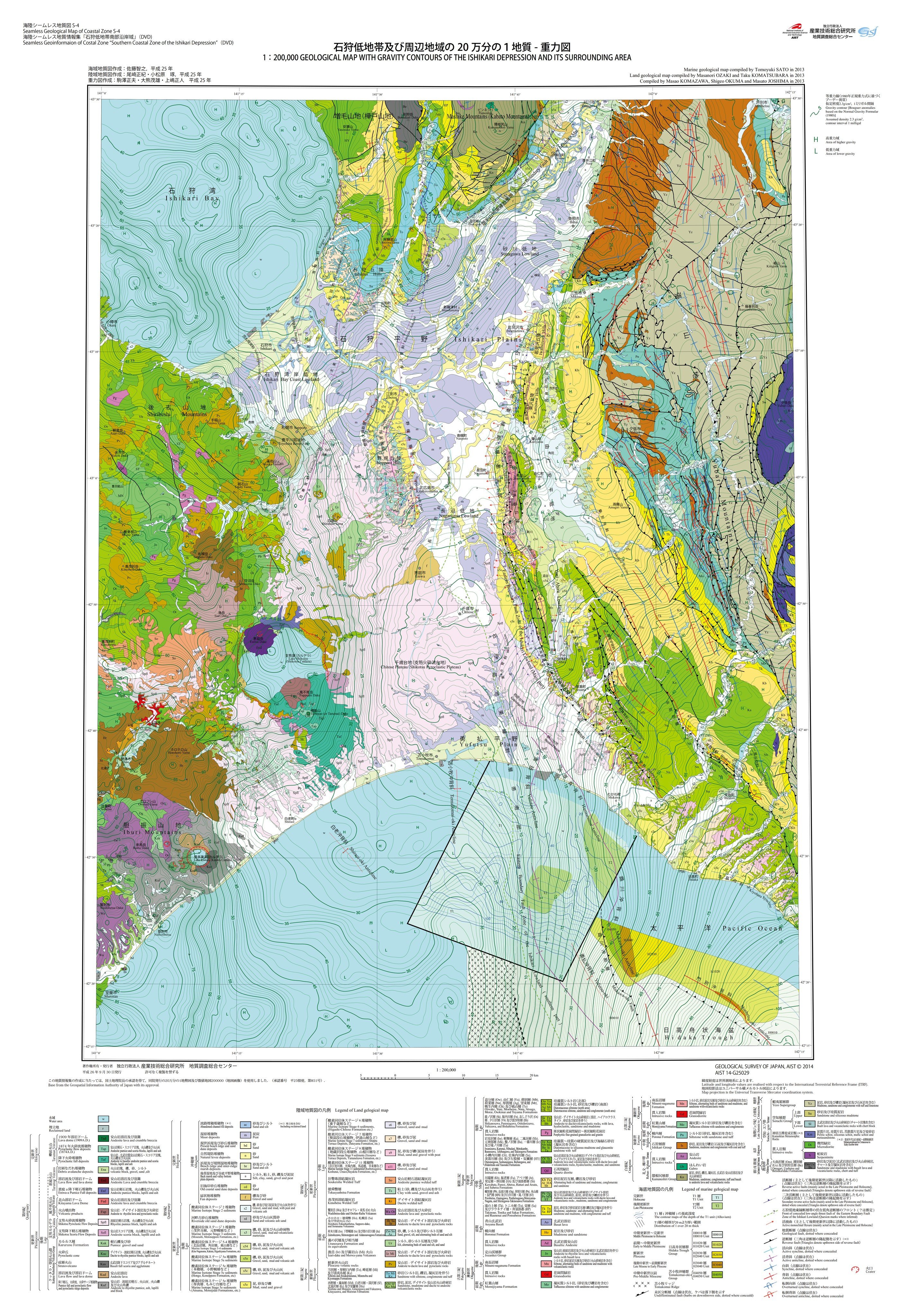
| PDF | (14) 1:200,000 Geological map with gravity contours of the Ishikari Depression and its surrounding area, by M. Komazawa, S. Okuma, M. Joshima, T. Sato, M. Ozaki, and T. Komatsubara: | https://www.gsj.jp/data/coastal-geology/GSJ_SGMCZ_S4_2014_14.pdf |
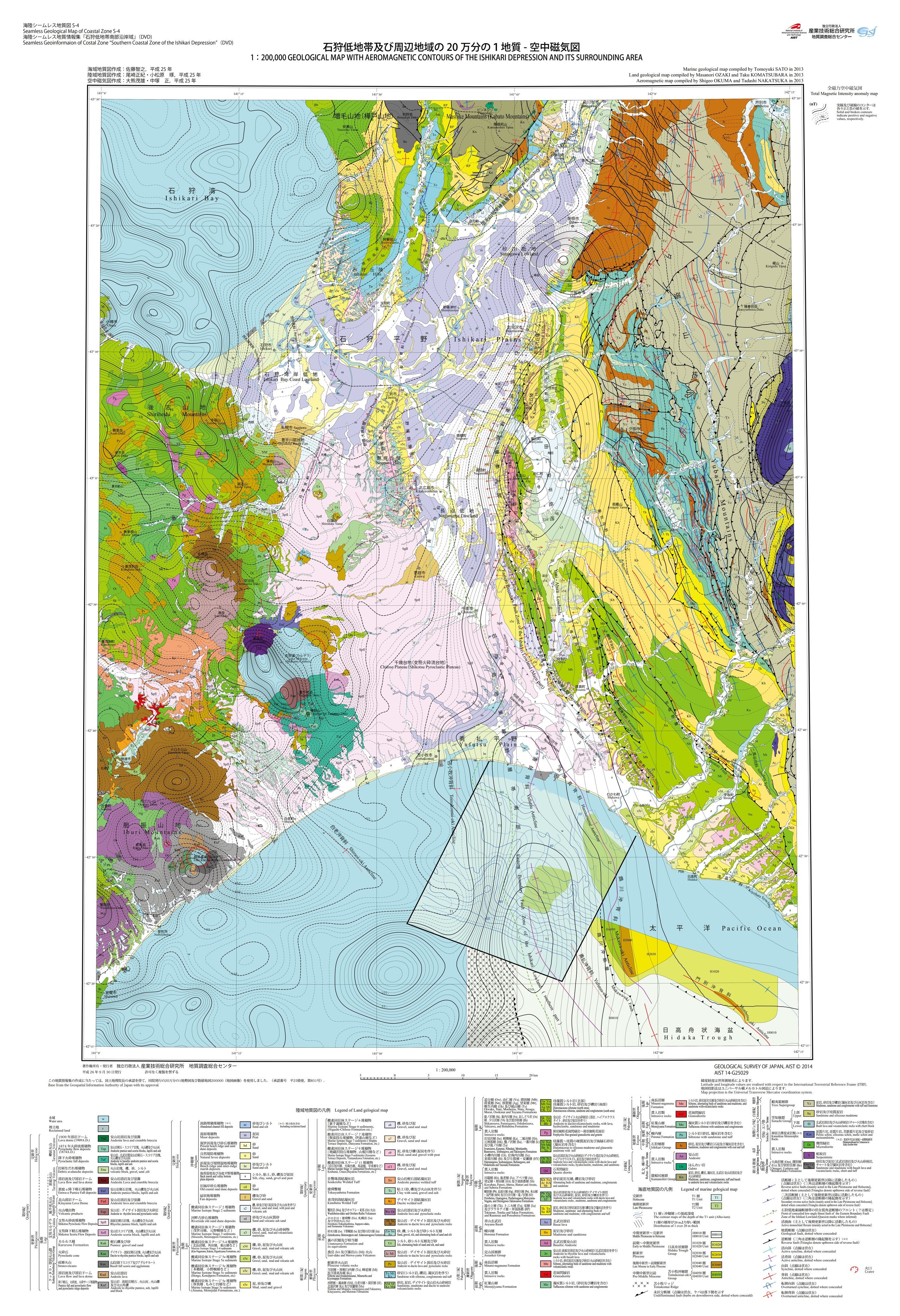
| PDF | (15) 1:200,000 Geological map with aeromagnetic contours of the Ishikari Depression and its surrounding area, by S. Okuma, T. Nakatsuka, T. Sato, M. Ozaki, and T. Komatsubara: | https://www.gsj.jp/data/coastal-geology/GSJ_SGMCZ_S4_2014_15.pdf |
| PDF | (16) 1:200,000 Aeromagnetic map with gravity contours of the Ishikari Depression and its surrounding area, by S. Okuma, M. Komazawa, T. Nakatsuka, and M. Joshima: | https://www.gsj.jp/data/coastal-geology/GSJ_SGMCZ_S4_2014_16.pdf |


