Linked Data: Geological Survey of Japan
JSON
RDF
GSJ LD
Linked Data Service of GSJ
GSJ LD
Literature
Volcano
Specimen
Publication
Image
GSJ LD
>>
Publication
>>
map
>>
g050
>> map98
GSJ Publication
item
description
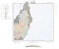
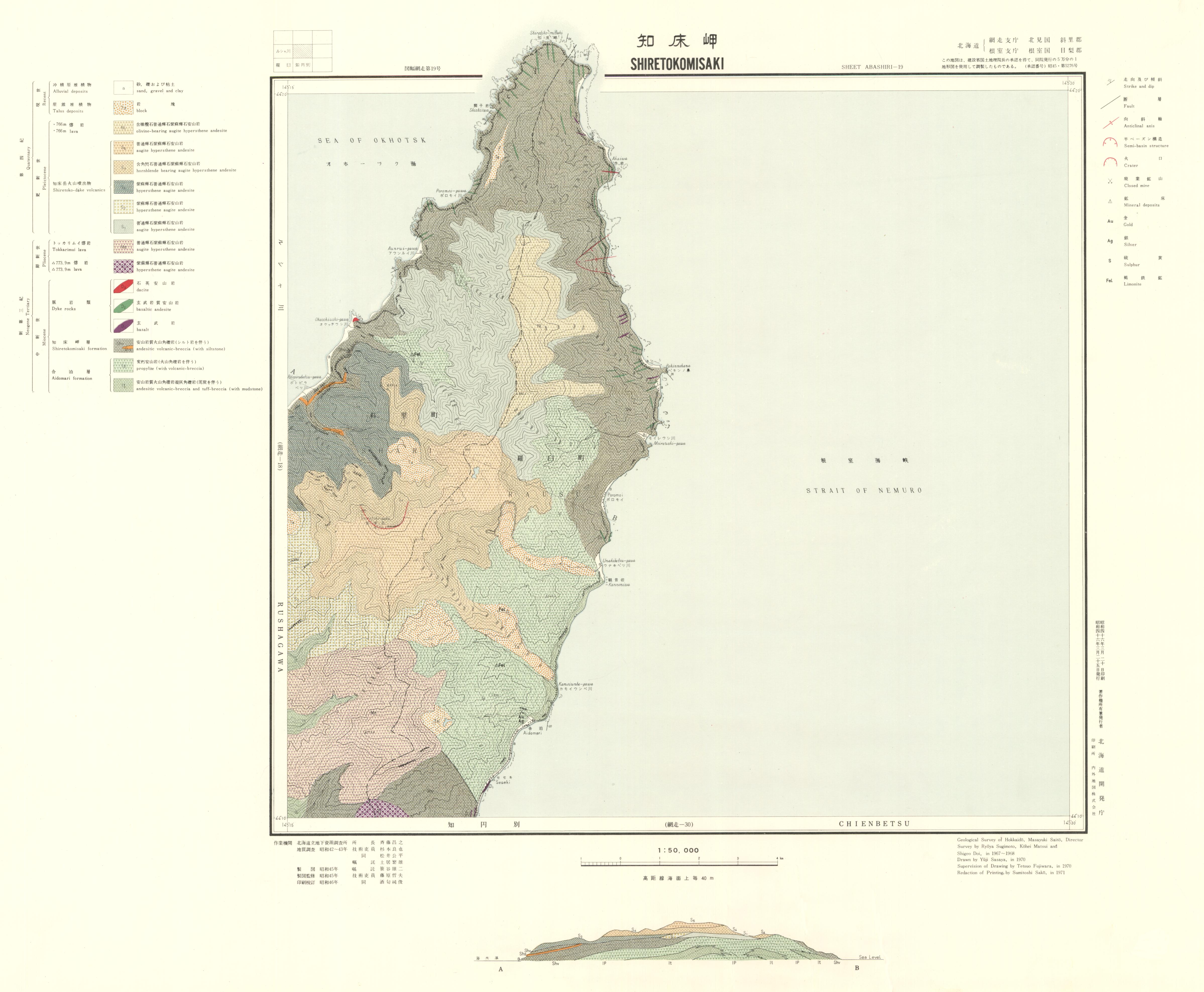
Map name
1:50K GeoMap 'Shiretokomisaki' (1971)
Series
Geological Map, 1:50,000
Author
SUGIMOTO Ryoya, MATSUI Kohei, DOI Shigeo
Tribute
1 Abashiri, 19, 1-21, 1 sheet
Publish year
1971
Publisher
Hokkaido Development Agency
@id
https://gbank.gsj.jp/ld/resource/publication/map/g050/map98
location
Sheet 1
Sheet
Item
Content
TileJSON
https://gbank.gsj.jp/geonavi/maptile/v2/getTileJson/G50_01_019shiretokomisaki.json
Original
Image
Content
https://gbank.gsj.jp/ld/resource/image/map/gsj_map_98_org_98.jpg
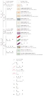
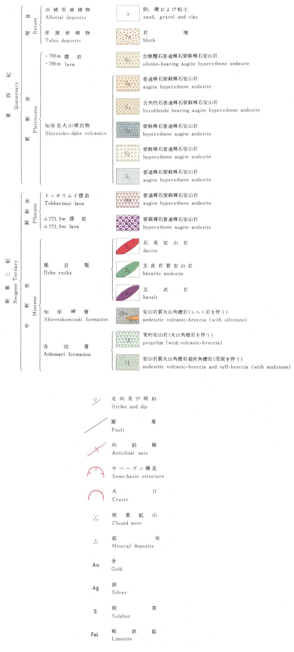
Legend
Image
Content
https://gbank.gsj.jp/ld/resource/image/map/gsj_map_98_legend_140.jpg
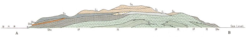
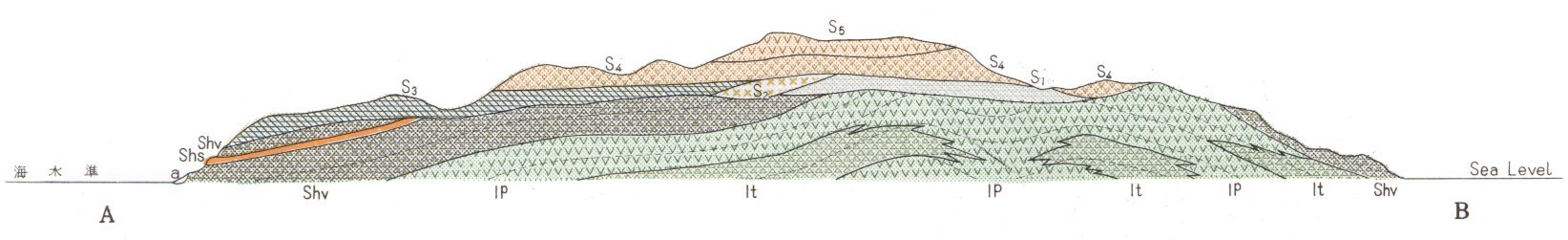
Section
Item
Image
Content
Section: AB
位置(GeoJSON)
https://gbank.gsj.jp/ld/resource/image/map/gsj_map_98_section_29.jpg
sameAs
分類
名称
URI
文献
杉本良也,松井公平,土居繁雄 (1971) 5万分の1地質図幅「知床岬」及び説明書
https://gbank.gsj.jp/ld/resource/geolis/99905317
isPartOf
分類
名称
URI
出版物シリーズ
Geological map
https://gbank.gsj.jp/ld/resource/publication/map/g050
hasPart
分類
名称
URI
鉱床・鉱徴地
要素グループ:鉱床位置情報
https://gbank.gsj.jp/ld/resource/mine/group/gsjmap98
seeAlso
分類
名称
URI
Viewer
GeomapNavi: 1:50K GeoMap 'Shiretokomisaki' (1971)
https://gbank.gsj.jp/geonavi/geonavi.php?layers=98
downloadData
形式
名称
URI
PDF
https://www.gsj.jp/data/50KGM/PDF/GSJ_MAP_G050_01019_1971_D.pdf
JPEG
https://www.gsj.jp/data/50KGM/JPG/GSJ_MAP_G050_01019_1971_200dpi.jpg
GeoTiff/KML
https://www.gsj.jp/data/50KGM/GTF/GSJ_MAP_G050_01019_1971.zip