Aso Volcano
Introduction / Topography of the caldera / Growth history of Aso volcano
Volcanoes within the caldera and their rocks
Nakadake
Rocks of Aso volcano / Hot springs and groundwater
Eruptive activities
Surveillance and observation of activities
References
![]() PREV
PREV ![]() NEXT
NEXT
Introduction / Topography of the caldera / Growth history of Aso volcano
Introduction
Aso is one of the most active volcanoes in Japan. Its Nakadake crater emits column of smoke all the time, and at times violently erupts causing various hazards including human casualties and damage to buildings and agriculture. The Aso volcano is a cluster of central volcanoes situated within a caldera, the size of which is 25 km NS by 18 km EW. Its history extends nearly 300 thousand years of complex activities and growths. The area belongs to the Aso National Park known by its beauty and grandeur and is visited by over 5 million sightseers annually. Within the caldera are six towns and villages and overall population reaches to 50,000. Two railway lines and several highways pass through the caldera. Therefore, prediction of eruption and mitigation of damage are vitally important. This geologic map of the volcano is a compilation of all the research hitherto available and we wish this map is widely utilized for future scientific studies, prediction of eruption, mitigation of damage, sightseeing, and local economic developments.
Topography of the caldera
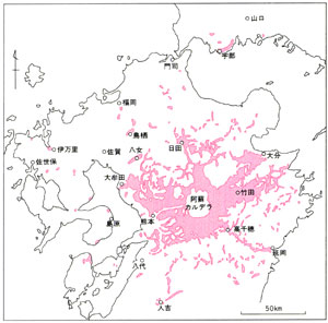
The caldera is a large basin surrounded by steep cliffs. A cluster of central volcanoes dividing the caldera into two is concentrated in southerly position of the NS elongated caldera center. Wide and flat area of caldera bottom in the north is called Aso Valley while southern part is called Nango Valley. Shirakawa River discharging Nango Valley to the west merges with Kurokawa River, which discharge Aso Valley, at the western margin of the caldera, and flows down to Kumamoto Plain in the west through Tateno. The railway and highway connecting Kumamoto and Aso pass this narrow gorge.
Caldera wall in the north of Aso Valley is about 300 m high with top surface being nearly flat. On the other hand, caldera south wall to the south of Nango Valley is about 300 to 700 m high and shows dissected topography of alternating ridges and deep valleys in strong contrast with northern caldera wall.
Outside of the caldera in the east and north spreads very gently sloped( 1-2? )plateau formed by upper surface of a pyroclastic flow. In the south and west of the caldera are flanks of old volcanoes with about 10? slopes abutting with a plateau of Aso pyroclastic flow deposit further outside.
Growth history of Aso volcano
Until the formation of the caldera
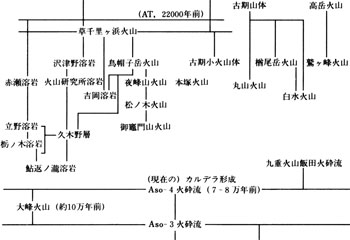
Activity of Aso volcano started about 300 thousand years ago. Before current Aso caldera was formed at about 70 to 80 thousand years before present, four large eruptions preceded it. In ascending order the eruptions and ejecta are named Aso-1, Aso-2, Aso-3, and Aso-4. In each activity large amount of ashes and pumices were ejected first into high air depositing them in the east ( pyroclastic fall deposits ) followed by pyroclastic flows in all directions ( ![]() Fig. 1 ). The eruptions were well beyond the scales known in recent years; for example, Aso-4 not only formed widespread plateau around Aso volcano, but also reached to east, north, and west coasts even to Amakusa Shimojima of west Kyushu and north to Akiyoshidai Plateau of Yamaguchi Prefecture across the sea.
Fig. 1 ). The eruptions were well beyond the scales known in recent years; for example, Aso-4 not only formed widespread plateau around Aso volcano, but also reached to east, north, and west coasts even to Amakusa Shimojima of west Kyushu and north to Akiyoshidai Plateau of Yamaguchi Prefecture across the sea.
Current shape of the caldera was completed immediately after the eruption of Aso-4 about 70 to 80 thousand years before present, but the caldera was not formed only by Aso-4. Initial caldera was formed immediately after Aso-1 and gradually enlarged during successive eruptions. Repeated smaller eruptions of ash, pumice etc. are recorded in between four large eruptions. For example, a lava flow activity between Aso-1 and Aso-2 is known.
Formation of cluster of central volcanoes - post-caldera activities
With little time gap after Aso-4 pyroclastic flow eruption, next volcanic activity commenced within the caldera and formed a cluster of successive central volcanoes. There are 17 independent volcanoes but this is minimum figure because early ones may have been buried by ejecta of later volcanoes. Among the clusters Nakadake is currently active.
In post-caldera activities, wide ranging magmas from basalt to rhyolite were active resulting in variable shapes and structures of volcanoes largely controlled by the rock types. This variation of rock types and topography within a single volcanic group is truly characteristic of the Aso volcano. The sequence of formation of individual volcano is shown in ![]() Table 1.
Table 1.
In contrast to volcanic activities, at least two lake-forming stages are recognized within the caldera. The old lake is represented by Kugino Formation in the west of Nango Valley, and the new one formed flat surface of current Aso Valley by aggrading.
![]() PREV
PREV ![]() NEXT
NEXT