Unzen Volcano
Introduction / Geology and petrography of Asama Volcano and environs / Outline of Unzen volcano
Older Unzen volcano / Younger Unzen volcano
Eruptions of 1663-64 and 1792 / Eruptions since 1990
Surveillance and observation of volcanic activities / Concluding remarks
References
![]() PREV
PREV ![]() NEXT
NEXT
Surveillance and observation of volcanic activities / Concluding remarks
Surveillance and observation of volcanic activities
Shimabara Earthquake & Volcano Observatory, Faculty of Science, Kyushu University has been established in the City of Shimabara, and Unzendake Meteorological Station, Meteorological Agency in Unzen Hot Spring, Town of Obama, to work on surveillance of volcanic activities of Unzen volcano. After the commencement of recent activities, other institutions including Joint University Observation Team, Geological Survey of Japan and Self Defense Force have started cooperative observations. Based on data thus obtained, Coordinating Committee for Prediction of Volcanic Eruptions oversees the volcanic activity. In the following passages, major observation items the Geological Survey of Japan is responsible are described and what other institutions are working on are listed. Distribution of observation stations for electronic distance meter and seismographs are shown in the map.
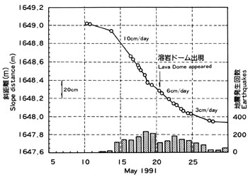
At Geological Survey of Japan various observations have been carried out since current activity has commenced. In February 1991, first mirror for electronic distance meter was placed on the south side of Jigokuato crater followed by more extensive placement of the instrument. On May 13th 1993 a clear inflation of the mountain body ( shortening of distance ) was detected with the maximum change of 10 cm/day. After a week lava appeared ( ![]() Fig. 6 ). At the same time Jigokuato crater and surrounding areas subsided forming graben with accompanying bulge outside of graben. After the lava eruption the bulge of mountain body continued slowly. In March 1993 and November the same year to July 1994, parts of NW and S sides of the mountain inflated suddenly. On the other hand, no anomaly has been detected in Mayuyama where continuous observations have been carried out as well. Based on the energy content calculated from the seismic wave pattern of pyroclastic flow while it is flowing recorded at Unzendake Meteorological Station, the scale ( amount of collapsed volume ) of pyroclastic flow was estimated. With this method the scale of pyroclastic flow is easily estimated as soon as the outbreak of the pyroclastic flow.The results are not swayed by weather conditions. The accumulated amount of erupted pyroclastic flows was estimated to be 0.2 km3 at the point of time on September 14th 1994.
Fig. 6 ). At the same time Jigokuato crater and surrounding areas subsided forming graben with accompanying bulge outside of graben. After the lava eruption the bulge of mountain body continued slowly. In March 1993 and November the same year to July 1994, parts of NW and S sides of the mountain inflated suddenly. On the other hand, no anomaly has been detected in Mayuyama where continuous observations have been carried out as well. Based on the energy content calculated from the seismic wave pattern of pyroclastic flow while it is flowing recorded at Unzendake Meteorological Station, the scale ( amount of collapsed volume ) of pyroclastic flow was estimated. With this method the scale of pyroclastic flow is easily estimated as soon as the outbreak of the pyroclastic flow.The results are not swayed by weather conditions. The accumulated amount of erupted pyroclastic flows was estimated to be 0.2 km3 at the point of time on September 14th 1994.
Summary of observations carried out by other institutions are listed below.
Earthquake and volcanic tremor : Earthquakes and volcanic tremors have been recorded by seismographs installed by Kyushu University and Meteorological Agency.
Visual observation: With the assistance of Self Defense Army of Japan visual observations have been carried out from the air by Shimabara Earthquake and Volcanic Observatory and Joint University Observation Team on the growth of lava domes and flowing processes of pyroclastic flow. The Self Defense Army has been engaged in monitoring of pyroclastic flow and fall of rocks 24 hours a day from fixed point.
Crustal movement (range) : Observations using GPS data on fixed points have been continuously carried out around Fugendake and Shimabara Peninsula. Changes of mountain shapes and distances are monitored by Kyushu University, Kyoto University, Geographical Survey Institute and others.
Crustal movement (height) : Leveling survey has been performed along east and west coasts of Shimabara Peninsula by Geographical Survey Institute and Kyoto University. Tidal observations have been performed for average monthly changes in Shimabara Peninsula and environs by Geographical Survey Institute.
Crustal movement (tilt) : Daily amount of erupted lava is calculated from data on the size of tremor and frequency obtained with tiltmeter installed at Fugendake by Kyushu University and Tokyo University.
Electricity and magnetism : Total magnetism is measured with proton magnetometers ( Kyoto University, Kyushu University, and Japan Meteorological Agency ).
Gravity : Gravity meters were installed around Fugendake and precise measurements are in progress ( Tohoku University etc. )
Concluding remarks
While preparing this geologic map, many published papers have been consulted. During field work Kazuya Ota, Head of the Shimabara Earthquake and Volcanological Observatory of Kyushu University, and his staff members, members of Joint University Observation Team, Unzendake Weather Station of Meteorological Agency, and Japan Self Defense Force helped us. Also late Koji Ono and Shinzaburo Hori of Oyo Chishitsu Co. Ltd. and Toru Danhara of Kyoto Fission Track Co. Ltd. gave us many valuable suggestions. We'd like to express our sincere thanks to the above people.